Sebastian County is a county located in the U.S. state of Arkansas. As of the 2020 census, the population was 127,799, making it the fourth-most populous county in Arkansas. The county has two county seats, Greenwood and Fort Smith.

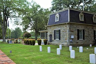
Camp Nelson Confederate Cemetery is a historic cemetery located near Cabot in northern Lonoke County, Arkansas and is near the site of a Confederate military camp Camp Hope, where 1,500 Confederate soldiers died during an epidemic during the fall of 1862. Camp Nelson Cemetery is located on Rye Drive, just off Cherry Road, just off Mt. Carmel Road in north Lonoke County about 2 miles east of Cabot.

Arkansas Highway 22 is an east–west state highway in the Arkansas River Valley. The route runs 75.60 miles (121.67 km) from US 64 in Fort Smith east to Highway 7 in Dardanelle. Following the historic stagecoach line of the cross-country Butterfield Trail, the route is one of the original 1926 state highways. It is designated by the AHTD as the True Grit Trail.
Elmwood Cemetery may refer to several places in the United States:
Fort Harrison National Cemetery is a United States National Cemetery located seven miles (11 km) south of the city of Richmond, in Henrico County, Virginia. Administered by the United States Department of Veterans Affairs, It encompasses 1.5 acres (0.61 ha), and as of the end of 2005, had 1,570 interments.
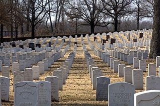
Fort Smith National Cemetery is a United States National Cemetery located at Garland Avenue and Sixth Street in Fort Smith, Sebastian County, Arkansas. It encompasses 22.3 acres (9.0 ha), and as of the end of 2005, had 13,127 interments.

The Fort Smith Trolley Museum is a streetcar and railroad museum in Fort Smith, in the U.S. state of Arkansas, which includes an operating heritage streetcar line. The museum opened in 1985, and operation of its streetcar line began in 1991. Four vehicles in its collection, a streetcar and three steam locomotives, are listed on the National Register of Historic Places (NRHP). The now approximately three-quarters-mile-long (1.2 km) streetcar line also passes four NRHP-listed sites, including the Fort Smith National Historic Site, the Fort Smith National Cemetery, the West Garrison Avenue Historic District and the 1907 Atkinson-Williams Warehouse Building, which now houses the Fort Smith Museum of History.

The Eastside Historic Cemetery District is a historic district bounded by Elmwood Avenue, Mt. Elliott Avenue, Lafayette Street, and Waterloo Street in Detroit, Michigan. The district consists of three separate cemeteries: Mount Elliott Cemetery, Elmwood Cemetery, and the Lafayette Street Cemetery. The district was listed on the National Register of Historic Places in 1982.

U.S. Route 64 is a U.S. route running from Teec Nos Pos, Arizona east to Nags Head, North Carolina. In the U.S. state of Arkansas, the route runs 246.35 miles (396.46 km) from the Oklahoma border in Fort Smith east to the Tennessee border in Memphis. The route passes through several cities and towns, including Fort Smith, Clarksville, Russellville, Conway, Searcy, and West Memphis. US 64 runs parallel to Interstate 40 (I-40) until Conway, when I-40 takes a more southerly route.

This is a list of the National Register of Historic Places listings in Sebastian County, Arkansas.

Birney Safety Streetcar No. 224 is a streetcar in Fort Smith, Arkansas, listed on the U.S. National Register of Historic Places. Built in 1926 by the American Car Company division of the J. G. Brill Company, it is a type of streetcar known as a Birney "Safety Car". It was listed on the National Register in 1994 and is one of fewer than 10 streetcars listed.

Highway 255 is a designation for two north–south state highways in Sebastian County. An eastern route of 7.37 miles (11.86 km) runs north from Highway 22 through Lavaca to terminate at Highway 22 in Central City. A second route of 17.21 miles (27.70 km) begins at Highway 22 in Barling and runs to US Route 64/U.S. Route 71B (US 64/US 71B).

The Benton County Poor Farm Cemetery is a historic cemetery in Bentonville, Arkansas. It is located off NE Young Avenue in a residential subdivision northeast of the city's center. It was established c. 1860, around the time Benton County's poor farm was established, and it was in active use until the poor farm was closed c. 1930. It has a small number of marked graves, and an unknown number of unmarked graves, some of which are distinguishable by the presence of depressions in the ground.

Son's Chapel is a historic church at 5480 East Mission in Fayetteville, Arkansas. It is a single-story rustic fieldstone structure, with front-gable roof and a squat square tower set off to one side. Built between 1933 and 1937, the building is an interesting and unusual mix of Gothic and Romanesque styles, with windows set under Romanesque arches, and the tower with a crenellated parapet. The church is the second for the congregation, which was established c. 1848 on land donated by Michael Son.

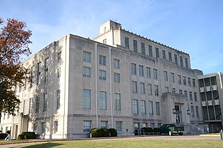
The Sebastian County Courthouse/Fort Smith City Hall is a historic civic building at 100 South 6th Street in Fort Smith, Arkansas. It is a large four-story stone and concrete structure with modest Art Deco styling, designed by Fort Smith architects E. Chester Nelson and Bassham & Wheeler and built in 1937 with funding from the Public Works Administration. Its interior lobby and courthouse spaces are richly decorated, with marble walls, terrazzo marble flooring, and ornamental moldings around doorways. The building continues to house county facilities; the city offices are now located on Garrison Avenue.

The Ft. Smith Confederate Monument stands on the grounds of the Sebastian County Courthouse at the junction of 6th and Rogers Streets in Fort Smith, Arkansas. The statue depicts a Confederate Army soldier, standing facing north, holding the upper stock of his rifle, which is grounded. The sculpture is 6 feet (1.8 m) in height, and is mounted on a square columnar pedestal over 30 feet (9.1 m) tall. The monument was placed in 1903 with funding raised by the local chapter of the Daughters of the Confederacy. An earlier Confederate memorial, placed at Fort Smith National Cemetery, was destroyed by a tornado, and the federal government objected to the placement of this memorial there without alterations to also commemorate the Union dead. The city granted permission for its placement at its current location.

Oak Cemetery is a historic cemetery at Greenwood and Dodson Avenues in Fort Smith, Arkansas. Established in 1853, it is the city's oldest and largest cemetery, and the burial site of many of its most prominent citizens. The cemetery covers 35 acres (14 ha) and is estimated to have more than 11,000 burials. Noted burials include Fort Smith founder John Rogers.

The Cleburne County Farm Cemetery is located at Plantation Drive East and Deer Run in Heber Springs, Arkansas. It is a small cemetery, with seventeen graves, ten of which have markers. It is surrounded by a chain-link fence, and there is a commemorative marker. The cemetery saw active use from 1896 to 1943, and is the only surviving element of the county's poor farm, which was used by the county to provide for its indigent population during that time.
Elmwood-St. Joseph Municipal Cemetery is located in Mason City, Iowa, United States. It was listed as a historic district on the National Register of Historic Places in 2018.


