
Arkadelphia is a city in Clark County, Arkansas, United States. As of the 2020 census, the population was 10,380. The city is the county seat of Clark County. It is situated at the foothills of the Ouachita Mountains. Two universities, Henderson State University and Ouachita Baptist University, are located here. Arkadelphia was incorporated in 1857.
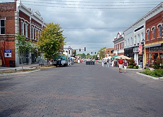
The Rogers Commercial Historic District, known informally as Historic Downtown Rogers, is a historic district in the central business district of Rogers, Arkansas. When it was first listed on the National Register of Historic Places in 1988, it was known as the Walnut Street Historic District; this was changed when the district was enlarged in 1993. The district encompasses a portion of the city's central business district, whose historical significance extends from about 1885 to the end of World War II.

Charles L. Thompson and associates is an architectural group that was established in Arkansas since the late 1800s. It is now known as Cromwell Architects Engineers, Inc.. This article is about Thompson and associates' work as part of one architectural group, and its predecessor and descendant firms, including under names Charles L. Thompson,Thompson & Harding,Sanders & Ginocchio, and Thompson, Sanders and Ginocchio.

The Clark County Library is located at 609 Caddo St. in Arkadelphia, Arkansas. It is located in a Classical Revival single-story brick building designed by Charles L. Thompson, a noted Little Rock architect, and built in 1903. It is one of the oldest institutional library buildings in Arkansas. It was built by the local Women's Library Association, and transferred to county control in 1974.
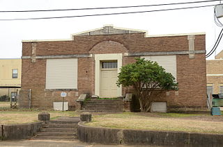
The Domestic Science Building is a historic school building at 11th and Haddock in Arkadelphia, Arkansas. It was on the old campus of Arkadelphia High School, used for domestic science courses until the 1980s. It is now unused, but remains the property of the Arkadelphia School District.
The Monticello Commercial Historic District encompasses a portion of the historic business district of Monticello, the seat of Drew County, Arkansas. The district was listed on the National Register of Historic Places in 2011.
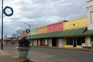
The Lake Village Commercial Historic District encompasses the historic commercial heart of Lake Village, Arkansas, the county seat of Chicot County in the Mississippi River delta region of southeastern Arkansas. The district covers about six square blocks of downtown Lake Village, bounded roughly by Jackson Street to the north, Lakeshore Drive to the east, Church Street to the south, and Chicot Street to the west. This area represents the growth of Lake Village during its period of greatest prosperity, between 1906 and 1960. The city's growth was spurred by the arrival of the railroad in 1903, and most of the district's buildings were built between 1900 and 1930. Most of the buildings are vernacular commercial buildings; the John Tushek Building at 202 Main Street is one interesting example of Beaux Arts styling, and 218–222 Main Street has some Italianate styling. The district includes the Lake Village Confederate Monument, which has been a local landmark since 1910.
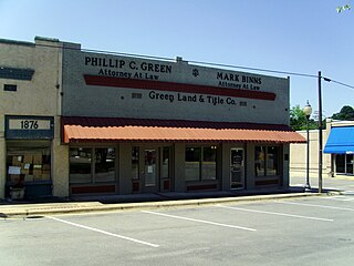
The Star City Commercial Historic District encompasses the historic commercial center of Star City, Arkansas, the county seat of Lincoln County. The district consists of thirteen buildings on two city blocks, as well as the Star City Confederate Memorial. The buildings are located on Jefferson Street, between Arkansas and Bradley Streets, and on Bradley Street between Jefferson and Drew Streets. The memorial is located in the town square, near the junction of Jefferson and Bradley. The buildings in the district were built between 1916 and 1928, and have for the most part escaped major alterations since their construction. Minor changes generally involve changes to store fronts, such as the boarding over of transom windows, the replacement of recessed entries with flush ones, and changes to the fenestration. The building at 108 Jefferson, built in 1927 to house a bar, has been extensively remodeled and does not contribute to the district's significance; the Star Theater building at 212-214 Bradley has also been extensively altered.

The Fordyce Commercial Historic District encompasses the historic heart of Fordyce, Arkansas, the county seat of Dallas County. It encompasses four city blocks of North Main Street, between 1st and 4th, and includes properties on these adjacent streets. Fordyce was founded in 1882, and the oldest building in the district, the Nutt-Trussell Building at 202 North Main Street, was built c. 1884. Spurred by the logging industry and the Cotton Belt Railroad, Fordyce's downtown area had 25 buildings by 1901, and continued to grow over the next few decades, resulting in a concentration of period commercial architecture in its downtown. The district was listed on the National Register of Historic Places in 2008.

The James E. M. Barkman House is a historic house located at 406 North 10th Street in Arkadelphia, Arkansas.

The Bozeman House is a historic house in rural Clark County, Arkansas. It is located on the north side of Arkansas Highway 26, several miles west of Arkadelphia, the county seat. It is a 1+1⁄2-story wood-frame house with Greek Revival styling. The house was built c. 1847 by Michael Bozeman, one of the county's early settlers, and is one of the oldest structures standing in the county. The main block is five bays wide, with a pedimented portico above the entrance on the southern facade. A kitchen ell extends to the rear of the house from the northwestern corner, giving the house an L-shape. The roof the main facade is pierced by a pair of gabled dormers. The trim detailing includes entablatures and dentil moulding.
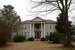
The Hudson-Jones House is a historic house in rural Clark County, Arkansas. It is located on County Road 68, north of its junction with County Road 34, about 10 miles (16 km) east of Arkadelphia, on a 12-acre (4.9 ha) parcel of farmland. It is a handsome Greek Revival structure, 2+1⁄2 stories tall, with a single-story addition to the rear. Its most distinctive feature is a full Greek Revival portico with triangular pediment, supported by paired columns. The house was built c. 1840, and survives with most of its outbuildings intact.
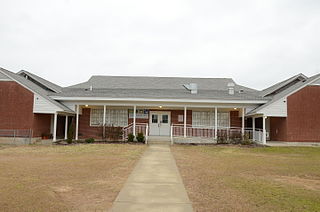
The Peake High School is a historic school building at 1600 Caddo Street in Arkadelphia, Arkansas. This H-shaped single-story brick building was built in 1929 with assistance from the Rosenwald Fund on land given by J. Ed Peake, a school principal for whom the school was named. The building was used as a high school for African Americans until 1960, when a new building was constructed adjacent to this one, which was converted to an elementary school. The city's public schools were integrated in 1969. The school housed the city's Head Start Program from 1984 to 2001. It is the only surviving Rosenwald school in the county.
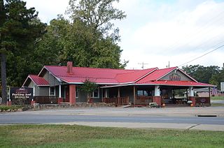
The C. E. Thompson General Store and House is a historic property at 3100 Hollywood Road in Arkadelphia, Arkansas. Its principal structure is a single-story wood-frame with a gable roof, which was built in 1936 and served as a residence for the Thompson family and as a general store until it closed in the 1980s. It is the only Craftsman-style general store building in Arkadelphia. The building currently houses Allen's Barbeque, a local barbeque restaurant. The property includes other historically significant buildings, including a garage, wellhouse, privy, shed, smokehouse, and barn.

The DeQueen Commercial Historic District encompasses part of the commercial heart of downtown De Queen, Arkansas. The district is centered on the block containing the Sevier County Courthouse, a three-story brick Colonial Revival structure built in 1930. It includes buildings facing the courthouse square on West DeQueen Avenue, West Stilwell Avenue, and North Third Street, and extends an additional block eastward to North Second Street. This commercial heart of the city was developed mainly between 1900 and 1920, and includes 21 historically significant buildings. Notable among them is the former Hayes Hardware Building at 314 West DeQueen, built c. 1900, and the Bank of DeQueen at 221 West DeQueen, also built c. 1900.

The Nashville Commercial Historic District encompasses much of the historic downtown commercial area of Nashville, Arkansas, and the major commercial center in Howard County. It is centered at the junction of Main and Howard Streets, extending eastward along East Howard, and north and south along Main Street for about one block. Most of the buildings in the district are tall single-story brick structures, some covered in stucco. They were built between about 1895 and the 1930s, with a smaller number appearing later. The area's economic activity was driven first by the arrival of the railroad, which defined the layout of the town, and then by the growth of lumber and agriculture in the region. The oldest building in the district is 203 North Main, built c. 1895 with modest Romanesque Revival styling.

The Lepanto Commercial Historic District encompasses the traditional commercial heart of the small city of Lepanto, Arkansas. The district includes one block of Greenwood Avenue between Berry and Holmes Streets, and portions of two more blocks at either end, as well as two blocks of Berry Street, with a few buildings on adjacent streets. Lepanto was founded in 1903, but its surviving commercial architecture only dates as far back as c. 1915, when the Portis Company cotton gin was built at the eastern end of the district. Other early buildings include the triangular c. 1920 Arlington Light and Power building at 320 Greenwood, and the unusual Barton's of Lepanto building at 111 Berny Street, built as a wood frame lumber yard office c. 1920; its walls were bricked in 1955 when it was converted to a hardware store.
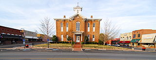
The Pocahontas Commercial Historic District encompasses the historic civic heart of Pocahontas, the county seat of Randolph County, Arkansas. The district includes roughly five-block stretches of Broadway and Pyburn and Everett Streets between US 67 and Bryant Street, and extends across US 67 to include a small complex of industrial buildings and the former railroad depot. Founded in 1836, the center of Pocahontas is dominated by the Old Randolph County Courthouse, a handsome Italianate structure built in 1875 which now houses city offices. It is surrounded by commercial buildings, generally one or two stories in height, most of which were built between 1900 and 1930, although there are a few 19th-century buildings. Later growth extended away from this center. Other notable buildings in the district include the present Randolph County Courthouse and the 1930s Art Deco style Post Office building.

The Canal Street–Clark Street Neighborhood Historic District encompasses a compact 19th-century working-class neighborhood of Brattleboro, Vermont. Most of its buildings are modest vernacular wood-frame buildings, erected between 1830 and 1935; there are a few apartment blocks, and one church. The district was listed on the National Register of Historic Places in 1993.

Highway 51 is a designation for two north–south state highways in Southwest Arkansas. One route of 53.37 miles (85.89 km) begins Highway 53 near Whelen Springs and runs north to US Highway 67 in Donaldson. A second route of 7.92 miles (12.75 km) runs parallel to US 270 northwest of Malvern. Both routes are maintained by the Arkansas Department of Transportation (ArDOT).


