Highway 22 is an east–west state highway in the Arkansas River Valley. The highway runs 75.60 miles (121.67 km) from US 64/US 71B east to Highway 7 in Dardanelle. The highway is one of the original 1926 state highways, and is maintained by the Arkansas State Highway and Transportation Department (AHTD).

State Road 2 is a former east–west state highway in the Arkansas Timberlands and Lower Arkansas Delta. The route was approximately 195 miles (314 km), and ran from US Route 67 (US 67) in Texarkana east to cross the Mississippi River near Lake Village, continuing as Mississippi Highway 10. On July 1, 1931, the route was entirely replaced by US Highway 82 (US 82) by the American Association of State Highway Officials (AASHTO). The route was maintained by the Arkansas Highway Department (AHD), now known as the Arkansas Department of Transportation (ArDOT).

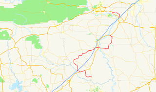
Highway 319 is a designation for two state highways in central Arkansas. The main segment runs 18.01 miles (28.98 km) from AR 38 in Ward to AR 107 south of Vilonia. A short segment runs 1.65 miles (2.66 km) from Cadron Settlement Park to US 64 in Conway.

U.S. Route 67 is a U.S. highway running from Presidio, Texas northeast to Sabula, Iowa. In the U.S. state of Arkansas, the route runs 279.15 miles (449.25 km) from the Texas border in Texarkana northeast to the Missouri border near Corning. The route passes through several cities and towns, including Hope, Benton, Little Rock, Jacksonville, Cabot, Beebe, Walnut Ridge, and Pocahontas.

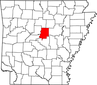
Arkansas Highway 365 is a north–south state highway in Central Arkansas. The route of 69.31 miles (111.54 km) runs from US 65B/US 79B in Pine Bluff north through Little Rock to US 65B/AR 60 in Conway. The route is a redesignation of former U.S. Route 65, which has since been rerouted onto various Interstate highways through the area. Portions of Highway 365 in Jefferson County are former alignments of the Dollarway Road, which was the longest paved concrete road upon completion in 1913.

Highway 190 is a designation for four state highways in Arkansas. Three are low-traffic rural highways in Grant County, with one designation along city streets in Pine Bluff. The rural segments were created in 1965 and 1966, with the Pine Bluff section created in 2000. All segments are maintained by the Arkansas Department of Transportation (ARDOT).
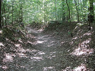
The Memphis to Little Rock Road-Village Creek Segment is a historic military road in Cross County, Arkansas. Located entirely within Village Creek State Park, this 1.5-mile (2.4 km) segment of roadway is one of the best-preserved portions of the military road built between Memphis, Tennessee and Little Rock, Arkansas in 1828. This road is notable for the large numbers of westward-traveling pioneers who used it en route to settling the American Plains, and for its use in the forced migration of several Native American tribes in the 1830s. The roadway portion, in parts set in dramatically deep cuts in the hills, extends from Village Creek in the east to the western boundary of the park, and is accessible today as a hiking trail.
The Memphis to Little Rock Road-Strong's Ferry Segment is a historic military road in eastern Cross County, Arkansas. This segment of roadway is one of the best-preserved portions of the military road built between Memphis, Tennessee and Little Rock, Arkansas in 1828. This road is notable for the large numbers of westward-traveling pioneers who used it en route to settling the American Plains, and for its use in the forced migration of several Native American tribes in the 1830s. This roadway portion extends from the site of a former ferry crossing on the St. Francis River, westward toward Village Creek State Park, where there is another surviving segment that is hikable.

The Memphis to Little Rock Road-Henard Cemetery Road Segment is a section of historic roadway in Monroe County, Arkansas. It consists of 650 metres (2,130 ft) of the middle of Henard Cemetery Road, located northeast of the hamlet of Zent in the far northeastern part of the county. The roadway section is one of three known places where the original 19th-century appearance of the first road to connect Memphis, Tennessee to Little Rock, Arkansas is preserved. The far ends of the road have been impacted by development and agriculture, and do not convey the sense of the road's early appearance. The road is also historically important as it was used as part of the Trail of Tears, the forced removal of Native Americans east of the Mississippi River to what is now Oklahoma.
The Memphis to Little Rock Road-Bayou Two Prairie Segment is a historic military road section in Lonoke County, Arkansas. Located north of Lonoke near the hamlet of Brownsville, the road section was part of the 1828 Memphis to Little Rock Military Road. It was used in the 1830s during the Trail of Tears removal of eastern Native American tribes, and was used by military forces on both sides of the American Civil War leading up to the Battle of Brownsville.
The Memphis to Little Rock Road-Brownsville Segment is a historic military road section in Lonoke County, Arkansas. Located north of Lonoke near the hamlet of Brownsville, the road section was part of the 1828 Memphis to Little Rock Military Road. It was used in the 1830s during the Trail of Tears removal of eastern Native American tribes, and was used by military forces on both sides of the American Civil War leading up to the Battle of Brownsville.

The Blessing Homestead is a historic farmstead in rural northeastern Faulkner County, Arkansas. It is located overlooking the west bank of East Fork Cadron Creek, on Happy Valley Road east of County Road 225E, between McGintytown and Centerville. The central feature of the homestead is a dogtrot house, with one pen built of logs and the other of wood framing. The log pen was built about 1872, and typifies the evolutionary growth of these kinds of structures. It is the only remaining structure associated with the early history of Barney, most of which was wiped out by a tornado in 1915.

Cadron Settlement Park is a 150-acre public park located in Conway, Arkansas. The park is operated by the city of Conway under a lease from the United States Army Corps of Engineers. It was established on October 14, 1979, and features a reconstructed blockhouse, a boat launching ramp, hiking trails, restrooms, picnic areas, pavilion, handicapped trails and parking areas, and interpretive signs. The Faulkner County Historical Society hosts public events in the blockhouse.
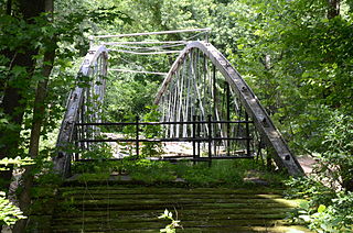
The Springfield Bridge is a historic bowstring truss bridge, located in Beaverfork Lake Park in Conway, Arkansas, USA. It originally spanned Cadron Creek in rural Faulkner County east of Springfield. It is 188 feet (57 m) long, set on stone abutments, with tubular metal top chords that rise 15 feet (4.6 m) above the bottom chords. Built circa 1871–74, it is the oldest documented highway bridge in the state and its only documented bowstring arch bridge.

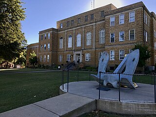
The Titan II ICBM Launch Complex 374-5 Site is a historic military installation in rural Faulkner County, Arkansas. It is located roughly midway between Greenbrier and Conway, on the east side of United States Route 65 about 0.4 miles (0.64 km) north of its junction with East Cadron Ridge Road. It is an underground complex on 10 acres (4.0 ha) of land, featuring a missile silo and launch control facility. Its ground-level access points have been back-filled with rubble or welded shut, and are discernible only by the presence of concrete pads and mounds of earth. Surface features also include the remnants of a helicopter pad and a theodolite siting marker, and the original access road to the facility from US 65. The facility was staffed by the 374th Strategic Missile Squadron between 1963 and 1986, housing an LGM-25C Titan II ICBM, and was decommissioned and rendered non-functional in 1987 under the terms of the SALT II strategic arms treaty.
The Little Rock to Cantonment Gibson Road-Old Wire Road Segment is a historic road section in Conway County, Arkansas. It consists of a section of Old Wire Road, southwest of the hamlet of Blackwell, which is about 300 metres (980 ft) long and 18 feet (5.5 m) wide. It is defined in part by the cut through which it passes, with steep banks on either side. Built in 1827, it is one of the oldest surviving road alignments of the military road built between Little Rock, and what is now Fort Gibson in Oklahoma. This route formed part of the Trail of Tears, the historic removal of Native Americans to the Indian Territory that is now Oklahoma.
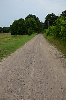
The Little Rock to Cantonment Gibson Rd-Fourth Street Segment is a history stretch of 19th-century roadbed in rural Pope County, Arkansas. It consists of about one mile of gravel roadway, now designated Fourth Street, east of Atkins, extending from Union Grove Loop in the west to Oakland Drive in the east. It is about 18 feet (5.5 m) wide, and is built on an embankment for much of its length. Completed by early 1828 as a military road connecting Little Rock to what is now Fort Gibson in Oklahoma, the road is historically significant for its use as part of the Trail of Tears removal of eastern Native Americans to the Indian Territory that is now Oklahoma.

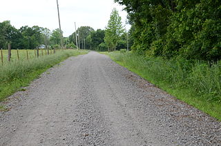
The Little Rock to Cantonment Gibson Road-Short Mountain Segment is a historic 19th-century road section in Logan County, Arkansas. It is located northwest of Paris, consisting of 3.7 miles (6.0 km) of Short Mountain Road, extending westward from its crossing with Short Mountain Creek. The roadbed is about 12 feet (3.7 m) wide, and is heavily banked for much of its length. Built in 1828, it was originally part of the military road connecting Little Rock, Arkansas to what is now Gibson, Oklahoma. The road has been documented to be part of the Trail of Tears migration route.
Highway 51 is a designation for two north–south state highways in Southwest Arkansas. One route of 53.37 miles (85.89 km) begins Highway 53 near Whelen Springs and runs north to US Highway 67 in Donaldson. A second route of 7.92 miles (12.75 km) runs parallel to US 270 northwest of Malvern. Both routes are maintained by the Arkansas Department of Transportation (ArDOT).
Highway 36 is a state highway in Central Arkansas. The highway begins at U.S. Highway 64 (US 64) at Hamlet and runs east through several small communities and briefly overlaps with US 64/US 67/US 167 before state maintenance ends at the small community of Georgetown. This highway is maintained by the Arkansas Department of Transportation (ARDOT).