NHLs in Alaska
The table below lists all of the National Historic Landmark sites, along with added detail and description.
| [4] | Landmark name | Image | Date designated [5] | Location | County | Description |
|---|---|---|---|---|---|---|
| 1 | Adak Army Base and Adak Naval Operating Base |  | February 27, 1987 (#87000841) | Adak Station 51°52′19″N176°38′10″W / 51.872°N 176.636°W | Aleutians West | Established in 1942 as part of World War II, this military base was the launching pad for the American attack on the Japanese-held Aleutian Islands of Kiska and Attu. |
| 2 | Alaska Native Brotherhood Hall |  | June 2, 1978 (#72000192) | 235 Katlian Street, Sitka 57°03′03″N135°20′28″W / 57.0507°N 135.34099°W | Sitka | This 1914 meeting hall and headquarters building served the original chapter of Alaska Native Brotherhood, founded by Tlingits in the early 1900s to fight discrimination and represent interests of natives. |
| 3 | Amalik Bay Archeological District |  | April 5, 2005 (#05000460) | Address restricted [6] , Katmai National Park and Preserve | Kodiak Island | An archeological site located in Kodiak Island Borough |
| 4 | American Flag Raising Site | 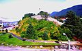 | June 13, 1962 (#66000162) | On Castle Hill, Sitka 57°02′55″N135°20′16″W / 57.0487°N 135.33783°W | Sitka | In 1867, site of Russian flag lowering and American flag raising marking the transfer of Alaska to the U.S.; in 1959, after Alaska admitted as 49th state, site of first official raising of 49-star U.S. flag; also known as Castle Hill and Baranof Castle. |
| 5 | Anangula Site |  | June 2, 1978 (#78000512) | Nikolski 53°00′02″N168°54′40″W / 53.00056°N 168.91111°W | Aleutians West | Site of earliest signs of human occupation in the Aleutian Islands. |
| 6 | Attu Battlefield and U.S. Army and Navy Airfields on Attu |  | February 4, 1985 (#85002729) | Attu Island 52°54′02″N172°54′34″E / 52.9005°N 172.9094°E | Aleutians West | Site of bloody battle in which only 29 of 2,500 Japanese survived, only land battle on U.S. soil during World War II. |
| 7 | Bering Expedition Landing Site |  | June 2, 1978 (#77001542) | On Kayak Island 59°53′40″N144°29′08″W / 59.89444°N 144.48556°W | Valdez-Cordova | Site of first recorded contacts between natives and Europeans |
| 8 | Birnirk Site |  | December 29, 1962 (#66000953) | Address restricted [6] , Barrow | North Slope | Sixteen prehistoric mounds of the Birnirk and Thule cultures. |
| 9 | Brooks River Archeological District |  | April 19, 1993 (#78000342) | Address restricted [6] , Katmai National Park and Preserve | Lake and Peninsula | An archaeological site located along an ancient beach and modern river. There are twenty separate well preserved sites which have provided a large number of Arctic Small Tool Tradition artifacts. |
| 10 | Cape Krusenstern Archeological District |  | November 7, 1973 (#73000378) | Address restricted [6] , Kotzebue | Northwest Arctic | The archeological district comprises 114 ancient beach ridges which formed nearly 60 years apart. They provide a rare sequential look at over 5000 years of inhabitation. |
| 11 | Cape Nome Mining District Discovery Sites |  | June 2, 1978 (#78000535) | Nome 64°33′49″N165°22′17″W / 64.56361°N 165.37139°W | Nome | Significant for role in the history of gold mining in Alaska |
| 12 | Chaluka Site |  | December 29, 1962 (#66000155) | Address restricted [6] , Nikolski | Aleutians West | Includes a large mound; yields information about origins of Aleuts |
| 13 | Chilkoot Trail and Dyea Site |  | June 16, 1978 (#75002120) | Skagway 59°35′14″N135°19′56″W / 59.58719°N 135.33234°W | Skagway | Major access route from the coast to Yukon goldfields in the late 1890s. |
| 14 | Church of the Holy Ascension |  | April 15, 1970 (#70000112) | Unalaska 53°52′33″N166°32′11″W / 53.8758°N 166.5363°W | Aleutians West | Built in 1826 by the Russian American Fur Company to help acclimate indigenous population in Russian Alaska. |
| 15 | Dry Creek Archeological Site |  | June 2, 1978 (#74000442) | Address restricted [6] , near Healy, Alaska | Denali | This archeological site has provided evidence which supports the Bering land bridge theory |
| 16 | Dutch Harbor Naval Operating Base and Fort Mears, U.S. Army |  | February 4, 1985 (#85002733) | Unalaska 53°53′16″N166°32′23″W / 53.8878°N 166.5397°W | Aleutians West | Only U.S. fortifications in the Aleutian Islands prior to bombing of Pearl Harbor, attacked by the Japanese Navy during the Battle of Dutch Harbor in June 1942. |
| 17 | Eagle Historic District |  | June 2, 1978 (#70000919) | Eagle 64°47′10″N141°12′00″W / 64.7861°N 141.2°W | Southeast Fairbanks | Historic district with over 100 well-preserved buildings from the Gold Rush years on the Yukon River. Roald Amundsen announced his successful traverse of the Northwest Passage from here in 1905 |
| 18 | Fort Durham Site | June 2, 1978 (#78000529) | Address restricted [6] , near Taku Harbor in Juneau City and Borough, Alaska | Juneau | One of three Hudson's Bay Company posts set up in Alaska | |
| 19 | Fort Glenn |  | May 28, 1987 (#87001301) | Fort Glenn 53°22′39″N167°53′24″W / 53.37750°N 167.89000°W | Aleutians West | Well preserved World War II defense base. |
| 20 | Fort William H. Seward |  | June 2, 1978 (#72000190) | Haines 59°13′36″N135°26′41″W / 59.2267°N 135.4446°W | Haines | Last of a series of 11 military posts established in Alaska during the gold rush era |
| 21 | Gallagher Flint Station Archeological Site |  | June 2, 1978 (#78003208) | Address restricted [6] , Sagwon | North Slope | Discovered in 1970 during the construction of the Trans-Alaska Pipeline, it was at the time the earliest dated archaeological site in northern Alaska. |
| 22 | Holy Assumption Orthodox Church |  | April 15, 1970 (#70000898) | Kenai 60°33′11″N151°16′03″W / 60.55295°N 151.2675°W | Kenai Peninsula | Russian Orthodox church in Kenai, Alaska. |
| 23 | Ipiutak Site |  | January 20, 1961 (#66000157) | Address restricted [6] , Point Hope Peninsula | North Slope | The type site for the Ipiutak culture |
| 24 | Iyatayet Site |  | January 20, 1961 (#66000158) | Address restricted [6] , Cape Denbigh Peninsula | Nome | Shows evidence of several separate cultures, dating back as far as 6000 BC. |
| 25 | Kake Cannery |  | December 9, 1997 (#97001677) | About 1 mile (1.6 km) southwest of Kake 56°57′53″N133°55′32″W / 56.96471°N 133.9255°W | Prince of Wales-Hyder | Built 1912-1940; significant for role in history of salmon canning in Alaska |
| 26 | Kennecott Mines |  | June 23, 1986 (#78003420) | East of Kennicott Glacier, about 6.5 miles (10.5 km) north of McCarthy 61°31′09″N142°50′29″W / 61.51909°N 142.84149°W | Valdez-Cordova | Site of discovery of copper in 1900 and subsequent mining activities |
| 27 | Kijik Archeological District |  | October 12, 1994 (#94001644) | Address restricted [6] , Lake Clark National Park and Preserve | Lake and Peninsula | Related to the history of the Dena'ina Athabaskan Indians |
| 28 | Japanese Occupation Site, Kiska Island |  | February 4, 1985 (#85002732) | Kiska Island 51°58′02″N177°29′31″E / 51.9672°N 177.4919°E | Aleutians West | Site of the Japanese occupation of Kiska which along with nearby Attu were the only US land occupied by the Japanese during World War II |
| 29 | Kodiak Naval Operating Base and Forts Greely and Abercrombie |  | February 4, 1985 (#85002731) | Kodiak 57°44′19″N152°30′17″W / 57.73861°N 152.50472°W | Kodiak Island | World War II-related facilities |
| 30 | Ladd Field |  | February 4, 1985 (#85002730) | Fairbanks 64°50′15″N147°36′52″W / 64.8375°N 147.6144°W | Fairbanks North Star | Primary role during WWII was major stopping point for the Lend-Lease program. |
| 31 | Leffingwell Camp Site |  | June 2, 1978 (#71001093) | On Flaxman Island, about 58 miles (93 km) west of Kaktovik 70°11′07″N146°03′10″W / 70.1852°N 146.05287°W | North Slope | Campsite of geologist and polar explorer Ernest de Koven Leffingwell on Arctic coast of Alaska. |
| 32 | Nenana (river steamboat) |  | May 5, 1989 (#72001581) | Pioneer Park, Fairbanks 64°50′19″N147°46′20″W / 64.8386°N 147.77236°W | Fairbanks North Star | River steamboat; only surviving wooden one of this type. |
| 33 | New Russia Site | June 2, 1978 (#72001593) | South of Kardy Lake, about 3.5 miles (5.6 km) southwest of Yakutat 59°31′37″N139°49′36″W / 59.52694°N 139.82662°W | Yakutat | Site of Russian trading post attacked and destroyed by Tlingit natives. | |
| 34 | Old Sitka |  | June 13, 1962 (#66000166) | Mile 6.9 of Halibut Point Road, about 6 miles (9.7 km) north of Sitka 57°07′46″N135°22′24″W / 57.12955°N 135.37342°W | Sitka | Also known as the Redoubt St. Archangel Michael Site, this was the site of a Russian-American Company settlement, established in 1799 and destroyed by Tlingit attack in 1802. |
| 35 | Onion Portage Archeological District |  | June 2, 1978 (#72000191) | Address restricted [6] , Kiana | Northwest Arctic | Perhaps most important archaeological site in Alaska; caribou river crossing; human presence for millennia. |
| 36 | Palugvik Site | December 29, 1962 (#66000957) | Address restricted [6] , Hawkins Island | Valdez-Cordova | Includes a large midden yielding information about Eskimo culture in the area. | |
| 37 | Russian-American Building No. 29 |  | May 28, 1987 (#87001282) | 202-206 Lincoln Street, Sitka 57°02′59″N135°20′11″W / 57.04965°N 135.33629°W | Sitka | Siding covered log building; dates back to the years after the 1867 purchase of Alaska. |
| 38 | Russian-American Magazin |  | June 13, 1962 (#66000954) | 101 East Marine Way, Kodiak 57°47′16″N152°24′12″W / 57.78765°N 152.40338°W | Kodiak Island | Storehouse building associated with the Russian and then the American trading companies active in Alaska. |
| 39 | Russian Bishop's House | 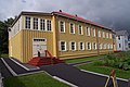 | June 13, 1962 (#66000025) | 501 Lincoln Street, Sitka 57°03′05″N135°19′52″W / 57.05147°N 135.33101°W | Sitka | One of four surviving examples of Russian Colonial Style architecture in the Western Hemisphere. |
| 40 | St. Michael's Cathedral | 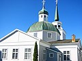 | June 13, 1962 (#66000165) | 240 Lincoln Street, Sitka 57°03′00″N135°20′06″W / 57.05008°N 135.33512°W | Sitka | Primary evidence of Russian influence in North America. |
| 41 | Seal Island Historic District | 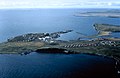 | June 13, 1962 (#66000156) | Pribilof Islands 57°N170°W / 57°N 170°W | Aleutians West | Historic buildings related to northern fur seal hunting in the Pribilof Islands and its restriction in 1911 and 1966. |
| 42 | Sheldon Jackson School |  | August 7, 2001 (#72000193) [a] | 801 Lincoln Street, Sitka 57°03′03″N135°19′25″W / 57.0509°N 135.32357°W | Sitka | Oldest institution of higher learning in Alaska |
| 43 | Sitka Naval Operating Base and U.S. Army Coastal Defenses |  | August 11, 1986 (#86003559) | Japonski Island, Makhnati Island and the causeway connecting them, near Sitka 57°02′58″N135°21′35″W / 57.04941°N 135.35963°W | Sitka | Commissioned as Sitka Naval Air Station in October 1939, it was redesignated the Naval Operating Base, July 1942. Protected the North Pacific during World War II. [7] |
| 44 | Sitka Spruce Plantation |  | June 2, 1978 (#78000513) | Unalaska 53°53′12″N166°32′23″W / 53.8866°N 166.5397°W | Aleutians West | First recorded afforestation project in North America; Russian settlers began in 1805; attempt to make Unalaska self-sufficient in timber. |
| 45 | Skagway Historic District and White Pass |  | June 13, 1962 (#66000943) | Skagway and White Pass 59°27′30″N135°18′50″W / 59.4583°N 135.3139°W | Skagway | Historic frontier Gold Rush town and trail leading to White Pass on the border of Canada. Over 100 buildings from the era survive, though they are threatened by continued development. Mentioned in The Call of the Wild by Jack London. |
| 46 | George C. Thomas Memorial Library |  | June 2, 1978 (#72001542) | Fairbanks 64°50′41″N147°43′40″W / 64.844735°N 147.727652°W | Fairbanks North Star | The public library for Fairbanks from its construction in 1909 until the opening of the Noel Wien Public Library in 1977. Site of 1915 meeting between U.S. officials and native Alaskans to settle land claims. |
| 47 | Three Saints Bay Site | 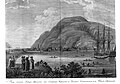 | June 2, 1978 (#72001541) | Address restricted [6] , Old Harbor | Kodiak Island | Site of the first Russian settlement in Alaska in 1784. |
| 48 | Wales Site |  | December 29, 1962 (#66000161) | Address restricted [6] , Wales | Nome | Site of first discovery of how the Thule culture followed the Birnirk culture in precontact whaling populations of the Alaskan shoreline. |
| 49 | Walrus Islands Archeological District |  | December 23, 2016 (#100000875) | mouth of Bristol Bay 58°36′42″N159°59′27″W / 58.611633°N 159.990909°W | Dillingham Census Area, Alaska | Island group with deeply stratified sites covering 6,000 years of human occupation. |
| 50 | Yukon Island Main Site |  | December 29, 1962 (#66000955) | Address restricted [6] , Yukon Island | Kenai Peninsula | Related to the Kachemak Bay Culture. |


