
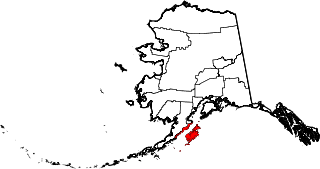
Katmai National Park and Preserve is an American national park and preserve in southwest Alaska, notable for the Valley of Ten Thousand Smokes and for its brown bears. The park and preserve encompass 4,093,077 acres, which is between the sizes of Connecticut and New Jersey. Most of the national park is a designated wilderness area. The park is named after Mount Katmai, its centerpiece stratovolcano. The park is located on the Alaska Peninsula, across from Kodiak Island, with headquarters in nearby King Salmon, about 290 miles (470 km) southwest of Anchorage. The area was first designated a national monument in 1918 to protect the area around the major 1912 volcanic eruption of Novarupta, which formed the Valley of Ten Thousand Smokes, a 40-square-mile (100 km2), 100-to-700-foot-deep pyroclastic flow. The park includes as many as 18 individual volcanoes, seven of which have been active since 1900.

Naknek Lake is a lake in southern Alaska, near the base of the Alaska Peninsula. Located in Katmai National Park and Preserve, the lake is 40 miles (64 km) long and three to eight miles wide, the largest lake in the park. The lake drains west into Bristol Bay through the Naknek River. The elevation of the lake has lowered over the past 5,000 years as it has cut through a glacial moraine, separating Naknek Lake and Brooks Lake and creating Brooks Falls about 3500 years ago.

The Amalik Bay Archeological District is a geographic area with a significant number of archaeological sites in Alaska. It is located on the Pacific coast of Katmai National Park and Preserve, in the mainland portion of Kodiak Island Borough, Alaska.

The Brooks River Archaeological District encompasses a large complex of archaeological sites along the banks of the Brooks River in Katmai National Park and Preserve in the U.S. state of Alaska. It includes at least twenty separate settlement sites with documented occupation dates from 2500 BCE to recent (post-contact) history. It was declared a National Historic Landmark in 1993. The site is partly occupied by the Brooks Camp, one of the major visitor areas of the park.
This is a list of the National Register of Historic Places listings in Kodiak Island Borough, Alaska.
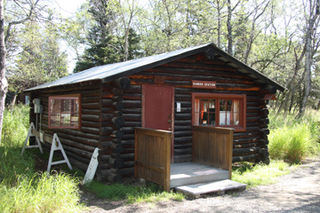
The Brooks Camp Boat House is a historic boathouse at Brooks Camp, a major visitor site in Katmai National Park and Preserve, located on the Alaska Peninsula of southwestern Alaska. The boat house is a simple rectangular log structure with large double-leaf door on the water side, and a door and window on the land side. It was built in 1959 by the National Park Service, and is the second building built in the park by the Park Service. It is used as a ranger station.
This is a list of the National Register of Historic Places listings in Katmai National Park and Preserve.

The Woodchopper Roadhouse, on the Yukon River, is a historic establishment that was built in approximately 1910. It is located in the Yukon-Charley Rivers National Preserve. It served as a hotel and as a post office. Its log building was listed on the National Register of Historic Places in 1987.

Fure's Cabin is a historic 15-by-20-foot log cabin that was built in c.1926. It is located on a narrow isthmus, on the portage trail between Naknek Lake and Lake Grosvenor in Katmai National Park and Preserve on the Alaska Peninsula in the US. Also known as Roy Fure's Trapping Cabin, it was listed on the National Register of Historic Places in 1985; the listing included three contributing buildings and one other contributing structure.

The DIL-161 Site is a prehistoric archeological site in Katmai National Park and Preserve. Located on the banks of the Alagnak River, the site was first identified in 1997 by National Park Service personnel, and its extents were mapped in 2004. The site is that of a village that was occupied between about 300 BCE and 800 CE. More than 40 cabin sites, which are little more than house pits, have been identified.
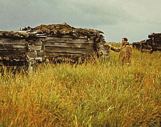
The Old Savonoski Site is the former site of a native village in Lake and Peninsula Borough, Alaska, that was buried by ash in the June 1912 eruption of the Novarupta Volcano. The site is located near the confluence of the Savonoski and Ukak Rivers, and is within the bounds of the Katmai National Park and Preserve. The site was visited by archaeologists in 1953, who identified a number of surviving elements, including fifteen barabaras, or semi-subterranean dwellings.
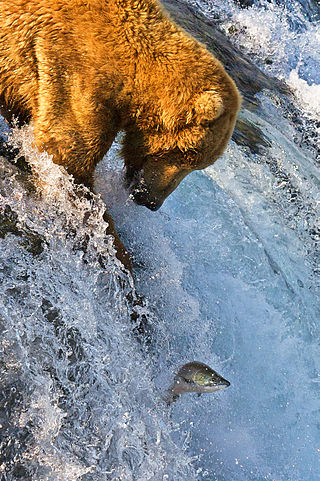
Brooks Camp is a visitor attraction and archeological site in Katmai National Park and Preserve, noted for its opportunities for visitors to observe Alaskan brown bears catching fish in the falls of the Brooks River during salmon spawning season. Famous for its Fat Bear Week, where hundred of thousand observers watch the week long event. The Brooks River connects Lake Brooks and Naknek Lake over about 2 kilometres (1.2 mi). The natural bottleneck for salmon migrations rendered it a desirable site for ancient Alaskans, who inhabited the region around 4500 BP. In the past, the Aglegmuit people inhabited the Brooks River area. The Brooks River Archeological District, which includes Brooks Camp, was designated a National Historic Landmark in 1993.

The Chicken Historic District encompasses part of the historic mining district of Chicken, Alaska. It is located at milepost 66.5 on the north side of the Taylor Highway, and includes fifteen buildings built between 1908 and 1967. Most of these are single-story wood-frame structures, with either metal or board-and-batten siding, although there are also some log structures. Many of these buildings were erected by the Fairbanks Exploration Company, which ran the gold mining operations in the area. Notable buildings include the bunkhouse, a gabled log structure, and the Chicken Creek Roadhouse, built in 1906, which was originally two stories in height but was reduced to a single story in 1924. The district also includes a section of water pipeline built by the company to bring water to the area from Mosquito Creek, a distance of about 1 mile (1.6 km). The camp was used until the company ended mining operations in 1967.
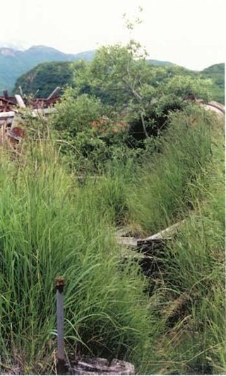
The Kukak Bay Cannery was a commercial razor clam canning operation on the southern coast of the Alaska Peninsula. The cannery operated intermittently from 1922 to 1951, with its most active years before 1936, when most of its complex was destroyed by fire.
The Kaguyak Village Site, designated 49 Afg 4, is a historic and prehistoric archaeological site on the Pacific coast of the Alaska Peninsula in Katmai National Park and Preserve. It is the site of an Alaska Native village which was abandoned after the eruption of Novarupta in 1912. The historic elements of the site include the remains of a Russian Orthodox church and cemetery, as well as a number of frame house remnants and foundations.
Takli Island is an island off the southern coast of the Alaska Peninsula in the Shelikof Strait of southwestern Alaska. It is located at the mouth of Amalik Bay, off the mainland portion of Kodiak Island Borough, in Katmai National Park and Preserve. The area was first archaeologically investigated in the 1960s, when the prehistory of the area was little known, and the island's sites are type sites for a series of archaeological cultures.

The Kukak Village Site is a prehistoric and historic archaeological site, located on the shore of Kukak Bay, on the south coast of the Alaska Peninsula in Katmai National Park and Preserve. The area was documented to be occupied in the early 20th century, and was abandoned after the 1912 volcanic eruption of Novarupta. The Kukak Bay area is also of prehistoric significance, with researchers identifying 89 depressions as likely sites of subterranean houses, and a refuse midden.

The Dr. Elmer Bly House, also known as Bly House and The Point, is a historic log house in Port Alsworth, Alaska. It is located on a spit of land adjacent to Hardenburg Bay, an inlet of Lake Clark, and presently houses administrative offices of the Lake Clark National Park and Preserve. The house is a 1+1⁄2-story log structure, measuring 23 by 37 feet. It has a projecting screened arctic entrance vestibule measuring 10 by 13 feet. The logs used in its construction are sawn on three sides at a local sawmill. The house was built in 1947 by Dr. Elmer Bly, a dentist, and Joe Thompson. Bly operated his dental practice here from 1947 to 1953. It was purchased by the National Park Service 1979, at which time the interior was modernized and the exterior rehabilitated.
The Kasna Creek Mining District encompasses a historic copper mining claim on the Alaska Peninsula of southwestern Alaska. The claim is located in the watershed of Kasna Creek, located on the south side of Kontrashibuna Lake, east of Port Alsworth, and was first staked in 1906 by Charles Brooks and Count Charles Von Hardenberg. They were reported in 1909 to have built a house and storage building near the mouth of the creek. Although never developed, the claim continued to be of interest to mining companies into the 1950s, and was initially excluded from the nearby Lake Clark National Park and Preserve because of outstanding claims.
The Savonoski River Archeological District encompasses a complex of prehistoric and historic archaeological sites on the Savonoski River near the mouth of the Grosvenor River in Katmai National Park and Preserve, located on the Alaska Peninsula of southwestern Alaska. At least two sites, designated 49-MK-3 and 49-MK-4 by state archaeologists, were identified when the site was listed in 1978. In 2003, the district was enlarge to include a third site, XMK-53. This area is believed to be the site of one of a group of Native Alaskan settlements referred to in Russian records as "Severnovsk". Excavations of a known prehistoric site in 1964 uncovered additional evidence of a post-contact settlement.


