
Katmai National Park and Preserve is an American national park and preserve in southwest Alaska, notable for the Valley of Ten Thousand Smokes and for its brown bears. The park and preserve encompass 4,093,077 acres, which is between the sizes of Connecticut and New Jersey. Most of the national park is a designated wilderness area. The park is named after Mount Katmai, its centerpiece stratovolcano. The park is located on the Alaska Peninsula, across from Kodiak Island, with headquarters in nearby King Salmon, about 290 miles (470 km) southwest of Anchorage. The area was first designated a national monument in 1918 to protect the area around the major 1912 volcanic eruption of Novarupta, which formed the Valley of Ten Thousand Smokes, a 40-square-mile (100 km2), 100-to-700-foot-deep pyroclastic flow. The park includes as many as 18 individual volcanoes, seven of which have been active since 1900.
Mount Katmai is a large active stratovolcano on the Alaska Peninsula in southern Alaska, located within Katmai National Park and Preserve. It is about 6.3 miles (10 km) in diameter with a central lake-filled caldera about two by three miles in size, formed during the Novarupta eruption of 1912. The caldera rim reaches a maximum elevation of 6,716 feet (2,047 m). In 1975 the surface of the crater lake was at an elevation of about 4,220 feet (1,286 m), and the estimated elevation of the caldera floor is about 3,400 ft (1,040 m). The mountain is located in Kodiak Island Borough, very close to its border with Lake and Peninsula Borough. The volcano has caused ten known fatalities due to gas exposure.

Aniakchak National Monument and Preserve is a U.S. National Monument and National Preserve, consisting of the region around the Aniakchak volcano on the Aleutian Range of south-western Alaska. It has erupted at least 40 times over the last 10,000 years. The 601,294-acre (243,335 ha) monument is one of the least-visited places in the National Park System due to its remote location and difficult weather. The area was proclaimed a National Monument on December 1, 1978, and established as a National Monument and Preserve on December 2, 1980. The National Monument encompasses 137,176 acres (55,513 ha) and the preserve 464,118 acres (187,822 ha). Visitation to Aniakchak is the lowest of all areas of the U.S. National Park System, according to the NPS, with only 100 documented recreational visits in 2017. Most visitors fly into Surprise Lake inside Aniakchak Crater, but the frequent fog and other adverse weather conditions make landing in the lake difficult. It is also possible to fly into the nearby village of Port Heiden and proceed overland to the Aniakchak Crater.

Naknek Lake is a lake in southern Alaska, near the base of the Alaska Peninsula. Located in Katmai National Park and Preserve, the lake is 40 miles (64 km) long and three to eight miles wide, the largest lake in the park. The lake drains west into Bristol Bay through the Naknek River. The elevation of the lake has lowered over the past 5,000 years as it has cut through a glacial moraine, separating Naknek Lake and Brooks Lake and creating Brooks Falls about 3500 years ago.

The Amalik Bay Archeological District is a geographic area with a significant number of archaeological sites in Alaska. It is located on the Pacific coast of Katmai National Park and Preserve, in the mainland portion of Kodiak Island Borough, Alaska.
The Dry Creek Archeological Site is an archaeological site not far outside Denali National Park and Preserve. It is a multi-component site, whose stratified remains have yielded evidence of human occupation as far back as 11,000 years ago. The site is located on the northern flanks of the Alaska Range, near Healy, Alaska, in the Nenana River watershed. There are four major components to the site, layered in an outwash terrace overlooking Dry Creek, with layers of loess separating them.

The Gallagher Flint Station Archeological Site is an archaeological site and National Historic Landmark in northern Alaska. Discovered in 1970 during the construction of the Trans-Alaska Pipeline, it yielded a radiocarbon date of 10,540 B.P., making it the oldest site of human activity then known in the state.
The Palugvik Site, also known as Palugvik Archeological District, is an archaeological site on Hawkins Island in Prince William Sound, near Cordova, Alaska, within Chugach National Forest. The site, first excavated in 1930, was the first to provide a view of prehistoric human habitation in Prince William Sound, the ancestral home of the Chugach people, and is one of the two primary sites for identifying the sequence of occupation in the area. The site was declared a National Historic Landmark in 1962, and listed on the National Register of Historic Places in 1966.
This is a list of the National Register of Historic Places listings in Kodiak Island Borough, Alaska.

Kijik (Dena'ina: Qizhjeh) is a ghost town in Lake and Peninsula Borough, Alaska, United States. An Athabascan village that was established on the shores of Lake Clark in the Alaska Range, its population was recorded at 91 in the 1880 United States Census and declined thereafter, falling to approximately 25 individuals by 1904. Today, the village has been abandoned. The ghost town is located within the bounds of Lake Clark National Park and Preserve.
This is a list of the National Register of Historic Places listings in Katmai National Park and Preserve.

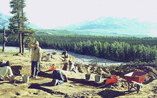
The DIL-161 Site is a prehistoric archeological site in Katmai National Park and Preserve. Located on the banks of the Alagnak River, the site was first identified in 1997 by National Park Service personnel, and its extents were mapped in 2004. The site is that of a village that was occupied between about 300 BCE and 800 CE. More than 40 cabin sites, which are little more than house pits, have been identified.
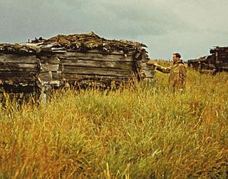
The Old Savonoski Site is the former site of a native village in Lake and Peninsula Borough, Alaska, that was buried by ash in the June 1912 eruption of the Novarupta Volcano. The site is located near the confluence of the Savonoski and Ukak Rivers, and is within the bounds of the Katmai National Park and Preserve. The site was visited by archaeologists in 1953, who identified a number of surviving elements, including fifteen barabaras, or semi-subterranean dwellings.
Brooks Camp is a visitor attraction and archeological site in Katmai National Park and Preserve, noted for its opportunities for visitors to observe Alaskan brown bears catching fish in the falls of the Brooks River during salmon spawning season. The Brooks River connects Lake Brooks and Naknek Lake over about 2 kilometres (1.2 mi). This natural choke point for salmon runs made it an attractive location for prehistoric Alaskans, who occupied the area from 4500 BP. The Aglegmuit people lived along the Brooks River in historical times. The Brooks River Archeological District, which includes Brooks Camp, was designated a National Historic Landmark in 1993.

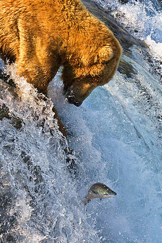
Brooks Falls is a waterfall located within Katmai National Park and Preserve in Alaska. Located on the Brooks River a mile and a half (2.4 km) from Brooks Lake and an equal distance from Naknek Lake, the falls are famous for watching salmon leap over the 6 foot falls to get to their Brooks Lake spawning grounds. Consequently, large populations of brown bears are attracted to feed on the spawning salmon. Brown bears usually congregate at the falls in July through early September, and many well-known photos of bears have been taken there. July witnesses the greatest concentrations of bears of any month at the falls; up to 25 bears have been seen at one time at Brooks Falls in that month. In September, a smaller number of bears can be seen at the falls to feast on the later salmon runs.

Aquadoctan was one of the largest known Native American villages in what is now the U.S. state of New Hampshire. In an area commonly known today as The Weirs, the village lay on the north bank of the Winnipesaukee River at the outlet of Lake Winnipesaukee in the Lakes Region of New Hampshire. The site is now in Weirs Beach, a summer resort and village of the city of Laconia. The Native American village, whose archaeological remains extend for a half mile along the river and a quarter mile along the lake, has been documented through archaeological investigation to have evidence of settlement from 9,000 BCE to the late seventeenth century. Colonial reports document that the site was abandoned substantially in 1696, when most of New Hampshire's remaining native population withdrew to join the Pequawket at present-day Fryeburg, Maine.
The Kaguyak Village Site, designated 49 Afg 4, is a historic and prehistoric archaeological site on the Pacific coast of the Alaska Peninsula in Katmai National Park and Preserve. It is the site of an Alaska Native village which was abandoned after the eruption of Novarupta in 1912. The historic elements of the site include the remains of a Russian Orthodox church and cemetery, as well as a number of frame house remnants and foundations.
Takli Island is an island off the southern coast of the Alaska Peninsula in the Shelikof Strait of southwestern Alaska. It is located at the mouth of Amalik Bay, off the mainland portion of Kodiak Island Borough, in Katmai National Park and Preserve. The area was first archaeologically investigated in the 1960s, when the prehistory of the area was little known, and the island's sites are type sites for a series of archaeological cultures.

The Kukak Village Site is a prehistoric and historic archaeological site, located on the shore of Kukak Bay, on the south coast of the Alaska Peninsula in Katmai National Park and Preserve. The area was documented to be occupied in the early 20th century, and was abandoned after the 1912 volcanic eruption of Novarupta. The Kukak Bay area is also of prehistoric significance, with researchers identifying 89 depressions as likely sites of subterranean houses, and a refuse midden.
The Savonoski River Archeological District encompasses a complex of prehistoric and historic archaeological sites on the Savonoski River near the mouth of the Grosvenor River in Katmai National Park and Preserve, located on the Alaska Peninsula of southwestern Alaska. At least two sites, designated 49-MK-3 and 49-MK-4 by state archaeologists, were identified when the site was listed in 1978. In 2003, the district was enlarge to include a third site, XMK-53. This area is believed to be the site of one of a group of Native Alaskan settlements referred to in Russian records as "Severnovsk". Excavations of a known prehistoric site in 1964 uncovered additional evidence of a post-contact settlement.


