National Register of Historic Places listings in Wrangell, Alaska

Last updated

Location of Wrangell in Alaska Map of Alaska highlighting Wrangell City and Borough.svg
Location of Wrangell in Alaska

This is a list of the National Register of Historic Places listings in Wrangell, Alaska.

Contents

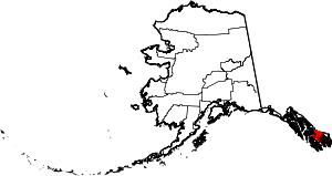
This is intended to be a complete list of the properties and districts on the National Register of Historic Places in Wrangell, Alaska, United States. The locations of National Register properties and districts for which the latitude and longitude coordinates are included below, may be seen in a Google map. [1]

There are 4 properties and districts listed on the National Register in the city and borough. Another property was once listed but has been removed.


    This National Park Service list is complete through NPS recent listings posted February 28, 2025. [2]

Current listings

[3] Name on the Register [4] ImageDate listed [5] Location City or townDescription
1 Chief Shakes Historic Site
Chief Shakes Historic Site Shakes Island.jpg
Chief Shakes Historic Site
October 27, 1970
(#70000918)
Shakes Island, inside Wrangell Harbor
56°27′57″N132°22′50″W / 56.46571°N 132.38062°W / 56.46571; -132.38062 (Chief Shakes Historic Site)
Wrangell
2 Etolin Canoe
Etolin Canoe EtolinCanoeBow.png
Etolin Canoe
June 5, 1989
(#88001061)
Head of Brunett Inlet, Etolin Island, Tongass National Forest
56°10′23″N132°27′25″W / 56.17303°N 132.45701°W / 56.17303; -132.45701 (Etolin Canoe)
Wrangell
3 Judith Ann (Riverboat) July 7, 2004
(#04000658)
Mile 12.25 of Zimovia Highway, about 10 miles (16 km) south of Wrangell
56°19′22″N132°20′48″W / 56.32285°N 132.34674°W / 56.32285; -132.34674 (Judith Ann (Riverboat))
Wrangell
4 Saint Philip's Episcopal Church
Saint Philip's Episcopal Church St. Philip's Church, Wrangell, Alaska.png
Saint Philip's Episcopal Church
May 6, 1987
(#87000654)
446 Church Street
56°28′11″N132°22′43″W / 56.46979°N 132.37853°W / 56.46979; -132.37853 (Saint Philip's Episcopal Church)
Wrangell

Former listing

[3] Name on the RegisterImageDate listedDate removedLocation City or townDescription
1 Wrangell Public School May 16, 1978
(#78003432)
May 10, 1996Corner of 2nd Street and Bevier Street
56°28′25″N132°23′14″W / 56.47366°N 132.38723°W / 56.47366; -132.38723 (Wrangell Public School)
Wrangell Originally the public school, became the town hall in 1931. Demolished in 1996.

See also

References

  1. The latitude and longitude information provided in this table was derived originally from the National Register Information System, which has been found to be fairly accurate for about 99% of listings. Some locations in this table may have been corrected to current GPS standards.
  2. National Park Service, United States Department of the Interior, "National Register of Historic Places: Weekly List Actions", retrieved February 28, 2025.
  3. 1 2 Numbers represent an alphabetical ordering by significant words. Various colorings, defined here, differentiate National Historic Landmarks and historic districts from other NRHP buildings, structures, sites or objects.
  4. "National Register Information System". National Register of Historic Places . National Park Service. April 24, 2008.
  5. The eight-digit number below each date is the number assigned to each location in the National Register Information System database, which can be viewed by clicking the number.