National Register of Historic Places listings in Nome Census Area, Alaska

Last updated
Location of the Nome Census Area in Alaska Map of Alaska highlighting Nome Census Area.svg
Location of the Nome Census Area in Alaska

This is a list of the National Register of Historic Places listings in Nome Census Area, Alaska.

Contents

This is intended to be a complete list of the properties and districts on the National Register of Historic Places in Nome Census Area, Alaska, United States. The locations of National Register properties and districts for which the latitude and longitude coordinates are included below, may be seen in a Google map. [1]

There are 20 properties and districts listed on the National Register in the census area, including 3 National Historic Landmarks. Another property was once listed but has been removed.

This National Park Service list is complete through NPS recent listings posted April 10, 2020. [2]
Map this section's coordinates using: OpenStreetMap  
Download coordinates as: KML  ·  GPX

Current listings

[3] Name on the Register [4] ImageDate listed [5] Location City or townDescription
1 Anvil Creek Gold Discovery Site
Anvil Creek Gold Discovery Site Anvil Creek Gold Discovery Site.jpg
Anvil Creek Gold Discovery Site
October 15, 1966
(#66000159)
About 4.25 miles (6.84 km) north of Nome, along Anvil Creek
64°33′13″N165°25′26″W / 64.55372°N 165.42382°W / 64.55372; -165.42382 (Anvil Creek Gold Discovery Site)
Nome Also a contributing site to Cape Nome Mining District Discovery Sites.
2 Jacob Berger House August 3, 1977
(#77000219)
308 2nd Avenue
64°29′57″N165°24′33″W / 64.49929°N 165.40908°W / 64.49929; -165.40908 (Jacob Berger House)
Nome
3 Bureau of Indian Affairs Unalakleet School
Bureau of Indian Affairs Unalakleet School Old BIA School Unalakleet (10313172756).jpg
Bureau of Indian Affairs Unalakleet School
May 22, 2002
(#02000536)
Along E Street and F Street, west of Main Road
63°52′18″N160°47′16″W / 63.87164°N 160.7879°W / 63.87164; -160.7879 (Bureau of Indian Affairs Unalakleet School)
Unalakleet
4 Cape Nome Mining District Discovery Sites
Cape Nome Mining District Discovery Sites Nome prospectors,1900.jpg
Cape Nome Mining District Discovery Sites
June 2, 1978
(#78000535)
Nome Beach Site, Anvil Creek Gold Discovery Site, Snow Creek Placer Claim No. 1 and Erik Lindblom Placer Claim
64°32′58″N165°24′46″W / 64.54943°N 165.41278°W / 64.54943; -165.41278 (Cape Nome Mining District Discovery Sites)
Nome
5 Cape Nome Roadhouse
Cape Nome Roadhouse Cape Nome Roadhouse.jpg
Cape Nome Roadhouse
December 12, 1976
(#76000361)
Mile 14 of Nome-Council Highway
64°26′33″N164°58′38″W / 64.44261°N 164.97721°W / 64.44261; -164.97721 (Cape Nome Roadhouse)
Nome
6 Council City and Solomon River Railroad
Council City and Solomon River Railroad Rusting locomotives near Nome.jpg
Council City and Solomon River Railroad
March 2, 2001
(#01000109)
Mile 31 of Nome-Council Highway
64°32′46″N164°26′12″W / 64.54612°N 164.43657°W / 64.54612; -164.43657 (Council City and Solomon River Railroad)
Solomon
7 Discovery Saloon
Discovery Saloon Discovery Saloon, Nome (Nome Census Area, Alaska).jpg
Discovery Saloon
April 3, 1980
(#80000759)
Corner of West Lomen Avenue and West D Street
64°29′58″N165°24′53″W / 64.49936°N 165.41477°W / 64.49936; -165.41477 (Discovery Saloon)
Nome
8 Fort St. Michael
Fort St. Michael St. Michael, 1901. - NARA - 297212.jpg
Fort St. Michael
November 10, 1977
(#77000221)
Vicinity of St. Michael
63°28′42″N162°02′23″W / 63.47833°N 162.03968°W / 63.47833; -162.03968 (Fort St. Michael)
St. Michael
9 Gambell Sites
Gambell Sites Ayveghyaget Site.jpg
Gambell Sites
October 15, 1966
(#66000160)
Address restricted [6]
St. Lawrence Island
10 Iyatayet Site
Iyatayet Site Iyatayet Site.jpg
Iyatayet Site
October 15, 1966
(#66000158)
Northwestern shore of Cape Denbigh on Norton Bay [7]
Cape Denbigh Peninsula
11 Erik Lindblom Placer Claim November 21, 1976
(#76000362)
About 6 miles (9.7 km) northwest of Nome
64°35′10″N165°26′08″W / 64.58613°N 165.43565°W / 64.58613; -165.43565 (Erik Lindblom Placer Claim)
Nome Also a contributing site to Cape Nome Mining District Discovery Sites.
12 Norge Storage Site October 9, 1974
(#74000441)
Front Avenue
65°15′43″N166°21′40″W / 65.26181°N 166.361°W / 65.26181; -166.361 (Norge Storage Site)
Teller Warehouse where remains of the Arctic airship Norge were stored after its 1926 overflight of the North Pole.
13 Old St. Joseph's Catholic Church
Old St. Joseph's Catholic Church St. Joseph's Church, Nome, Alaska.jpg
Old St. Joseph's Catholic Church
March 8, 2000
(#00000149)
Across Bering Street, in front of West Seppala Drive
64°30′00″N165°24′28″W / 64.49989°N 165.40768°W / 64.49989; -165.40768 (Old St. Joseph's Catholic Church)
Nome
14 Pilgrim Hot Springs
Pilgrim Hot Springs Former Catholic Mission Church at Pilgrim Hot Springs.jpg
Pilgrim Hot Springs
April 11, 1977
(#77000223)
About 8 miles (13 km) south of Mile 65 of Kougarok Road
65°05′34″N164°55′23″W / 65.09272°N 164.92297°W / 65.09272; -164.92297 (Pilgrim Hot Springs)
Teller
15 St. Michael Redoubt Site
St. Michael Redoubt Site StMichaelRedoubt.jpeg
St. Michael Redoubt Site
November 10, 1977
(#77000222)
Address restricted [6]
St. Michael
16 Snow Creek Placer Claim No. 1 September 28, 1976
(#76000363)
About 6.5 miles (10.5 km) north of Nome
64°35′49″N165°24′26″W / 64.59706°N 165.40731°W / 64.59706; -165.40731 (Snow Creek Placer Claim No. 1)
Nome Also a contributing site to Cape Nome Mining District Discovery Sites.
17 Solomon Roadhouse
Solomon Roadhouse Solomon Roadhouse.jpg
Solomon Roadhouse
September 17, 1980
(#80000760)
Mile 32 of Nome-Council Highway
64°33′31″N164°26′34″W / 64.55874°N 164.44279°W / 64.55874; -164.44279 (Solomon Roadhouse)
Solomon
18 Swanberg Dredge
Swanberg Dredge Swanberg Dredge.jpg
Swanberg Dredge
March 12, 2001
(#01000232)
Mile 1 of Nome-Council Highway
64°29′33″N165°21′58″W / 64.49261°N 165.36611°W / 64.49261; -165.36611 (Swanberg Dredge)
Nome
19 Teller Mission Orphanage October 21, 2001
(#01001117)
Corner of Post Officer Road and Tuksuk Street
65°19′57″N166°29′10″W / 65.33237°N 166.48611°W / 65.33237; -166.48611 (Teller Mission Orphanage)
Brevig Mission Building no more standing since 2015. [lower-alpha 1]
20 Wales Sites
Wales Sites Wales Site.jpg
Wales Sites
October 15, 1966
(#66000161)
Address restricted [6]
Wales

Former listing

[3] Name on the RegisterImageDate listedDate removedLocationCity or townSummary
1 Lt. C. V. Donaldson
Lt. C. V. Donaldson MV DONALDSON, BEACHED AT SOUTHERN TIP OF BELMONT POINT, LOOKING SOUTHWEST - City of Nome, Nome, Nome Census Area, AK HABS AK,14-NOME,2-32.tif
Lt. C. V. Donaldson
April 11, 1977
(#77000220)
January 3, 1990Southern tip of Belmont Point
64°30′05″N165°25′25″W / 64.50128°N 165.42351°W / 64.50128; -165.42351 (Lt. C. V. Donaldson)
Nome Wreck no more present on the beach.
2 Carrie McLain House December 19, 1978
(#78000534)
June 4, 1990Belmont Point
Nome

See also

Notes

  1. Cfr. "Aerial view of Brevig Mission". September 2015. Retrieved June 8, 2017. and modern satellite imagery with maps present in "NRHP nomination for Teller Mission Orphanage". National Park Service. Retrieved 2015-03-24. and "Brevig Mission Local Economic Development Plan" (PDF). January 9, 2014. p. 18. Retrieved June 8, 2017.

Related Research Articles

National Register of Historic Places listings in Aleutians West Census Area, Alaska Wikimedia list article

This is a list of the National Register of Historic Places listings in Aleutians West Census Area, Alaska.

National Register of Historic Places listings in Bethel Census Area, Alaska Wikimedia list article

This is a list of the National Register of Historic Places listings in Bethel Census Area, Alaska.

National Register of Historic Places listings in Dillingham Census Area, Alaska Wikimedia list article

This is a list of the National Register of Historic Places listings in Dillingham Census Area, Alaska.

National Register of Historic Places listings in Hoonah–Angoon Census Area, Alaska Wikimedia list article

This is a list of the National Register of Historic Places listings in Hoonah–Angoon Census Area, Alaska.

National Register of Historic Places listings in Southeast Fairbanks Census Area, Alaska Wikimedia list article

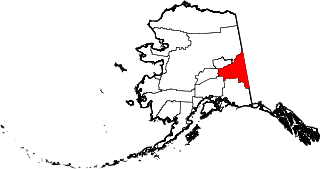
This is a list of the National Register of Historic Places listings in Southeast Fairbanks Census Area, Alaska.

National Register of Historic Places listings in Valdez–Cordova Census Area, Alaska Wikimedia list article

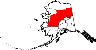
This is a list of the National Register of Historic Places listings in Valdez–Cordova Census Area, Alaska.

National Register of Historic Places listings in Yukon–Koyukuk Census Area, Alaska Wikimedia list article

This is a list of the National Register of Historic Places listings in Yukon–Koyukuk Census Area, Alaska.

National Register of Historic Places listings in Anchorage, Alaska Wikimedia list article

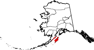
This is a list of the National Register of Historic Places listings in Anchorage, Alaska.

National Register of Historic Places listings in Denali Borough, Alaska Wikimedia list article

This is a list of the National Register of Historic Places listings in Denali Borough, Alaska.

National Register of Historic Places listings in Kenai Peninsula Borough, Alaska Wikimedia list article

This is a list of the National Register of Historic Places listings in Kenai Peninsula Borough, Alaska.

National Register of Historic Places listings in Kodiak Island Borough, Alaska Wikimedia list article

This is a list of the National Register of Historic Places listings in Kodiak Island Borough, Alaska.

National Register of Historic Places listings in Lake and Peninsula Borough, Alaska Wikimedia list article

This is a list of the National Register of Historic Places listings in Lake and Peninsula Borough, Alaska.

National Register of Historic Places listings in Northwest Arctic Borough, Alaska Wikimedia list article

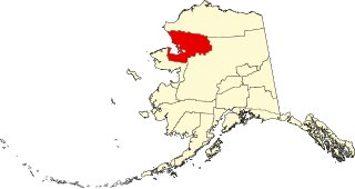
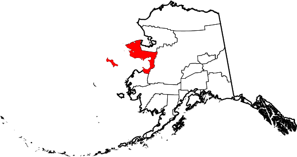
This is a list of the National Register of Historic Places listings in Northwest Arctic Borough, Alaska.

National Register of Historic Places listings in Matanuska-Susitna Borough, Alaska Wikimedia list article

This is a list of the National Register of Historic Places listings in Matanuska-Susitna Borough, Alaska.

National Register of Historic Places listings in North Slope Borough, Alaska Wikimedia list article

This is a list of the National Register of Historic Places listings in North Slope Borough, Alaska.

National Register of Historic Places listings in Pitt County, North Carolina Wikimedia list article

This list includes properties and districts listed on the National Register of Historic Places in Pitt County, North Carolina. Click the "Map of all coordinates" link to the right to view an online map of all properties and districts with latitude and longitude coordinates in the table below.

This is a list of the National Register of Historic Places listings in Denali National Park and Preserve.

This is a list of the National Register of Historic Places listings in Wrangell–St. Elias National Park and Preserve.

This is a list of the National Register of Historic Places listings in Lake Clark National Park and Preserve.

This is a list of the National Register of Historic Places listings in Katmai National Park and Preserve.

References

  1. The latitude and longitude information provided in this table was derived originally from the National Register Information System, which has been found to be fairly accurate for about 99% of listings. Some locations in this table may have been corrected to current GPS standards.
  2. "National Register of Historic Places: Weekly List Actions". National Park Service, United States Department of the Interior. Retrieved on April 10, 2020.
  3. 1 2 Numbers represent an ordering by significant words. Various colorings, defined here, differentiate National Historic Landmarks and historic districts from other NRHP buildings, structures, sites or objects.
  4. "National Register Information System". National Register of Historic Places . National Park Service. April 24, 2008.
  5. The eight-digit number below each date is the number assigned to each location in the National Register Information System database, which can be viewed by clicking the number.
  6. 1 2 3 Federal and state laws and practices restrict general public access to information regarding the specific location of this resource. In some cases, this is to protect archeological sites from vandalism, while in other cases it is restricted at the request of the owner. See: Knoerl, John; Miller, Diane; Shrimpton, Rebecca H. (1990), Guidelines for Restricting Information about Historic and Prehistoric Resources, National Register Bulletin, National Park Service, U.S. Department of the Interior, OCLC   20706997 .
  7. This location is derived from its National Historic Landmark data page Archived 2012-09-12 at the Wayback Machine ; the NRIS lists it as "Address Restricted"