The Thule or proto-Inuit were the ancestors of all modern Inuit. They developed in coastal Alaska by 1000 AD and expanded eastward across northern Canada, reaching Greenland by the 13th century. In the process, they replaced people of the earlier Dorset culture who had previously inhabited the region. The appellation "Thule" originates from the location of Thule in northwest Greenland, facing Canada, where the archaeological remains of the people were first found at Comer's Midden.

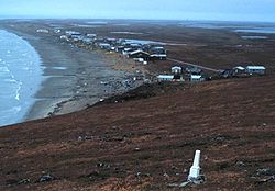
Cape Krusenstern National Monument and the colocated Cape Krusenstern Archeological District is a U.S. National Monument and a National Historic Landmark centered on Cape Krusenstern in northwestern Alaska. The national monument was one of fifteen new National Park Service units designated by the Alaska National Interest Lands Conservation Act (ANILCA) of 1980. It was initially declared a national monument under the authority of the Antiquities Act by President Jimmy Carter on December 1, 1978.
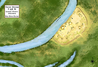
Plum Bayou Mounds Archeological State Park, formerly known as "Toltec Mounds Archeological State Park", also known as Knapp Mounds, Toltec Mounds or Toltec Mounds site, is an archaeological site from the Late Woodland period in Arkansas that protects an 18-mound complex with the tallest surviving prehistoric mounds in Arkansas. The site is on the banks of Mound Lake, an oxbow lake of the Arkansas River. It was occupied by its original inhabitants from the 7th to the 11th century. The site is designated as a National Historic Landmark.

The Amalik Bay Archeological District is a geographic area with a significant number of archaeological sites in Alaska. It is located on the Pacific coast of Katmai National Park and Preserve, in the mainland portion of Kodiak Island Borough, Alaska.

The Birnirk site is an archaeological site near Utqiagvik, Alaska. It includes sixteen prehistoric mounds which have yielded evidence of very early Birnirk and Thule culture. It is the type site of the Birnirk culture, and was designated a National Historic Landmark in 1962 for its archaeological importance in understanding prehistoric Arctic cultures.

The Brooks River Archaeological District encompasses a large complex of archaeological sites along the banks of the Brooks River in Katmai National Park and Preserve in the U.S. state of Alaska. It includes at least twenty separate settlement sites with documented occupation dates from 2500 BCE to recent (post-contact) history. It was declared a National Historic Landmark in 1993. The site is partly occupied by the Brooks Camp, one of the major visitor areas of the park.

The Gallagher Flint Station Archeological Site is an archaeological site and National Historic Landmark in northern Alaska. Discovered in 1970 during the construction of the Trans-Alaska Pipeline, it yielded a radiocarbon date of 10,540 B.P., making it the oldest site of human activity then known in the state at the time of its discovery.

The Iyatayet site is an archaeological site and National Historic Landmark located on the northwest shore of Cape Denbigh on Norton Bay in Nome Census Area, Alaska. It shows evidence of several separate cultures, dating back as far as 6000 B.C. It was excavated starting in 1948 by J. Louis Giddings, the pioneering archaeologist of the area. It is significant as the type site of the Norton culture, representative of human occupation c. 500BCE-500CE, first described by Giddings in 1964. It is also significant for the Denbigh Flint complex, which lay underneath the Norton materials, and provides evidence of some of the earliest human activity in the region. The site was declared a National Historic Landmark in 1961.

The Onion Portage Archeological District encompasses a major archaeological site in Kobuk Valley National Park in northwestern Alaska. The site is a deeply stratified site, at which archaeologists have located nine complexes ranging dating from approximately 6500BC to AD1700. The site has been of critical benefit for the study of Arctic cultures, and is used to determine the cultural chronology of the region.
The Palugvik Site, also known as Palugvik Archeological District, is an archaeological site on Hawkins Island in Prince William Sound, near Cordova, Alaska, within Chugach National Forest. The site, first excavated in 1930, was the first to provide a view of prehistoric human habitation in Prince William Sound, the ancestral home of the Chugach people, and is one of the two primary sites for identifying the sequence of occupation in the area. The site was declared a National Historic Landmark in 1962, and listed on the National Register of Historic Places in 1966.

Yukon Island is an island in outer Kachemak Bay, an inlet of the Cook Inlet of south central Alaska. The island is located about 9 miles (14 km) south of Homer. The island is archaeologically sensitive, with a number of sites documenting the prehistory of the bay. The Yukon Island Main Site, a National Historic Landmark, is a major shell midden site at which the pioneering archaeologist Frederica de Laguna was able to sequence 1500 years of the area's prehistory, and other sites have been found on the island since then. The island is now home to an educational retreat center.

The Walrus Islands are a group of craggy coastal islands in the Bering Sea, close to the northern shores of Bristol Bay, Alaska at the entrance to Togiak Bay. They are located 18 km to the east of Hagemeister Island, and are protected as the Walrus Islands State Game Sanctuary by the state. A part of the island group is also of archaeological importance, with numerous deeply stratified sites covering 6,000 years of human use. For this reason, Crooked Island, Summit Island and Round Island were designated the Walrus Islands Archeological District, a National Historic Landmark District comprising 14 historical sites, in December 2016.

The Gambell Sites are five archeological sites which established a chronology of over 2000 years of human habitation on St. Lawrence Island near Gambell, Alaska.
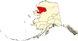
This is a list of the National Register of Historic Places listings in Northwest Arctic Borough, Alaska.

This is a list of the National Register of Historic Places listings in Matanuska-Susitna Borough, Alaska.

This is a list of the National Register of Historic Places listings in North Slope Borough, Alaska.
Takli Island is an island off the southern coast of the Alaska Peninsula in the Shelikof Strait of southwestern Alaska. It is located at the mouth of Amalik Bay, off the mainland portion of Kodiak Island Borough, in Katmai National Park and Preserve. The area was first archaeologically investigated in the 1960s, when the prehistory of the area was little known, and the island's sites are type sites for a series of archaeological cultures.

This is a list of the National Register of Historic Places listings in Copper River Census Area, Alaska.