
Teller is a city in the Nome Census Area, Alaska, United States. At the 2010 census the population was 229, a decrease from 268 in 2000.
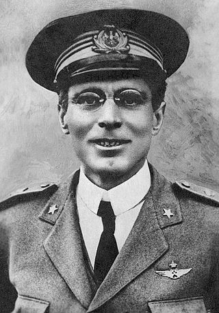
Umberto Nobile was an Italian aviator, aeronautical engineer and Arctic explorer.

The Norge was a semi-rigid Italian-built airship that carried out the first verified trip of any kind to the North Pole, an overflight on 12 May 1926. It was also the first aircraft to fly over the polar ice cap between Europe and America. The expedition was the brainchild of polar explorer and expedition leader Roald Amundsen, the airship's designer and pilot Umberto Nobile and the wealthy American adventurer and explorer Lincoln Ellsworth who, along with the Norwegian Aviation Society, financed the trip, which was known as the Amundsen-Ellsworth 1926 Transpolar Flight.

Sitka National Historical Park is a national historical park in Sitka in the U.S. state of Alaska. It was redesignated as a national historical park from its previous status as national monument on October 18, 1972. The park in its various forms has sought to commemorate the Tlingit and Russian experiences in Alaska.

Alaska Native Brotherhood Hall, or Sitka Camp No. 1, is significant for being the original chapter of the Alaska Native Brotherhood, an Alaska-wide Native organization. It is located on the waterfront in Sitka, Alaska, on Katlian Street.

Cape Nome Mining District Discovery Sites is a National Historic Landmark located in Nome, Alaska. It was named a National Historic Landmark in 1978. It is significant for its role in the history of gold mining in Alaska, in particular the Nome Gold Rush that began in 1899.
The Death Canyon Barn is a combination barn and ranger patrol cabin in Grand Teton National Park. The barn was built in Death Canyon on the Death Canyon Trail at its junction with the Alaska Basin Trail by the Civilian Conservation Corps in 1935 in the National Park Service rustic style. Located with a clear view of Prospector Mountain, it shares a common style and purpose with the Cascade Canyon Barn to the north in the park, with minor differences attributable to available materials and the preferences of the work crews building the barns.
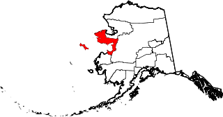
This is a list of the National Register of Historic Places listings in Nome Census Area, Alaska.
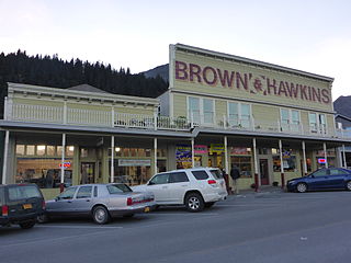
Brown & Hawkins is a general store in Seward, Alaska. It was founded in 1904 to serve the town and those constructing of the Alaska Central Railroad, and has been the oldest continuously operating business in Seward. It was listed on the National Register of Historic Places in 1988. It was announced in 2013 that the owners were retiring without finding anyone to buy their business.
The Nome Gold Rush was a gold rush in Nome, Alaska, approximately 1899–1909. It is separated from other gold rushes by the ease with which gold could be obtained. Much of the gold was lying in the beach sand of the landing place and could be recovered without any need for a claim. Nome was a sea port without a harbor, and the biggest town in Alaska.

Strang School District No. 36, or the Strang Public School, is a historic school located in Fillmore County, Nebraska, in the village of Strang. The school is one of the two sites listed on the National Register of Historic Places in the village of Strang. The school building is a small, two-story, brick public schoolhouse, which was built to replace the schoolhouse that was previously located on that site. The schoolhouse was built between 1929 and 1930, and replaced the previous schoolhouse, which burned down in 1928. The schoolhouse still retains all original building materials. The school served high school students from 1930 to 1951, and still functions as a school today, serving grades K–8. The NRHP listing also includes a flagpole located outside the schoolhouse, and five pieces of playground equipment.
The Nome–Council Highway is a highway that runs for 71.970 miles (115.824 km) between the communities of Council and Nome in the Nome Census Area of the Unorganized Borough in the U.S. state of Alaska. The road travels east from Nome, following the shore of the Bering Sea until it reaches the ghost town of Solomon. From there, the route travels northeast through the interior of the Seward Peninsula before it terminates on the south bank of the Niukluk River, south of Council. One of three highways traveling from Nome to surrounding communities, the highway is disconnected from the rest of the Alaska Highway System. The route is unpaved for its entire length and becomes impassable for automobiles in the winter outside of a short portion immediately outside of Nome. The portion of the road between Nome and Solomon is part of the Iditarod Trail and the highway passes several historic sites associated with the trail and the area's gold mining history.

The Jacob Berger House, also known locally as the Sally Carrighar House, is a historic Gold Rush mansion at 308 2nd Avenue in Nome, Alaska. It is a two-story late Victorian house, built in 1903-04 by Jacob Berger, a miner who had at least three major finds during the Nome Gold Rush. It was built out of high quality material brought to Nome from west coast ports, and was based on a pattern from an architectural pattern book, with special adaptations for Nome's harsh climate. The main block of the house has a hip roof above a shortened second story, and has a square projecting section in the front which has a full-height second story and is topped by a pyramidal roof. The house is also unusual for the period for the size and number of windows it has.

The Bureau of Indian Affairs Unalakleet School, also known as the Unalakleet Day School and BIA School and Quarters, is a historic school complex in Unalakleet, Alaska, a small community about 150 miles (240 km) southeast of Nome at the mouth of the Unalakleet River. The complex includes the main school building, a light plant, a warehouse and the former Teacher's Quarters, Clinic's Quarters and Duplex Quarters across 2nd Street. The school building is a Georgian Revival structure, 2+1⁄2 stories in height, built in 1933 with balloon framing, a gable roof with octagonal cupola, and a concrete foundation. Shed-roof dormers were added in 1937, and an addition in 1954. The building housed classrooms and other facilities on the first two floors, and two small apartments in the attic space. The school was built by the United States Bureau of Indian Affairs as part of a major program to assimilate Alaska's Native population, and was operated from these premises until 1978, when the state built a new school.

The Discovery Saloon is a historic building at 1st and D Streets in Nome, Alaska. Now a private residence, this two-story wood-frame building with false front was built in 1901 by Max Gordon, who operated a high-end public establishment on the premises. It is the oldest commercial building in Nome, and one of the few to survive from Nome's gold rush days. It was converted to one of Nome's finest private residences in the 1940s.
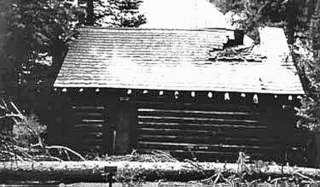
Pilgrim Hot Springs is a ghost town in the interior of the Seward Peninsula of northwestern Arctic Alaska. Also known as Kruzgamepa, it is located on the southeast bank of the Kruzgamepa River, about 8 miles (13 km) south of milepost 65 of the Kougarok Road. The location gained prominence in the early 20th century because of its thermal hot springs, which made agricultural homesteading possible, and which were adapted to provide a respite for the gold miners of Nome. Early buildings, built 1900–03, were of log construction, and included a log cabin, barn and chicken house. A roadhouse and saloon were built after 1903, but were destroyed by fire in 1908, after the mining boom had ended.
The Oddfellows House, also known as Oddfellows Hall, is a former fraternal clubhouse of Oddfellows at 825 1st Avenue in Fairbanks, Alaska. It is a wood-frame building with two sections, the front one a narrow two-story structure, the rear one a wider single-story structure. Each section has its own gable roof, although they do briefly align. The building was built in 1907 by Madame Renio, a fortune teller, and initially housed a clinic and residential space in the front and a bathhouse in the rear. The bathhouse business failed after its pipes froze in the winter of 1909–10, and the building was purchased by the local chapter of the International Order of Odd Fellows (IOOF). This fraternal organization converted the front space into a kitchen and bathroom, and the rear was converted into a large meeting hall. Under the IOOF's ownership the hall was used by a wide variety of civic and religious organizations, including its sister organization, the Golden North Rebekahs. The IOOF chapter was inactive between the late 1930s and 1945, but the Rebekahs continued to maintain the building, eventually taking ownership in 1967. The Rebekahs disbanded in 2007, and the space was briefly used as a museum; it now houses a retail establishment.

The Solomon Roadhouse, also known as the Curran's Roadhouse, is a historic travel accommodation in northwestern Arctic Alaska. It is a two-story frame building located a short way north of the small community of Solomon, which is at the mouth of the Solomon River about 30 miles (48 km) east of Nome on the Nome-Council Highway. The roadhouse was built in 1904, during the days of the Nome Gold Rush, which brought many miners to the Solomon River as well, resulting in the establishment of the communities of Solomon and Dickson, and the construction of a railroad. After the gold rush declined and the communities were devastated by storms and floods, the roadhouse and other buildings were relocated about a mile north of the coast in the 1930s. The roadhouse operated until the 1970s.
The Teller Mission Orphanage was a historic orphanage and mission house located at the corner of Post Officer Road and Tuksuk Street in Brevig Mission, Alaska. This small community was established in 1891 as a station for the importation of reindeer from Siberia to supplement the diet of the local Alaska Native population. The reindeer station was taken over in 1900 by the Norwegian Evangelical Lutheran church, which also undertook to operate a school and orphanage at the site. The 1+1⁄2-story wood-frame building was built in 1917, replacing the original orphanage built in 1907 by Rev. Toleef Larson Brevig, for whom the community is named. It was about 28 by 54 feet, with a gable roof, weatherboard siding, and a metal roof. At the time of its listing on the National Register of Historic Places in 2001, it had been standing vacant for about 20 years. The building is no longer standing as of September 2015.

The Wireless Station is a historic US government telecommunications facility at East Manor and Boyd Streets in Anchorage, Alaska. The property includes three buildings that were used to maintain radio communications in the Anchorage area, with ships at sea, and as a communications link to Seattle, Washington as part of military WAMCATS telecommunications system. In addition, the station was used for communications during the construction of the Alaska Railroad, and, during the 1925 serum run to Nome, it was used to inform the residents of Nome that the diphtheria antitoxin was on its way.

