Chisana is a census-designated place (CDP) in the Copper River Census Area in the U.S. state of Alaska. As of the 2010 Census, the population of the CDP was 0. The English name Chisana derives from the Ahtna Athabascan name Tsetsaan' Na, meaning literally 'copper river'. The Chisana River joins the Nabesna River just north of Northway Junction, Alaska, to form the Tanana River, a major tributary of the Yukon River. The Chisana Airport consists of a turf and gravel runway which is largely serviced by flights from Tok, Alaska.
Fort Durham, also known as Fort Taku, Taku, Taco, and Tacouw, is an archaeological site near Taku Harbor, Alaska, within the limits of Juneau City and Borough and Tongass National Forest. It was one of three Hudson's Bay Company (HBC) posts set up in Russian America. The Fort Durham Site was declared a U.S. National Historic Landmark in 1978.
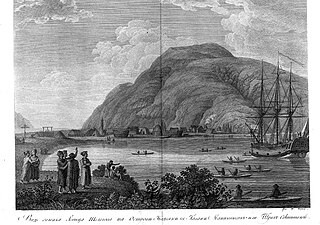
New Russia was a trading-post for furs and a penal colony established by Russians in 1796 in present-day Yakutat Borough, Alaska. It was presumably named after the Joseph Billings ship Slava Rossii, or "Glory of Russia".

Yukon Island is an island in outer Kachemak Bay, an inlet of the Cook Inlet of south central Alaska. The island is located about 9 miles (14 km) south of Homer. The island is archaeologically sensitive, with a number of sites documenting the prehistory of the bay. The Yukon Island Main Site, a National Historic Landmark, is a major shell midden site at which the pioneering archaeologist Frederica de Laguna was able to sequence 1500 years of the area's prehistory, and other sites have been found on the island since then. The island is now home to an educational retreat center.

This is a list of the National Register of Historic Places listings in Aleutians West Census Area, Alaska.

This is a list of the National Register of Historic Places listings in Anchorage, Alaska.

This is a list of the National Register of Historic Places listings in Kenai Peninsula Borough, Alaska.

The Tangle Lakes are a 16-mile (26 km) long chain of lakes connected by streams in interior Alaska. They form the headwaters for the Delta River.

The Redoubt St. Archangel Michael Site, also known as the Old Sitka Site and now in Old Sitka State Historical Park, is a National Historic Landmark near Sitka, Alaska. Now of archaeological interest, the site, about 7 miles (11 km) north of Sitka at the end of Halibut Point Road, was the site of the early Russian-American Company settlement known as Redoubt St. Archangel Michael. It was the first non-Native settlement on Baranof Island. It was declared a National Historic Landmark in 1962, and was made a state park in 1966.
This is a list of the National Register of Historic Places listings in Wrangell–St. Elias National Park and Preserve.
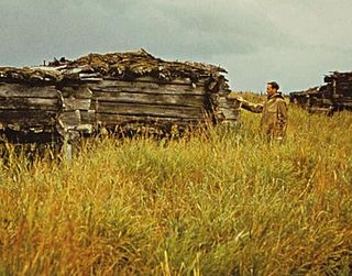
The Old Savonoski Site is the former site of a native village in Lake and Peninsula Borough, Alaska, that was buried by ash in the June 1912 eruption of the Novarupta Volcano. The site is located near the confluence of the Savonoski and Ukak Rivers, and is within the bounds of the Katmai National Park and Preserve. The site was visited by archaeologists in 1953, who identified a number of surviving elements, including fifteen barabaras, or semi-subterranean dwellings.
The Kolmakov Redoubt Site is a historic archaeological site on the Kuskokwim River in western Alaska. The site is located downriver from the hamlet of Sleetmute, about 21 miles east of Aniak. The site was the location of a major trading post, which was one of the only ones established deep in the Alaskan interior by the Russian-American Company. The first site established by the Russians, in 1832, was little more than a log cabin near the confluence of the Kuskokwim with the Aniak River, and was known as Kolmakov's Townlet, after the trader Fedor Kolmakov. The success of this location prompted the construction in 1833 of an "odinochka" at the present location, near the confluence of the Kuskokwim and Kolmakof Rivers. At this site the Russians collected more than 1,400 beaver pelts in 1834, when their entire Alaska trade amounted to about 5,000. This facility was then upgraded to a "redoubt". The site was used until 1867, when American traders took over the fur trade following the Alaska Purchase.
The Russian Kiln Site is a historic archaeological site on Long Island, part of the Kodiak Archipelago of southern Alaska. It is one of the oldest industrial sites in Alaska, established by the Russian American Company for the production of bricks, an otherwise rare commodity in 19th-century Russian America. The kilns on the site were reported to produce between 3000 and 6000 bricks annually. Brick debris is scattered along the shore of Long Island in the area, which subsided after the 1964 Alaska earthquake and is subject to erosion. It is one of several sites in the vicinity of Kodiak Island where the Russians produced bricks.
The Middle Bay Brick Kiln is a historical archaeological site on Kodiak Island, Alaska. Located on an eroding bluff face on Middle Bay, the site contains the remains of a brickmaking facility established by the Russian American Company, probably in the early 19th century. The remains include a 4-by-4-metre Roman-style kiln, with a series of arches that supported the kiln floor and provided a space for the fire. At the time of the site's first major excavation in 1979, elements of at least one arch were in danger of being undermined by the eroding bluff face, and were removed for potential reconstruction by the Kodiak Historical Society. Other notable finds at the site include hand cut nails and a brick with Russian writing on it.

The Kukak Village Site is a prehistoric and historic archaeological site, located on the shore of Kukak Bay, on the south coast of the Alaska Peninsula in Katmai National Park and Preserve. The area was documented to be occupied in the early 20th century, and was abandoned after the 1912 volcanic eruption of Novarupta. The Kukak Bay area is also of prehistoric significance, with researchers identifying 89 depressions as likely sites of subterranean houses, and a refuse midden.
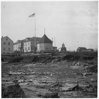
Fort St. Michael was an installation of the United States Army at St. Michael, Alaska, on St. Michael Island in Norton Bay on the central west coast of Alaska. The fort was in active service between 1897 and 1925, and was originally established to maintain order during the Klondike Gold Rush for which St. Michael was a major transshipment point for people and goods moving up the Yukon River, whose mouth is nearby but is inaccessible to ocean-going ships. The installation later became the endpoint of the WAMCATS cable, a military communications cable extending across Alaska. Its importance declined substantially after the Alaska Railroad was completed in 1923, providing year-round service to the interior which was superior to the seasonal transport service of the river. The post was closed in 1925, and the military burials of its graveyard relocated to Sitka National Cemetery in 1929. When surveyed in 1976, only three buildings remained of the once extensive installation.
Magnetic Island is a small island on the north side of Tuxedni Bay, an inlet on the lower west side of Cook Inlet in south-central Alaska. The island is surrounded by mudflats that are under water during high tides. The island got its name from the presence of magnetism identified during a geological survey in 1951. Its shape and geology are heavily influenced by Mount Redoubt and Mount Iliamna, two active volcanoes located less than 20 miles (32 km) away.
The Savonoski River Archeological District encompasses a complex of prehistoric and historic archaeological sites on the Savonoski River near the mouth of the Grosvenor River in Katmai National Park and Preserve, located on the Alaska Peninsula of southwestern Alaska. At least two sites, designated 49-MK-3 and 49-MK-4 by state archaeologists, were identified when the site was listed in 1978. In 2003, the district was enlarge to include a third site, XMK-53. This area is believed to be the site of one of a group of Native Alaskan settlements referred to in Russian records as "Severnovsk". Excavations of a known prehistoric site in 1964 uncovered additional evidence of a post-contact settlement.

This is a list of the National Register of Historic Places listings in Copper River Census Area, Alaska.