Freshwater Redoubt

Last updated

Freshwater Redoubt
Freshwater, Isle of Wight, England
Fort Redoubt Feb 2018 Drone image.jpg
Fort Redoubt on the cliff of Freshwater Bay.
Isle of Wight UK location map.svg
Red pog.svg
Freshwater Redoubt
Coordinates 50°40′10″N1°30′45″W / 50.669497°N 1.512466°W / 50.669497; -1.512466
Site information
OwnerPrivate residence
Open to
the public
No
Site history
Built1855-1856
In use1856-1928
MaterialsBrick

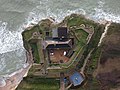
Freshwater Redoubt, also known as Fort Redoubt (map reference SZ345856 ), is an old Palmerston fort built in Freshwater Bay on the western end of the Isle of Wight. Construction work for the fort began in 1855 and was completed in 1856. [1] It was finally sold in 1928 and has now been converted into a private residence.

Contents

Army use

Freshwater Redoubt is a Palmerston fort, completed in 1856 to defend Freshwater Bay, which was a possible landing beach for enemy troops. The deep, dry ditch protects the landward approaches.

The Caponier building in the ditch served as barrack accommodation for 24 men. With its iron window-shutters and rifle slots the Caponier also provided a means of ditch defence. The original bridge had a section, which could be withdrawn, near the entrance gate, for defence purposes. The main building, visible through the gate, was originally a single storey, flat-roofed barrack comprising 3 Officers’ Rooms, an Officers’ Kitchen, Staff Sergeant's Quarters, and 2 rooms for 5 and 11 men.

The fort was designed with 2 batteries for a total of 7 guns. The Upper Battery, facing the sea, had four gun emplacements and a separate Lower Battery with three gun emplacements covered Freshwater Bay. Early muzzle-loading guns, using gunpowder and firing cannonballs, were replaced over the years by rifled, breech-loading guns firing shells as military technology advanced.

Location

The fort is on the Western headland of Freshwater Bay at the foot of Tennyson Down. It enjoys outstanding views of Freshwater Bay to the East and the English Channel to the South and West, with the Solent visible to the North across Freshwater and Yarmouth. The view from the top of the drive is of the Isle of Wight coast running along Compton Bay, with Brighstone Down beyond and continues past Atherfield Point, Chale and Blackgang, towards St. Catherine's Point, with St. Boniface Down in the distance. The small tower visible on the rocks off Hanover Point is an artillery range marker built by the Army. The guns would always fire to seaward of this point

Recent history

The fort is known locally as Fort Redoubt. It was sold by the Army in 1928 and is privately owned. The main building was converted into a two-storey private residence in 1936, and further extended in 1976 but not finished. During the 1980s and 1990s it operated as a tea room. The current owners have completed their own accommodation in the main building and carried out landscaping improvements in the grounds to recover the original setting of the property. The bridge over the moat was replaced in 2011 and, like the original bridge, affords a view of the Caponier along the moat.

The restoration of the Caponier was completed in 2020, and is now 2 holiday lets [2]

Moonfleet cottage in the grounds was originally married quarters accommodation for the master gunner and is now a holiday cottage called Moonfleet [3] Since 1994, it has been a Grade II Listed Building. [4]

In 2005, Peter White wrote Moonfleet the opera, based on the story of Moonfleet by J. Meade Falkner, while staying at Fort Redoubt. [5]

Caponier Restoration (2014-2020)

The Caponier building in the ditch had originally served as barrack accommodation for 24 men. By 2000 the roof and floors had been removed at some time in the past (possible for sale of the timber) and all that was left was the brick walls. When the ivy that had grown rampantly over the walls was removed, the render to the external brickwork was found to be in good condition, along with the structural brick work.

Derelict Caponier 2008 Caponier 2008.png
Derelict Caponier 2008

The Caponier is accessed from the courtyard via a brick tunnel and down 19 steps before arriving at the upper floor of the 2 floor Caponier building - posing practical and logistical challenges for getting materials and furniture in and out. In 2014 renovation of the Caponier building began by stabilising the brick work, and installing a new insulated flat roof and a new first floor. Works continued on and off until 2017 when the period timber sash windows and shutters were installed - making the building weather proof for the first time in over 40 years. In 2018 works began again to convert the weather proof shell into 2 three bedroom holiday lets. During the last phase of the works, a scaffold bridge was built from the North Side of the bridge, across to the North West upper floor window (pictured in gallery). This temporary structure was removed when the works concluded in 2020.

Every effort has been made to retain the authentic history of the Caponier building despite modern fixtures and fittings. The original metal hooks used to hang soldiers hammocks from have been retained throughout; The gun slits (Embrasure) have been retained and glazed keeping the original lines of sight; the original 2 foot thick brick walls have been exposed emphasising the original military purpose of the building.

The Caponier is now 2 comfortably appointed holiday lets arranged over 2 floors (more images available at links)

Renovated Caponier 2020 Caponier 2020 from West looking East.jpg
Renovated Caponier 2020

Further Images

Related Research Articles

<span class="mw-page-title-main">Shoreham Redoubt</span>

<span class="mw-page-title-main">Dover Western Heights</span>

The Western Heights of Dover are one of the most impressive fortifications in Britain. They comprise a series of forts, strong points and ditches, designed to protect the country from invasion. They were created in the 18th and 19th centuries to augment the existing defences and protect the key port of Dover from both seaward and landward attack; by the start of the 20th century Dover Western Heights was collectively reputed to be the 'strongest and most elaborate' fortification in the country. The Army finally withdrew from the Heights in 1956–61; they are now a local nature reserve.

<span class="mw-page-title-main">Dymchurch Redoubt</span>

Dymchurch Grand Redoubt is a fortification at Palmarsh on the coast of Kent in England, built during the Napoleonic War as part of a large defensive scheme to protect the country from an expected French invasion.

Grain Fort is a former artillery fort located just east of the village of Grain, Kent. It was constructed in the 1860s to defend the confluence of the Rivers Medway and Thames during a period of tension with France. The fort's location enabled its guns to support the nearby Grain Tower and Garrison Point Fort at Sheerness on the other side of the Medway. It was repeatedly altered and its guns upgraded at various points in its history, before being decommissioned in 1956 when the UK abolished its coastal defence programme. It was subsequently demolished. The remnants of the fort are still visible and have been incorporated into a coastal park.

<span class="mw-page-title-main">Harwich Redoubt</span> Fort built in 1808-10 to defend Harwich from revolutionary France

<span class="mw-page-title-main">The Needles Batteries</span> Historic military defence sites on Isle of Wight, England

The Needles Batteries are two military batteries built above the Needles stacks to guard the West end of the Solent. The field of fire was from approximately West South West clockwise to Northeast and they were designed to defend against enemy ships.

<span class="mw-page-title-main">Fort Gilkicker</span>

Fort Gilkicker is a historic Palmerston fort built at the eastern end of Stokes Bay, Gosport, Hampshire England to dominate the key anchorage of Spithead. It was erected between 1863 and 1871 as a semi-circular arc with 22 casemates, to be armed with five twelve-inch guns, seventeen ten-inch guns and five nine-inch guns. The actual installed armament rather differed from this. In 1902 the RML guns were replaced by two 9.2-inch and two six-inch BL guns, and before the First World War the walls were further strengthened with substantial earthwork embankments. The fort was disarmed in 1956 and used for storage until 1999, and is currently in a state of disrepair.

<span class="mw-page-title-main">Fort Southwick</span>

Fort Southwick is one of the forts found on Portsdown Hill, which overlooks the naval base of Portsmouth in the county of Hampshire, England.

<span class="mw-page-title-main">Fort Fareham</span> Palmerston Fort in Fareham

Fort Fareham is one of the Palmerston Forts, in Fareham, England. After the Gosport Advanced Line of Fort Brockhurst, Fort Elson, Fort Rowner, Fort Grange and Fort Gomer had been approved by the Royal Commission on the Defence of the United Kingdom a decision was made to build an outer line of three more forts two miles in advance of the Gosport Advanced Line. Of these three projected forts only Fort Fareham was built due to the need to cut costs. It acted as a hinge between the forts on Portsdown Hill and those of the Gosport Advanced Line, filling the gap at Fareham. It has been a Grade II Listed Building since 1976.

<span class="mw-page-title-main">Caponier</span> Type of fortification structure

A caponier is a type of defensive structure in a fortification. Fire from this point could cover the ditch beyond the curtain wall to deter any attempt to storm the wall. The word originates from the French caponnière, meaning "chicken coop".

<span class="mw-page-title-main">Fort Nelson, Hampshire</span> Palmerston fort in Boarhunt

Fort Nelson, in the civil parish of Boarhunt in the English county of Hampshire, is one of five defensive forts built on the summit of Portsdown Hill in the 1860s, overlooking the important naval base of Portsmouth. It is now part of the Royal Armouries, housing their collection of artillery, and a Grade I Listed Building.

<span class="mw-page-title-main">Warden Point Battery</span>

Warden Point Battery is a battery on the Isle of Wight begun in 1862, that was originally armed with 7-inch and 9-inch rifled muzzle loaders on barbette mountings.

<span class="mw-page-title-main">Yaverland Battery</span>

Yaverland Battery is a battery on the Isle of Wight, United Kingdom. It was constructed between 1861 and 1864.

<span class="mw-page-title-main">Sandown Barrack Battery</span> Battery on the Isle of Wight

Sandown Barrack Battery is a battery located in Sandown Bay close to Sandown on the Isle of Wight in England. It is one of the many Palmerston Forts built on the island to protect it in response to a perceived French invasion.

<span class="mw-page-title-main">Cliff End Battery</span>

Cliff End Battery is a battery on the west coast of the Isle of Wight overlooking Fort Albert. It is one of the many Palmerston Forts built on the island to protect it in response to a perceived French invasion. Construction of the battery began in 1862 and was completed by 1868 at a cost of £32,714.

<span class="mw-page-title-main">Bembridge Fort</span> 19th-century fort near Bembridge, Isle of Wight, England

Bembridge Fort is a fort built on the highest point of Bembridge Down close to the village of Bembridge on the Isle of Wight, England. It is one of the many Palmerston Forts built around Portsmouth during the period of the Second French Empire, as a safeguard against a perceived threat of French invasion by Napoleon III.

<span class="mw-page-title-main">Culver Battery</span> Artillery battery in England

Culver Battery is a former coastal artillery battery on Culver Down, on the eastern side of the Isle of Wight, England. The fortification is one of several Palmerston Forts built on the island following concerns about the size and strength of the French Navy in the late 19th century. It was operational during the First and Second World Wars. The battery was closed in 1956.

Many forts and fortifications have been built to protect the Isle of Wight from foreign invasion. Throughout history the island has been a site of key military importance. Controlling both entrances to the Solent and the home of the Royal Navy, Portsmouth. This is a list of most of the fortifications on the island.

<span class="mw-page-title-main">Stokes Bay Lines</span>

The Stokes Bay Lines were part of the great Victorian fortification of Portsmouth Harbour under Lord Palmerston. In 1857 Major Jervois had proposed a complex system of moats (ditches), ramparts and batteries to close off the gap between the new fort at Fort Gomer, and the earlier fort at Fort Gilkicker, and Fort Monckton. This defensive moat was to become the ‘Stokes Bay Lines’.

<span class="mw-page-title-main">Twydall Profile</span>

The Twydall Profile was a style of fortification used in British and Imperial polygonal forts at the end of the 19th century. The sloping earthworks employed in the Twydall Profile were intended to be quick and inexpensive to construct and to be effective in the face of the more powerful artillery and high explosive ammunition being introduced at that time. The name comes from the village of Twydall in Kent, where the first forts of this type were built.

References

  1. "Freshwater Bay Local History". Freshwater Bay Resident's Association. Retrieved 17 July 2009.
  2. Fort Redoubt - Upper Caponier, Caponier Holiday accommodation
  3. Moonfleet cottage Holiday Let, Moonfleet cottage Holiday Let.
  4. Historic England. "Freshwater Redoubt (1292676)". National Heritage List for England . Retrieved 4 April 2015.
  5. Peter White, LinkedIn - Peter White, Composer and conductor.

Publications