
Cape Hatteras Light is a lighthouse located on Hatteras Island in the Outer Banks in the town of Buxton, North Carolina and is part of the Cape Hatteras National Seashore. The lighthouse's semi-unique pattern makes it easy to recognize and famous. It is often ranked high on lists of most beautiful, and famous lighthouses in the US.
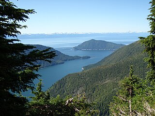
Kuiu Island is an island in the Alexander Archipelago in southeastern Alaska. It lies between Kupreanof Island, to its east, and Baranof Island, to its west. The island is 105 km (65 mi) long, and 10 to 23 km wide. It is nearly cut in two by Affleck Canal. It has 1,936.16 km2 (747.56 sq mi) of land area, making it the 15th largest island in the United States. The entire island is part of Tongass National Forest.

The current Bodie Island Lighthouse is the third that has stood in this vicinity of Bodie Island on the Outer Banks in North Carolina and was built in 1872. It stands 156 feet (48 m) tall and is located on the Roanoke Sound side of a portion of a peninsula that is the first part of the Cape Hatteras National Seashore. The lighthouse is just south of Nags Head, a few miles before Oregon Inlet. It was renovated from August 2009 to March 2013, and was made climbable by the public. There are 214 steps that spiral to the top. The 170-foot structure is one of only a dozen remaining tall, brick tower lighthouses in the United States — and one of the few with an original first-order Fresnel lens to cast its light.

The Point Wilson Light is an active aid to navigation located in Fort Worden State Park near Port Townsend, Jefferson County, Washington. It is one of the most important navigational aids in the state, overlooking the entrance to Admiralty Inlet, the waterway connecting the Strait of Juan de Fuca and Puget Sound. The lighthouse was listed on the Washington State Heritage Register and the National Register of Historic Places in 1971.

Kenosha Light is a lighthouse and keeper's house on Simmons Island north of the channel into Kenosha's harbor in Kenosha County, Wisconsin, USA.

Goat Island Light is a lighthouse located off Cape Porpoise near Kennebunkport in southern Maine. Goat Island Light was established in 1835 to guard the entrance to Cape Porpoise Harbor. The original station was upgraded in 1859 to the current brick tower with a fifth order Fresnel lens. Keeper's quarters were added to the island in 1860. The light station was automated by the United States Coast Guard in 1990 and is currently active. The keepers dwellings and tower are leased to the Kennebunkport Conservation Trust. Goat Island Light can be seen from shore in Cape Porpoise Harbor just off State Route 9 north of Kennebunkport or is viewable by boat. The island is currently closed to the public except by special arrangement.

Patos Island Lighthouse is an active aid to navigation overlooking the Strait of Georgia at Alden Point on the western tip of Patos Island in the San Juan Islands, San Juan County, Washington, in the United States. The station is the northernmost in the San Juan Islands and marks the division point between the eastern and western passages into the Strait of Juan de Fuca.

The Tree Point Light is a lighthouse located adjacent to Revillagigedo Channel in Southeast Alaska, United States. It is located near the southernmost point of mainland Alaska.

The Cape St. Elias Light is a lighthouse on Kayak Island in Alaska.

The Guard Island Light is a lighthouse on a small island near the entrance to the Tongass Narrows, in Clarence Strait in southeastern Alaska. The western entrance to the Behm Canal also lies nearby.
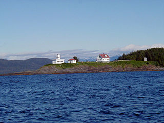
Point Retreat Light is a lighthouse located on the Mansfield Peninsula at the northern tip of Admiralty Island in southeastern Alaska, United States. It provides aid in navigation through the Lynn Canal.
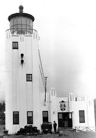
The Cape Hinchinbrook Light is a lighthouse located near the southern end of Hinchinbrook Island adjacent to Prince William Sound, in Alaska, United States.

The Eldred Rock Light is an historic octagonal lighthouse adjacent to Lynn Canal in Alaska. It is the last of the ten lighthouses constructed in Alaska between 1902 and 1906. It was also the last of 12 manned lighthouses that were started in Alaska. It is listed on the National Register of Historic Places as Eldred Rock Lighthouse.
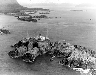
The Cape Spencer Light is a lighthouse in Alaska, United States, next to the entrance to Cross Sound and Icy Strait. The light is still an active aid to navigation. It is located on an islet in the southernmost end of Glacier Bay National Park and Preserve.

The Five Finger Islands Light is a lighthouse located on a small island that lies between Stephens Passage and Frederick Sound in southeastern Alaska. It and Sentinel Island Light Station were the first U.S. government lighthouses opened in Alaska, first lit on March 21, 1902.
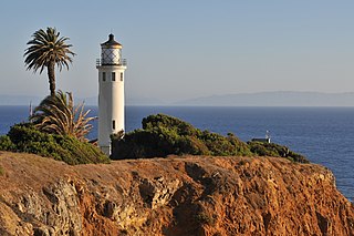
Point Vicente Lighthouse is a lighthouse in Rancho Palos Verdes, California, United States, north of Los Angeles Harbor. It is 67 feet (20 m) tall and stands on a cliff with a height of 130 feet (40 m). It is between Point Loma Lighthouse to the south and Point Conception Lighthouse to the north. The lighthouse was added to the National Register of Historic Places in 1980. The lighthouse is owned by the United States federal government and is managed by the United States Coast Guard. It is not usually open to the public, but the Coast Guard Auxiliary run tours once per month and it is used annually for the city's "Whale of a Day" festival.

The Highland Light is an active lighthouse on the Cape Cod National Seashore in North Truro, Massachusetts. The current tower was erected in 1857, replacing two earlier towers that had been built in 1797 and 1831. It is the oldest and tallest lighthouse on Cape Cod.

The Marquette Harbor Light is located on Lake Superior in Marquette, Michigan, a part of the Upper Peninsula. It is an active aid to navigation.
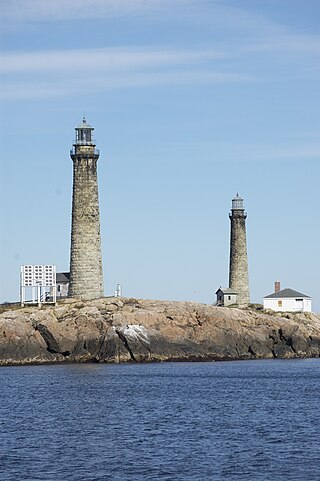
The Cape Ann Light Station on Thacher Island, off Cape Ann in Rockport, Massachusetts, is nationally significant as the last light station to be established under colonial rule and the first station in the United States to mark a navigational hazard rather than a harbor entrance. The current pair of lighthouses were built in 1861. They were both equipped with first order Fresnel lenses, which stood approximately 10 feet (3.0 m) high and weighed several tons (tonnes).
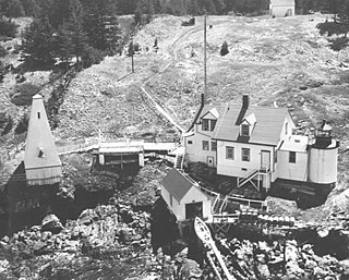
Browns Head Light is a lighthouse in Vinalhaven, Maine. Established in 1832, it is an active aid to navigation, marking the southern side of the western entrance to the Fox Island Thoroughfare, a busy strait separating Vinalhaven Island from North Haven. The present lighthouse was built in 1857; and was listed on the National Register of Historic Places as "Browns Head Light Station" on January 27, 1983.


