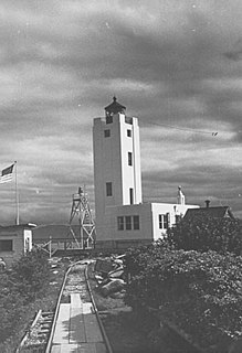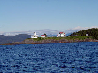
The Mary Island Light Station is a lighthouse located on the northeastern part of Mary Island in southeastern Alaska, United States.

The Tree Point Light is a lighthouse located adjacent to Revillagigedo Channel in Southeast Alaska, United States. It is located near the southernmost point of mainland Alaska.

The Cape St. Elias Light is a lighthouse on Kayak Island in Alaska.

The Guard Island Light is a lighthouse on a small island near the entrance to the Tongass Narrows, in Clarence Strait in southeastern Alaska. The western entrance to the Behm Canal also lies nearby.

Point Retreat Light is a lighthouse located on the Mansfield Peninsula at the northern tip of Admiralty Island in southeastern Alaska, United States. It provides aid in navigation through the Lynn Canal.

The Cape Hinchinbrook Light is a lighthouse located near the southern end of Hinchinbrook Island adjacent to Prince William Sound, in Alaska, United States.

The Eldred Rock Light is an historic octagonal lighthouse adjacent to Lynn Canal in Alaska. It is the last of the ten lighthouses constructed in Alaska between 1902 and 1906. It was also the last of 12 manned lighthouses that were started in Alaska. It is listed on the National Register of Historic Places as Eldred Rock Lighthouse.

The Point Sherman Light was a lighthouse located 38 miles (61 km) north of Juneau, Alaska, along the east side of Lynn Canal, eight miles (13 km) south of Eldred Rock Light. It is no longer standing.

The Five Finger Islands Light is a lighthouse located on a small island that lies between Stephens Passage and Frederick Sound in southeastern Alaska. It and Sentinel Island Light Station were the first U.S. government lighthouses opened in Alaska, first lit on March 21, 1902.

The Sentinel Island Light is a lighthouse in Alaska adjacent to Lynn Canal.

Point Conception Light is a lighthouse in Santa Barbara County, California, on Point Conception at the west entrance of the Santa Barbara Channel, California. One of the earliest California lighthouses, it is listed on the National Register of Historic Places on the Gaviota Coast.

Cape Sarichef Light is a lighthouse located on the northwest tip of Unimak Island, approximately 630 miles (1,010 km) southwest of Anchorage, Alaska. The most westerly and most isolated lighthouse in North America, Cape Sarichef Light marks the northwest end of Unimak Pass, the main passage through the Aleutian Islands between the Bering Sea and the Pacific Ocean. When it was first lit on July 1, 1904, it was Alaska's second coastal lighthouse, and the only staffed U.S. lighthouse on the Bering Sea. Today, the lighthouse is automated, and the beacon is mounted on a skeleton tower.
The Fairway Island Lighthouse is a lighthouse located on the eastern entrance to Peril Strait, Alaska. It is located on a small islet that lies between the southeastern end of Chichagof Island and northern Catherine Island, within the limits of Sitka City and Borough.

The Scotch Cap Light is a lighthouse located on the southwest corner of Unimak Island in Alaska. It was the first station established on the outside coast of Alaska.

Middle Bay Light, also known as Middle Bay Lighthouse and Mobile Bay Lighthouse, is an active hexagonal-shaped cottage style screw-pile lighthouse. The structure is located offshore from Mobile, Alabama, in the center of Mobile Bay.

The Baker Shoal Range Front Light was a lighthouse in Delaware, United States, on the Delaware River at Port Penn.

Solomons Lump Light is a lighthouse in the Chesapeake Bay, the abbreviated remains of a caisson light built in 1895. That structure replaced a screw-pile light built on the same spot in 1875, which in turn superseded the Fog Point Light.

The Hams Bluff Light is an historic lighthouse on Saint Croix, U.S. Virgin Islands. It was first lit in 1915 under the Danish Government. It was since transferred to the United States Lighthouse Service and later came under the jurisdiction of the United States Coast Guard. The historic tower has been abandoned; the beacon is now mounted on an adjacent new truss tower. The light displays two white flashes every 30 seconds at a focal plane of 394 feet (120 m). The lighthouse was listed on the United States National Register of Historic Places in 2019.

Egg Rock Light is a lighthouse on Frenchman Bay, Maine. Built in 1875, it is one of coastal Maine's architecturally unique lighthouses, with a square tower projecting through the square keeper's house. Located on Egg Rock, midway between Mount Desert Island and the Schoodic Peninsula, it is an active aid to navigation, flashing red every 40 seconds. The light was listed on the National Register of Historic Places as Egg Rock Light Station in 1988.


