The High-frequency Active Auroral Research Program (HAARP) is a University of Alaska Fairbanks program which researches the ionosphere – the highest, ionized part of Earth's atmosphere.

Gakona is a census-designated place (CDP) in the Copper River Census Area in the U.S. state of Alaska. As of the 2020 census, the population of the CDP was 169, down from 218 in 2010. It is home to the High-frequency Active Auroral Research Program.
Norge is an unincorporated community in James City County, Virginia, United States.
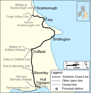
The Hull–Scarborough line, also known as the Yorkshire Coast Line, is a railway line in Yorkshire, England that is used primarily for passenger traffic. It runs northwards from Hull Paragon via Beverley and Driffield to Bridlington, joining the York–Scarborough line at a junction near Seamer before terminating at Scarborough railway station.

The High Huts of the White Mountains are eight mountain huts in the White Mountains of New Hampshire, owned and maintained by the Appalachian Mountain Club. They are modeled after similar huts in the Alps and positioned at intervals along the Appalachian Trail, allowing "thru-hikers" who hike the entire Appalachian Trail to benefit from their services. They are generally separated by six to eight miles, about a day's hike.

The arrondissement of Nîmes is an arrondissement of France in the Gard department in the Occitanie region. It has 180 communes. Its population is 554,624 (2016), and its area is 3,158.1 km2 (1,219.3 sq mi).

Rock Lodge Club is a naturist club located on 145 acres (59 ha) of privately owned land located in the Stockholm area of the Hardyston Township, New Jersey, which is situated on the New Jersey Highlands of North Jersey, about 40 miles (64 km) from Manhattan, New York. Rock Lodge Club and Sky Farm, also based in New Jersey, were founded in 1932 as the first permanent nudist communities in the United States. Both clubs are active today.
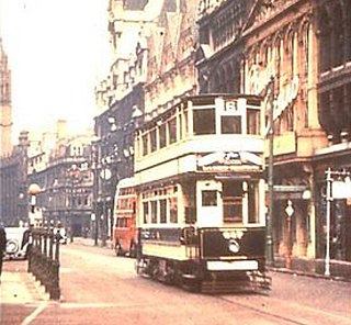
Birmingham Corporation Tramways operated a network of tramways in Birmingham from 1904 until 1953. It was the largest narrow-gauge tramway network in the UK, and was built to a gauge of 3 ft 6 in. It was the fourth largest tramway network in the UK behind London, Glasgow and Manchester.

The Pleasure Point Roadhouse was a historic building on the Monterey Bay, located at 2-3905 East Cliff Dr., 95062 in Santa Cruz County, California. It was torn down on September 27, 2008.

The Coal Creek Historic Mining District is a gold-mining area in the Yukon-Charley Rivers National Preserve of Alaska dating from the 1930s. It features a gold dredge and a supporting community of several dozen buildings, established by mining entrepreneur Ernest Patty.
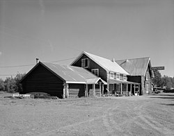
Rika's Landing Roadhouse, also known as Rika's Landing Site or the McCarty Roadhouse, is a roadhouse located at a historically important crossing of the Tanana River, in the Southeast Fairbanks Area, Alaska, United States. It is off mile 274.5 of the Richardson Highway in Big Delta.

The historical buildings and structures of Zion National Park represent a variety of buildings, interpretive structures, signs and infrastructure associated with the National Park Service's operations in Zion National Park, Utah. Structures vary in size and scale from the Zion Lodge to road culverts and curbs, nearly all of which were designed using native materials and regional construction techniques in an adapted version of the National Park Service Rustic style. A number of the larger structures were designed by Gilbert Stanley Underwood, while many of the smaller structures were designed or coordinated with the National Park Service Branch of Plans and Designs. The bulk of the historic structures date to the 1920s and 1930s. Most of the structures of the 1930s were built using Civilian Conservation Corps labor.

The Alcan–Beaver Creek Border Crossing is a border crossing point between the United States and Canada. It is located on the historic Alaska Highway, which was built during World War II for the purpose of providing a road connection between the contiguous United States and Alaska through Canada. Beaver Creek, located on the Canadian side of the border in the Yukon, is the westernmost community in the country.

Southcoates is an urban area in the eastern part of Kingston upon Hull, England.

The Stedman–Thomas Historic District encompasses what was historically the southern portion of Ketchikan, Alaska. It extends along Stedman and Thomas Streets, from Ketchikan Creek in the north to East Street in the south, and includes a few properties on adjacent spur side streets. In the early days of the city, the area was a seasonal Native fishing camp just south of the creek, but the Alaskan gold rushes around the turn of the 20th century brought an influx of settlers to the area.

St Edmund's Church is the Roman Catholic parish church of Godalming, a town in the English county of Surrey. It was built in 1906 to the design of Frederick Walters and is a Grade II listed building. The church stands on a "dramatic hillside site" on the corner of Croft Road just off Flambard Way close to the centre of the town.
Stewart Ranch, also known as Stewart-Hewlett Ranch, near Woodland, Utah in Wasatch and Summit counties, includes eight buildings which were separately listed on the National Register of Historic Places in 1985. The former ranch is located off Utah State Route 35. Some or all of the ranch is included in what is now the Diamond Bar X Ranch.
San Juan City was designated the county seat of Hinsdale County, Colorado when the county was established on February 10, 1874. On February 23, 1875, voters decided to move the county seat to Lake City. The town began as a mining camp, with the goal to become a hub for transportation of supplies to area mines. After a year as the county seat, it became a stage stop, offering food and lodging. It operated as a stage stop, post office, and roadhouse into the 1880s. In 1893, San Juan City became part of Mineral County, Colorado. A post office operated out of San Juan City, off and on, until 1923. The town's site, located along Clear Creek, is now Freemon's Guest Ranch. San Juan Ranch is also said to be the former site of San Juan City, but the former Galloway's transportion hub that became San Juan Ranch was located a few miles away from the town.