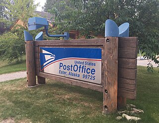
Ester is a census-designated place (CDP) in Fairbanks North Star Borough, Alaska, United States. It is part of the Fairbanks, Alaska Metropolitan Statistical Area. The population in the CDP was 2,422 at the 2010 census, although there are only about a dozen homes in the village itself. The Ester Camp Historic District is a historic district listed on the National Register of Historic Places. Ester was founded as a gold mining camp in the early 1900s, and the economy has focused on mining and services for miners. The Ester Community Association was founded in 1941, and continues to work for the welfare of the community, e.g. establishing and maintaining the Ester Community Park and sponsoring an annual Fourth of July parade. There are several small businesses in Ester, including two saloons, a publishing house, a jewelry maker, hand crafted soap maker and local artisans. The Ester Volunteer Fire Department, John Trigg Ester Library, Ester Historic Society and Ester Post Office serve residents in Ester and surrounding areas. There is also a convenience store and secular chapel on the outskirts of the village. Many artists, writers, and musicians reside in Ester and the local art and music scene has thrived for many years.

Chicken is a U.S. census-designated place in Southeast Fairbanks Census Area, Alaska. It is a community founded on gold mining, and is one of the few surviving gold rush towns in Alaska. The population was 12 at the time of the 2020 census, up from 7 in 2010. However, usually year round, there are 17 inhabitants. Due to mining, Chicken's population peaks during the summer. It has frequently been noted on lists of unusual place names.
The Steese Highway is a highway in the Interior region of the U.S. state of Alaska that extends 161 miles (259 km) from Fairbanks to Circle, a town on the Yukon River about 50 miles (80 km) south of the Arctic Circle. The highway was completed in 1927 and is named for U.S. Army General James G. Steese, a former president of the Alaska Road Commission. It is paved for about the first 81 miles (130 km) and around the town of Central it turns to dirt and gravel. Much of it is narrow and winding.

Yukon–Charley Rivers National Preserve is a United States national preserve located in east central Alaska along the border with Canada. Managed by the National Park Service, the preserve encompasses 130 miles (208 km) of the 1,800-mile (3,000 km) Yukon River and the entire Charley River basin. The preserve protects the undeveloped Charley River and a significant portion of the upper Yukon. The interior Alaskan region experiences extremes of weather, with temperatures that can vary from −50 °F (−46 °C) in winter to 97 °F (36 °C) in summertime. The Yukon provided a means of access to the region, which is entirely roadless, during the late 19th century and early 20th centuries. Gold rushes in Alaska brought prospectors, who operated gold dredges to recover significant quantities of placer gold from area creeks. Today the preserve includes part of the route of the annual Yukon Quest dogsled race, which runs every February. During the summer float trips are popular on the Yukon and Charley Rivers.
Jack Wade is an unincorporated community in Southeast Fairbanks Census Area, Alaska, United States. Its elevation is 2,428 feet (740 m), and it is located along Wade Creek at 64°9′15″N141°27′35″W, about 46 miles (74 km) south of Eagle near the Canada–US border. Founded as a mining camp around 1900, it was named for Jack Anderson and Wade Nelson, the original locators. Jack Wade received a post office in 1901, which remained until 1948.
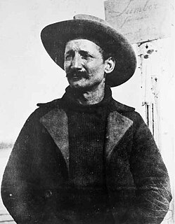
Felice Pedroni, known best to Americans by his Hispanicized alias Felix Pedro, was an Italian immigrant whose discovery of gold in Interior Alaska marked the beginning of the 1902 Fairbanks Gold Rush.

The Fairbanks Gold Rush was a gold rush that took place in Fairbanks, Alaska in the early 1900s. Fairbanks was a city largely built on gold rush fervor at the turn of the 20th century. Discovery and exploration continue to thrive in and around modern-day Fairbanks.

The Coal Creek Historic Mining District is a gold-mining area in the Yukon-Charley Rivers National Preserve of Alaska dating from the 1930s. It features a gold dredge and a supporting community of several dozen buildings, established by mining entrepreneur Ernest Patty.

Goldstream Dredge No. 8 is a ladder dredge operated by the Fairbanks Exploration Company from 1928 to 1959. It is located on the old Steese Highway between Fairbanks and Fox in the central part of Alaska.

Davidson Ditch is a 90-mile (140 km) conduit built in the 1920s to supply water to gold mining dredges in central Alaska. It was the first large-scale pipeline construction project in Alaska, and lessons learned in its construction were applied to the building of the Trans-Alaska Pipeline System. It is eligible for inclusion on the National Register of Historic Places, but has not been listed due to a lack of information. Despite this, the remains of the conduit are partially protected by its inclusion in the White Mountains National Recreation Area.

The history of Fairbanks, the second-largest city in Alaska, can be traced to the founding of a trading post by E.T. Barnette on the south bank of the Chena River on August 26, 1901. The area had seen human occupation since at least the last ice age, but a permanent settlement was not established at the site of Fairbanks until the start of the 20th century.

The Jualpa Mining Camp, also known as the Last Chance Basin Camp, is a former gold mining camp, just outside the city of Juneau, Alaska. Its main building is now operated as the Last Chance Mining Museum by the Gastineau Historical Society. The camp was located on the southern banks of Gold Creek, about 1 mile (1.6 km) north of Juneau, near what is now the end of Basin Road. The camp was the site of one of the largest gold finds in the Juneau mining district. It was established between 1910 and 1913 by the Alaska-Juneau Gold Mining Company and operated until 1944, producing more than $80 million worth of gold. The largest surviving structure of the camp is its air compressor building, which was 84 feet (26 m) long, and still houses the compressor used by the company. Also surviving are a variety of railroad-related resources, which the company used to bring or to its mill on the Gastineau channel, an electrical transformer house, powder magazine, and cable hoist.

The Chicken Historic District encompasses part of the historic mining district of Chicken, Alaska. It is located at milepost 66.5 on the north side of the Taylor Highway, and includes fifteen buildings built between 1908 and 1967. Most of these are single-story wood-frame structures, with either metal or board-and-batten siding, although there are also some log structures. Many of these buildings were erected by the Fairbanks Exploration Company, which ran the gold mining operations in the area. Notable buildings include the bunkhouse, a gabled log structure, and the Chicken Creek Roadhouse, built in 1906, which was originally two stories in height but was reduced to a single story in 1924. The district also includes a section of water pipeline built by the company to bring water to the area from Mosquito Creek, a distance of about 1 mile (1.6 km). The camp was used until the company ended mining operations in 1967.

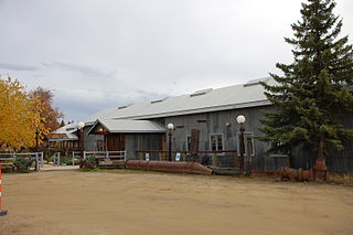
The Chatanika Gold Camp is a historic gold mining camp at Mile 27¾ of the Steese Highway in Chatanika, Alaska. The camp is set on about 49 acres (20 ha) overlooking Cleary Creek, and consists of thirteen buildings as well as a scattering of old mining tools and equipment. The largest of the buildings are two bunkhouses, finished in corrugated metal. The camp was built in 1925 by the Fairbanks Exploration Company (FEC), which also dug the nearby Davidson Ditch to supply water for the operation of the gold dredges. The Chatanika Camp was the largest of the FEC's mining camps in the Fairbanks area. Five of the surviving buildings date to the initial construction period.
The Chena Pump House, also known just as the Pump House Restaurant, is a restaurant at 796 Chena Pump Road in Fairbanks, Alaska. The restaurant is located in the shell of a 1933 pumping station established by the Fairbanks Exploration Company, Alaska's largest gold mining operator at the time. The pump house was used to provide water to dredges operating on Cripple Creek in the Ester area. The building was abandoned by the company in 1958, and was enlarged and converted into a restaurant in 1978. It was listed on the National Register of Historic Places in 1982.

The Discovery Claim on Pedro Creek is a historic gold mining site in central Alaska. It is located at mile 16.5 of the Steese Highway, northeast of Fairbanks. It is a 19-acre (7.7 ha) site on what is now called Pedro Creek, that was where Felix Pedro made the first major discovery of gold in the area on July 22, 1902. His discovery drew large numbers of gold prospectors to the area, and led to the establishment of Fairbanks as a major community in Alaska. Most of the claim site is located south of the highway, which crosses one corner. There is a commemorative marker placed at the side of the highway in 1952. The claim is now owned by the Pioneers of Alaska Igloo #4; there is no substantial evidence of the mining activities that took place there.

The Fairbanks Exploration Company Machine Shop is a historic machine shop in Fairbanks, Alaska, United States. Located behind the Fairbanks Exploration Company administration building at 612 Illinois Street, it is a large single-story steel-frame structure, built in 1927 to serve the company's nearby gold mining operations. Its easternmost section is 16 feet (4.9 m) high, while that on the west is 20 feet (6.1 m) high, in order to accommodate belt-driven equipment and cranes. A tall double door at the center of the east facade is the main entrance. The front of the building housed large belt-driven lathes, while the center had a welding shop, drill presses, and a tool room. A blacksmithy in the back had a sand floor. The building was used by the F.E. Company between 1927 and 1964.
The Fairbanks Exploration Company Dredge No. 2 is a historic gold mining dredge in a remote area of Fairbanks North Star Borough, Alaska, northeast of the city of Fairbanks. It is currently located on the north bank of Fish Creek, shortly northeast of the mouth of Slippery Creek. Its main structure is a compartmented steel hull, 128 feet (39 m) long, 60 feet (18 m) wide, and 12 feet (3.7 m) high, with a 1-2 story superstructure above made of steel and wood framing sheathed in corrugated metal. It has three gantries, and a digging ladder 112 feet (34 m) long at its bow that weights 178,000 pounds (81,000 kg). All of its original operating equipment was reported to be in place in 1999. The dredge was built in 1927 by the Bethlehem Steel Company, and assembled for use in Alaska in 1928. It was operated by the Fairbanks Exploration Company in the Goldstream Valley from 1928 to 1949, and on Fairbanks Creek and lower Fish Creek from 1950 to 1961.
The Fairbanks Exploration Company Gold Dredge No. 5 was a historic gold mining dredge in a remote area of Fairbanks North Star Borough, Alaska, north of the city of Fairbanks. It was last located on Upper Dome Creek, shortly northeast of the mouth of Seattle Creek, about 20 miles (32 km) north of Fairbanks, prior to its being scrapped c. 2012. The dredge was manufactured by the Bethlehem Steel Company in 1928, shipped in pieces to Alaska, and assembled by the Fairbanks Exploration Company on Cleary Creek, where it was used until 1942. It thereafter served on Eldorado Creek (1947–55) and Dome Creek (1955-59) before it was abandoned.

Dredge No. 4 is a wooden-hulled bucketline sluice dredge that mined placer gold on the Yukon River from 1913 until 1959. It is now located along Bonanza Creek Road 13 kilometres (8.1 mi) south of the Klondike Highway near Dawson City, Yukon, where it is preserved as one of the National Historic Sites of Canada. It is the largest wooden-hulled dredge in North America.


