
The Arctic National Wildlife Refuge or Arctic Refuge is a national wildlife refuge in northeastern Alaska, United States, on traditional Iñupiaq and Gwich'in lands. The refuge is 19,286,722 acres (78,050.59 km2) of the Alaska North Slope region, with a northern coastline and vast inland forest, taiga, and tundra regions. ANWR is the largest national wildlife refuge in the country, slightly larger than the Yukon Delta National Wildlife Refuge. The refuge is administered from offices in Fairbanks. ANWR is home to a diverse range of endemic mammal species; notably, it is one of the few North American locations with all three endemic American bears—the polar bear, grizzly bear, and American black bear, each of which resides predominantly in its own ecological niche. Besides the bears, other mammal species include the moose, caribou, wolves, red and Arctic fox, Canada lynx, wolverine, pine marten, American beaver, and North American river otter. Further inland, mountain goats may be seen near the slope. Hundreds of species of migratory birds visit the refuge yearly, and it is a vital, protected breeding location for them. Snow geese, eiders and snowy owls may be observed as well.

Northwest Arctic Borough is a borough located in the U.S. state of Alaska. As of the 2020 census, the population was 7,793, up from 7,523 in 2010. The borough seat is Kotzebue. The borough was formed on June 2, 1986.

The Alaska Peninsula National Wildlife Refuge is a United States National Wildlife Refuge in southwestern Alaska whose use is regulated as an ecological-protection measure. It stretches along the southern coast of the Alaska Peninsula, between the Becharof National Wildlife Refuge on its east and the end of the peninsula at False Pass in the west. In between, however, it is broken into sections by lands of the Aniakchak National Monument and Izembek National Wildlife Refuge. The refuge is administered from offices in King Salmon, Alaska and was established to conserve Alaska Peninsula brown bears, caribou, moose, marine mammals, shorebirds, other migratory birds and fish, and to comply with treaty obligations.

Gates of the Arctic National Park and Preserve is a national park of the United States that protects portions of the Brooks Range in northern Alaska. The park is the northernmost national park in the United States, situated entirely north of the Arctic Circle. The area of the park and preserve is the second largest in the U.S. at 8,472,506 acres ; the National Park portion is the second largest in the U.S., after the National Park portion of Wrangell–St. Elias National Park and Preserve.

The Kobuk River, also known by the names Kooak, Kowak, Kubuk, Kuvuk, and Putnam, is a river located in the Arctic region of northwestern Alaska in the United States. It is approximately 280 miles (451 km) long. Draining a basin with an area of 12,300 square miles (32,000 km2), the Kobuk River is among the largest rivers in northwest Alaska, with widths of up to 1,500 feet and flows reaching speeds of 3–5 miles per hour in its lower and middle reaches. The average elevation for the Kobuk River Basin is 1,300 feet (400 m) above sea level, ranging from sea level at its mouth on the Bering Sea to 11,400 feet near its headwaters in the Brooks Range.

Kobuk Valley National Park is a national park of the United States in the Arctic region of northwestern Alaska, located about 25 miles (40 km) north of the Arctic Circle. The park was designated in 1980 by the Alaska National Interest Lands Conservation Act to preserve the 100 ft (30 m) high Great Kobuk Sand Dunes and the surrounding area which includes caribou migration routes. Park visitors must bring all their own gear for backcountry camping, hiking, backpacking, boating, and dog sledding. No designated trails or roads exist in the park, which at 1,750,716 acres, is slightly larger than the state of Delaware. Kobuk Valley is one of eight national parks in Alaska, the state with the second most national parks, surpassed only by California which has nine. The park is managed by the National Park Service.

Hotham Inlet, also known as Kobuk Lake, is an arm of Kotzebue Sound on the northwestern coast of the U.S. state of Alaska. It is 50 miles (80 km) long and 5–20 miles (8–32 km) wide. The inlet is the outlet of the Kobuk and Selawik Rivers and it is bounded on the southwest by the Baldwin Peninsula.

Noatak National Preserve is a United States National Preserve in northwestern Alaska that was established to protect the Noatak River Basin. The Noatak River system, located just north of the Arctic Circle, is thought to be the last remaining complete river system in the United States that has not been altered by human activities. The roadless basin was proclaimed a United States National Monument in 1978 and a National Preserve in 1980 through the passage of the Alaska National Interest Lands Conservation Act (ANILCA). Noatak National Preserve borders Kobuk Valley National Park on the south and Gates of the Arctic National Park on the east. Unlike the national parks that it borders, sport hunting is allowed in Noatak National Preserve.

Cape Krusenstern National Monument and the colocated Cape Krusenstern Archeological District is a U.S. National Monument and a National Historic Landmark centered on Cape Krusenstern in northwestern Alaska. The national monument was one of fifteen new National Park Service units designated by the Alaska National Interest Lands Conservation Act (ANILCA) of 1980. It was initially declared a national monument under the authority of the Antiquities Act by President Jimmy Carter on December 1, 1978.

The Seney National Wildlife Refuge is a managed wetland in Schoolcraft County in the U.S. state of Michigan. It has an area of 95,212 acres (385 km2). It is bordered by M-28 and M-77. The nearest town of any size is Seney, Michigan. The refuge contains the Seney Wilderness Area and the Strangmoor Bog National Natural Landmark within its boundaries.

Bear River Migratory Bird Refuge is a 74,000-acre (299 km2) National Wildlife Refuge in Utah, established in 1928. The refuge is part of a national system of fee ownership lands purchased from willing sellers, mostly private property owners.

The Yukon Delta National Wildlife Refuge is a United States National Wildlife Refuge covering about 19.16 million acres (77,500 km2) in southwestern Alaska. It is the second-largest National Wildlife Refuge in the country, only slightly smaller than the Arctic National Wildlife Refuge. It is a coastal plain extending to the Bering Sea, covering the delta created by the Yukon and Kuskokwim rivers. The delta includes extensive wetlands near sea level that are often inundated by Bering Sea tides. It is bordered on the east by Wood-Tikchik State Park, the largest state park in the United States. The refuge is administered from offices in Bethel.

Arctic Alaska or Far North Alaska is a region of the U.S. state of Alaska generally referring to the northern areas on or close to the Arctic Ocean.

Alaska occupies the northwestern portion of the North American continent and is bordered only by Canada on the east. It is one of two U.S. states not bordered by another state; Hawaii is the other. Alaska has more ocean coastline than all of the other U.S. states combined. About 500 miles (800 km) of Canadian territory consisting of British Columbia separate Alaska from Washington U.S. state. Alaska is thus an exclave of the United States that is part of the continental U.S. and the U.S. West Coast, but is not part of the contiguous U.S.
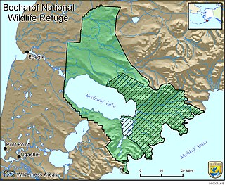
Becharof National Wildlife Refuge is a National Wildlife Refuge in the Aleutian Range of the Alaska Peninsula of southwestern Alaska. It is adjacent to Katmai National Park and Preserve. This national wildlife refuge, which covers an area of 1,200,000 acres (4,900 km2), was established in 1980 to conserve major brown bears, salmon, migratory birds, caribou, marine birds, and mammals and to comply with treaty obligations. It lies primarily in the east-central part of Lake and Peninsula Borough, but extends eastward into the mainland portion of Kodiak Island Borough. The refuge is administered from offices in King Salmon.

The Koyukuk National Wildlife Refuge is a 3,500,000-acre (14,000 km2) conservation area in Alaska. It lies within the floodplain of the Koyukuk River, in a basin that extends from the Yukon River to the Purcell Mountains and the foothills of the Brooks Range. This region of wetlands is home to fish, waterfowl, beaver and Alaskan moose, and wooded lowlands where two species of fox, bears, wolf packs, Canadian lynx and marten prowl.
Tetlin National Wildlife Refuge is a dynamic landscape made up of forests, wetlands, tundra, lakes, mountains and glacial rivers bounded by the snowy peaks of the Alaska Range. This upper Tanana River valley has been called the "Tetlin Passage," because it serves as a major migratory route for birds traveling to and from Canada, the lower 48 and both Central and South America. Many of these birds breed and nest on the refuge. Others pass through on their way to breeding and nesting grounds elsewhere in the state. Migrants, including ducks, geese, swans, cranes, raptors and songbirds, begin arriving in the valley in April, and continue into early June. An estimated 116 species breed on Tetlin during the short summer, when long days and warm temperatures accelerate the growth of plants, insects and other invertebrates, providing a ready source of rich foods for nesting birds.

Togiak National Wildlife Refuge is in the Dillingham and Bethel Census Areas, Alaska. It is dominated by the Ahklun Mountains in the north and the cold waters of Bristol Bay to the south. The natural forces that have shaped this land range from the violent and powerful to the geologically patient. Earthquakes and volcanoes filled the former role, and their marks can still be found, but it was the gradual advance and retreat of glacial ice that carved many of the physical features of this refuge.
The Arctic coastal tundra is an ecoregion of the far north of North America, an important breeding ground for a great deal of wildlife.

The Beringia lowland tundra is a tundra ecoregion of North America, on the west coast of Alaska, mostly covered in wetland.


