Related Research Articles

Aleutians East Borough is a 2nd class borough in the U.S. state of Alaska. As of the 2020 census the borough's population was 3,420. The borough seat is Sand Point.

Kodiak Island Borough is a borough in the U.S. state of Alaska. At the 2020 census, the population was 13,101, down from 13,592 in 2010. The borough seat is Kodiak.

Lake and Peninsula Borough is a borough in the state of Alaska. As of the 2020 census, the population was 1,476, down from 1,631 in 2010. The borough seat of King Salmon is located in neighboring Bristol Bay Borough, although is not the seat of that borough. The most populous community in the borough is the census-designated place of Port Alsworth. With an average of 0.017 inhabitants per square kilometre, the Lake and Peninsula Borough is the second least densely populated organized county-equivalent in the United States; only the unorganized Yukon-Koyukuk Census Area has a lower density.

Yukon–Koyukuk Census Area is a census area in the U.S. state of Alaska. As of the 2020 census, the population was 5,343, down from 5,588 in 2010. With an area of 147,842.51 sq mi (382,910.3 km2), it is the largest of any county or county-equivalent in the United States, or about the same size as the entire state of Montana. It is part of the unorganized borough of Alaska and therefore has no borough seat. Its largest communities are the cities of Galena, in the west, and Fort Yukon, in the northeast.

Unimak Island is the largest island in the Aleutian Islands chain of the U.S. state of Alaska.
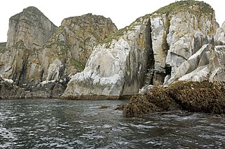
The Shumagin Islands are a group of 20 islands in the Aleutians East Borough south of the mainland of Alaska, United States, at 54°54'–55°20' North 159°15'–160°45' West. The largest islands are Unga Island, Popof Island, Korovin Island, and Nagai Island. Other islands include Andronica, Big Koniuji, Little Koniuji, Simeonof, Chernabura, and Bird. The total land area is 1,192.369 km2 and their total population as of the 2020 census was 578 persons, almost entirely in the city of Sand Point, on Popof Island.

The Alaska Maritime National Wildlife Refuge is a United States National Wildlife Refuge comprising 2,400 islands, headlands, rocks, islets, spires and reefs in Alaska, with a total area of 4.9 million acres (20,000 km2), of which 2.64 million acres (10,700 km2) is wilderness. The refuge stretches from Cape Lisburne on the Chukchi Sea to the tip of the Aleutian Islands in the west and Forrester Island in the southern Alaska Panhandle region in the east. The refuge has diverse landforms and terrains, including tundra, rainforest, cliffs, volcanoes, beaches, lakes, and streams.
The Saint Lazaria Wilderness or St. Lazaria Island is a nesting bird colony located twenty miles (32 km) west of Sitka, Alaska and is a part of the Gulf of Alaska unit of the Alaska Maritime National Wildlife Refuge. It is located in Sitka Sound, just south of Kruzof Island, and within the limits of the City and Borough of Sitka, Alaska. The island's name is Kanasx'ée in the Tlingit language.

The National Wilderness Preservation System (NWPS) of the United States protects federally managed wilderness areas designated for preservation in their natural condition. Activity on formally designated wilderness areas is coordinated by the National Wilderness Preservation System. Wilderness areas are managed by four federal land management agencies: the National Park Service, the U.S. Forest Service, the U.S. Fish and Wildlife Service, and the Bureau of Land Management.
The Krenitzin Islands are a group of small islands located in the eastern portion of the Fox Islands group of the eastern Aleutian Islands, Alaska. The Krenitizins are situated between Unalaska Island to the southwest and Unimak Island to the northeast. Named islands in the Krenitzins group include Aiktak, Avatanak, Derbin, Kaligagan Island (Qisĝagan), Rootok (Aayux̂tax̂), Round, Tigalda, and Ugamak. All of these islands are managed as part of the Aleutian Islands Unit of the Alaska Maritime National Wildlife Refuge. The Krenitzins have a total land area of 61.596 sq.mi. (159.533 km2) and have no population.
The Aleutian Islands Wilderness is a wilderness area in the Aleutian Islands of the U.S. state of Alaska. It is about 1,300,000 acres (5,300 km2) in area and was designated by the United States Congress in 1980. It is part of the Aleutian Islands unit of Alaska Maritime National Wildlife Refuge.
Andreafsky Wilderness is a wilderness area in the U.S. state of Alaska. Located within the Yukon Delta National Wildlife Refuge, it is about 1,300,000 acres (5,300 km2) in area, and was designated by the United States Congress in 1980.
Bering Sea Wilderness is a wilderness area in the U.S. state of Alaska. It is 81,340 acres (32,920 ha) in area and was designated by the United States Congress in 1970. It encompasses St. Matthew Island, Hall Island, and Pinnacle Island and is part of the larger Bering Sea unit of the Alaska Maritime National Wildlife Refuge.

Chamisso Wilderness is a 455-acre (184 ha) wilderness area in the U.S. state of Alaska. It was designated by the United States Congress in 1975.

Forrester Island Wilderness is a 2,832-acre (1,146 ha) wilderness area in the U.S. state of Alaska at Forrester Island. It was designated by the United States Congress in 1970. It is part of the Gulf of Alaska unit of the Alaska Maritime National Wildlife Refuge.

Hazy Islands Wilderness, at 32 acres, is Alaska's smallest wilderness area. It was officially designated as Wilderness in 1970 by the United States Congress. The islands are located west of Coronation Island in the Alaska Panhandle area. Hazy Islands Wilderness comprises five small islands and is home to 10 species of birds, including Brandt's cormorant (Phalacrocorax auritus). It has no anchorages or campsites, and human visitation is discouraged to protect the birds.

The San Juan Islands National Wildlife Refuge is in the San Juan Islands of the Salish Sea, north of Puget Sound, in the State of Washington. Created in 1976, it comprises 83 small, uninhabited islands, scattered throughout the San Juans, with a combined area of approximately 454 acres (1.84 km2). The Refuge is managed by the U.S. Fish and Wildlife Service as one of six in the Washington Maritime National Wildlife Refuge Complex.
The Wisconsin Islands Wilderness is a 29-acre (12 ha) wilderness area located in Door County in northeastern Wisconsin. It is one of the smallest wilderness areas in the United States. Managed by the U.S. Fish & Wildlife Service, the wilderness area is composed of three islands in Lake Michigan.

The Aleutian Islands World War II National Monument is a U.S. national monument in the Aleutian Islands of Alaska. It is located on three islands in the Alaska Maritime National Wildlife Refuge. It was designated as part of World War II Valor in the Pacific National Monument by an executive order of George W. Bush on December 5, 2008, with sites in Alaska, California, and Hawaii. The John D. Dingell, Jr. Conservation, Management, and Recreation Act, signed into law March 12, 2019, separated the national monument into separate units in each state. It is managed by the United States Fish and Wildlife Service.
Washington Maritime National Wildlife Refuge Complex is an administrative grouping of six National Wildlife Refuges in Washington, managed by the United States Fish and Wildlife Service. It includes:
References
- ↑ "Simeonof Wilderness, Alaska". Recreation.gov. Retrieved 2022-10-08.
- ↑ "Simeonof Island". Alaska Guide. Retrieved 2022-10-08.
- ↑ "Wilderness Connect". wilderness.net. Retrieved 2022-10-08.
- ↑ "Simeonof National Wildlife Refuge (U.S. National Park Service)". www.nps.gov. Retrieved 2022-10-08.
- ↑ "Simeonof Wilderness, Alaska". Recreation.gov. Retrieved 2022-10-08.
54°54′N159°16′W / 54.900°N 159.267°W
| | This Alaska location article is a stub. You can help Wikipedia by expanding it. |