
The Bald Knob National Wildlife Refuge is a 15,022 acres (60.79 km2) (2014) wildlife refuge located in White County, Arkansas about two miles south of the town of Bald Knob. The refuge is managed by the United States Fish and Wildlife Service. The refuge features large numbers of migratory waterfowl and bald eagles during the winter months.
The Nowitna River is a 250-mile (400 km) tributary of the Yukon River in the U.S. state of Alaska. The river flows northeast from the Kuskokwim Mountains through Nowitna National Wildlife Refuge and enters the larger river 38 miles (61 km) northeast of Ruby and southwest of Tanana. Major tributaries include the Titna, Big Mud, Little Mud, Lost, and Sulatna rivers.
Montezuma National Wildlife Refuge is a wildlife preserve operated by the United States Fish and Wildlife Service, encompassing part of the Montezuma Swamp at the north end of Cayuga Lake. The 10,004-acre (40.48 km2) preserve is composed of swamps, pools and channels and is a stopping point for migratory birds. It is the largest contiguous wetland complex in the northeastern United States and comprises a portion of the larger Montezuma Wetlands Complex, which is a partnership between the USFWS, the New York State Department of Environmental Conservation, as well as several other non-profit support organizations.

The Shiawassee National Wildlife Refuge is a 9,870.35 acres (39.9439 km2) National Wildlife Refuge in Saginaw County managed by the United States Fish and Wildlife Service. It is located in the central portion of the lower peninsula of the U.S. state of Michigan, approximately 25 miles (40 km) south of the Saginaw Bay in Lake Huron and five miles (8 km) south of the city of Saginaw in the county's Spaulding and James townships. It was established in 1953 to provide habitat for migratory waterfowl.

The Deep Fork National Wildlife Refuge (DFNWR) is part of the United States system of National Wildlife Refuges, and is a critical resource for wildfowl that migrate along the Central Flyway in Spring and Fall. It is located in Eastern Oklahoma, near the city of Okmulgee. The preserve runs along both banks of the Deep Fork River for about 20 miles (32 km). According to TravelOK, DFNWR receives about 45,000 visitors every year.

Ridgefield National Wildlife Refuge is a National Wildlife Refuge and is overseen by the United States Fish and Wildlife Service. The refuge borders the Columbia River and is located west of the city of Ridgefield, Washington. The wildlife haven is split by Lake River. The refuge, which provides a year-round habitat and a migration stop for a variety of bird species, protects more than 5,200 acres (2,100 ha) of marshes, grasslands, and woodlands

The Lower Suwannee National Wildlife Refuge (LSNWR) is part of the United States National Wildlife Refuge System. It is located in southeastern Dixie and northwestern Levy counties on the western coast of Florida, approximately fifty miles southwest of the city of Gainesville.

The Erie National Wildlife Refuge is an 8,777-acre (3,552 ha) National Wildlife Refuge located in Crawford County, Pennsylvania. Named after the Erie tribe, it was established to provide waterfowl and other migratory birds with nesting, feeding, brooding, and resting habitat.

William L. Finley National Wildlife Refuge is a natural area in the Willamette Valley in Oregon, United States. It was created to provide wintering habitat for dusky Canada geese. Unlike other Canada geese, dusky Canada geese have limited summer and winter ranges. They nest on Alaska's Copper River Delta and winter almost exclusively in the Willamette Valley. Habitat loss, predation, and hunting have caused a decrease in population.
Ankeny National Wildlife Refuge is located in the fertile Willamette Valley of northwestern Oregon, 12 miles (19 km) south of Salem. The valley was once a rich mix of wildlife habitats. Valley wetlands were once extensive, with meandering stream channels and vast seasonal marshes. Today, the valley is a mix of farmland and growing cities, with few areas remaining for wildlife.

Baskett Slough National Wildlife Refuge is in northwestern Oregon, 10 miles (16 km) west of Salem in Polk County. The Refuge consists of 1,173 acres (4.75 km2) of cropland, which provide forage for wintering geese, 300 acres (1.2 km2) of forests, 550 acres (2.2 km2) of grasslands, and 500 acres (2.0 km2) of shallow water seasonal wetlands and 35 acres (0.14 km2) of permanent open water. In 1965, Baskett Slough National Wildlife Refuge was created to help ensure some of the original habitat remained for species preservation. The refuge is managed by the U.S. Fish and Wildlife Service, an agency of the U.S. Department of the Interior.
The Atchafalaya National Wildlife Refuge is located about 30 miles (48 km) west of Baton Rouge, Louisiana, and one mile (1.6 km) east of Krotz Springs, Louisiana, lies just east of the Atchafalaya River. In 1988 under the administration of Governor Foster the "Atchafalaya Basin Master Plan" was implemented that combined the 11,780-acre (4,770 ha) Sherburne Wildlife Management Area (WMA), the 15,220-acre (6,160 ha) Atchafalaya National Wildlife Refuge, and the 17,000-acre (6,900 ha) U.S. Army Corps of Engineers' Bayou Des Ourses into the Sherburne Complex Wildlife Management Area.
Catahoula National Wildlife Refuge, located in east central Louisiana, United States, 12 miles (19 km) east of Jena, was established in 1958 as a wintering area for migratory waterfowl. The refuge contains 25,162 acres (101.83 km2) divided into two units. The 6,671-acre (27 km2) Headquarters Unit borders nine miles (14 km) of the northeast shore of Catahoula Lake, a 26,000-acre (110 km2) natural wetland renowned for its large concentrations of migratory waterfowl. The 18,491-acre (74.83 km2) Bushley Bayou Unit, located 8 miles (13 km) west of Jonesville, was established May 16, 2001. This acquisition was made possible through a partnership agreement between The Conservation Fund, American Electric Power, and the Fish and Wildlife Service. The habitat found at the refuge is primarily lowland hardwood forest subject to seasonal backwater flooding from the Ouachita, and Red Rivers. The refuge is located in the Mississippi Alluvial Plain, Southern Backswamps ecoregion.

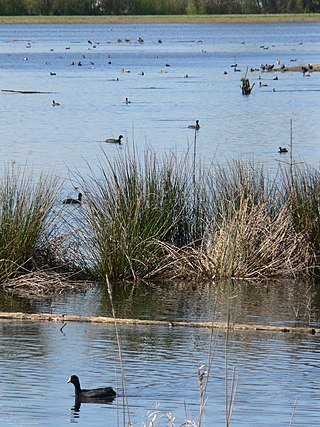
The Sonny Bono Salton Sea National Wildlife Refuge is located in the Imperial Valley of California, 40 miles (64 km) north of the Mexican border. Situated at the southern end of the Salton Sea, the refuge protects one of the most important nesting sites and stopovers along the Pacific Flyway. Despite its location in the Colorado Desert, a subdivision of the larger Sonoran Desert, the refuge contains marine, freshwater, wetland, and agricultural habitats which provide sanctuary for hundreds of birds and wetland species, including several that have been listed as endangered or sensitive by the U.S. Fish and Wildlife Service.

Kanuti National Wildlife Refuge is a national wildlife refuge in central Alaska, United States. One of 16 refuges in Alaska, it was established in 1980 when Congress passed The Alaska National Interest Lands Conservation Act (ANILCA). At 1,640,000 acres (6,600 km2), Kanuti Refuge is about the size of the state of Delaware. Located at the Arctic Circle, the refuge is a prime example of Alaska's boreal ecosystem. It is dominated by black and white spruce, with some white birch and poplars.

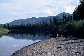
The Koyukuk National Wildlife Refuge is a 3,500,000-acre (14,000 km2) conservation area in Alaska. It lies within the floodplain of the Koyukuk River, in a basin that extends from the Yukon River to the Purcell Mountains and the foothills of the Brooks Range. This region of wetlands is home to fish, waterfowl, beaver and Alaskan moose, and wooded lowlands where two species of fox, bears, wolf packs, Canadian lynx and marten prowl.

Minidoka National Wildlife Refuge is located on the Snake River Plain in south-central Idaho, 12 miles (19 km) northeast of Rupert. It includes about 80 miles (130 km) of shoreline around Lake Walcott, from Minidoka Dam upstream about 25 miles (40 km).

Located in Coos County, New Hampshire, and Oxford County, Maine, Umbagog National Wildlife Refuge is a northern treasure in the National Wildlife Refuge System. The diversity of exceptional habitats provides excellent breeding and foraging areas for migratory birds, endangered species, resident wildlife, and rare plants. The refuge protects over 25,650 acres (103.8 km2) of wetland and forested upland habitat along Umbagog Lake. About 70% of its area is in New Hampshire and 30% in Maine.

Situated along the Pee Dee River, Pee Dee National Wildlife Refuge contains 8,443 acres (34.17 km2) in Anson and Richmond Counties, North Carolina. The refuge was established to provide wintering habitat for migratory waterfowl. The refuge was established in October 1963 to provide habitat for geese and other waterfowl.

The Summer Lake Wildlife Area is a 29.6-square-mile (77 km2) wildlife refuge located on the northwestern edge of the Great Basin drainage in south-central Oregon. It is administered by the Oregon Department of Fish and Wildlife. The refuge is an important stop for waterfowl traveling along the Pacific Flyway during their spring and fall migrations. The Summer Lake Wildlife Area also provides habitat for shorebirds and other bird species as well as wide variety of mammals and several fish species. The Ana River supplies the water for the refuge wetlands.
