The Salmon River, also known as "The River of No Return", is a river located in the U.S. state of Idaho in the western United States. It flows for 425 miles (685 km) through central Idaho, draining a rugged, thinly populated watershed of 14,000 square miles (36,000 km2). The river drops more than 7,000 feet (2,100 m) from its headwaters, near Galena Summit above the Sawtooth Valley in the Sawtooth National Recreation Area, to its confluence with the Snake River. Measured at White Bird, its average discharge is 11,060 cubic feet per second. It is one of the largest rivers in the continental United States without a single dam on its mainstem.

The Delta River is an 80-mile (130 km) tributary of the Tanana River in the U.S. state of Alaska. Its name in the Ahtna language is Saas Na’ . Fed by the Tangle Lakes of the Alaska Range, the river flows north to meet the larger river near Big Delta.

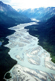
The Andreafsky River is a 120-mile (190 km) tributary of the Yukon River in the U.S. state of Alaska. The Andreafsky flows south from near Iprugalet Mountain in the Yukon Delta National Wildlife Refuge to meet the larger river at Pitkas Point, near the village of St. Mary's.

The Aniakchak River is a stream, 27 miles (43 km) long, in Lake and Peninsula Borough on the Alaska Peninsula in the United States. It arises in Surprise Lake in the crater of Mount Aniakchak, a volcano in the Aleutian Range. It flows eastward from Aniakchak National Monument and Preserve into Aniakchak Bay and the Pacific Ocean.

Beaver Creek is a 180-mile (290 km) tributary of the Yukon River in the U.S. state of Alaska. The creek begins at the confluence of Champion and Bear creeks in the White Mountains National Recreation Area, about 50 miles (80 km) north of Fairbanks. From there it flows west around the southern end of the White Mountains, then northeast into the Yukon Flats National Wildlife Refuge, then west into the Yukon River downstream of Beaver.

Birch Creek is a 150-mile (240 km) tributary of the Yukon River in the U.S. state of Alaska. Beginning at the confluence of Ptarmigan and Eagle creeks near Porcupine Dome, it flows southwest, then south under the Steese Highway and into the Steese National Conservation Area. It then turns east, then north, again passing under the Steese Highway and entering the Yukon Flats National Wildlife Refuge. Turning northwest, it ends where it splits into two distributaries, Lower Mouth Birch Creek and Upper Mouth Birch Creek, near Birch Creek, Alaska. The distributaries flow into the Yukon River at separate locations downstream of Fort Yukon.

The Charley River is an 88-mile (142 km) tributary of the Yukon River in the U.S. state of Alaska. Flowing generally northeast from the Mertie Mountains in the northeastern part of the state, the river lies entirely within Yukon–Charley Rivers National Preserve. The Charley River enters the larger river downstream and 55 miles (89 km) northwest of Eagle.

The Chilikadrotna River is a 55-mile (89 km) tributary of the Mulchatna River in the U.S. state of Alaska. It begins in Lake Clark National Park and Preserve in northern Lake and Peninsula Borough and flows westward into the larger river 46 miles (74 km) northwest of Nondalton.

The Fortymile River is a 60-mile (97 km) tributary of the Yukon River in the U.S. state of Alaska and the Canadian territory of Yukon. Beginning at the confluence of its north and south forks in the Southeast Fairbanks Census Area, the Fortymile flows generally northeast into Canada to meet the larger river 32 miles (51 km) southeast of Eagle, Alaska.
The Gulkana River is a 60-mile (97 km) tributary of the Copper River in the U.S. state of Alaska. Beginning near the southeastern end of Summit Lake in the Alaska Range, the river flows generally south to meet the larger river 9 miles (14 km) northeast of Glennallen. The Richardson Highway and the Trans-Alaska Pipeline run north–south, nearby and roughly parallel to the Gulkana River. Slightly south of Summit Lake the river passes under the east–west Denali Highway near its junction with the Richardson Highway at Paxson.
The Ivishak River is a 95-mile (153 km) tributary of the Sagavanirktok River in the North Slope Borough of the U.S. state of Alaska. Fed by glaciers at the headwaters, the Ivishak flows northeast, then northwest, through the Philip Smith Mountains and the northern foothills of the Arctic National Wildlife Refuge. It enters the Sagavanirktok River on the coastal plain south of Prudhoe Bay.

The John River (Iñupiaq: Atchiiniq) is a 125-mile (201 km) tributary of the Koyukuk River in the northern part of the U.S. state of Alaska. It was named after John Bremner, a prospector and explorer who was one of the first non-native persons to go there. It flows south from Anaktuvuk Pass in Alaska's Brooks Range, into the larger river at a point near Bettles, slightly north of the Arctic Circle.

The Mulchatna River (Dena'ina: Vałts'atnaq') is a 160-mile (260 km) tributary of the Nushagak River in the U.S. state of Alaska. Beginning at Turquoise Lake, it flows generally southwest to meet the larger river 65 miles (105 km) northeast of Dillingham. The Mulchatna's mouth is slightly south (downstream) of the village of Koliganek on the Nushagak, which continues southwest to Nushagak Bay, an arm of Bristol Bay.
The Tinayguk River is a 44-mile (71 km) tributary of the North Fork Koyukuk River in the U.S. state of Alaska. Heading in the Endicott Mountains of the Brooks Range, the river flows generally west then south to meet the larger river about 80 miles (130 km) north of Bettles.
The Tlikakila River is a stream, 51 miles (82 km) long, in the U.S. state of Alaska. The river, lying entirely within Lake Clark National Park, flows southwest from Summit Lake in the Chigmit Mountains of the Aleutian Range to Lake Clark.

The Unalakleet River in the U.S. state of Alaska flows southwest 90 miles (145 km) from the Kaltag Mountains to near the town of Unalakleet, on Norton Sound of the Bering Sea.

The Niobrara National Scenic River is in north-central Nebraska, United States, approximately 300 miles (480 km) northwest of Omaha. In 1991, Congress set aside 76 miles (120 km) for preservation under the management of the National Park Service with assistance from the local Niobrara Council. Several "outstandingly remarkable values" have been designated to be protected along the Niobrara National Scenic River, including: Fish and Wildlife, Scenery, Fossil Resources, Geology, and Recreation. The river was designated by Backpacker magazine as one of the 10 best rivers for canoeing in the United States.
The Anvik River is a 140-mile (230 km) tributary of the Yukon River in the U.S. state of Alaska. It flows southeast from the Nulato Hills to its mouth on the larger river 1.5 miles (2.4 km) north of Anvik.

The Kantishna River is a 108-mile (174 km) tributary of the Tanana River in the U.S. state of Alaska. Formed by the confluence of the McKinley River with Birch Creek in Denali National Park and Preserve, it drains part of the north slope of the Alaska Range including the Denali massif. The direction of flow is generally north-northeast. The Toklat River is a major tributary.

The Nabesna River is a 73-mile (117 km) tributary of the Tanana River in the U.S. state of Alaska. Beginning at Nabesna Glacier in the Alaska Range, it flows north-northeast from Wrangell–St. Elias National Park and Preserve to join the Chisana River near Northway Junction. The combined rivers form the Tanana.