Noatak National Preserve

Last updated

Noatak National Preserve
IUCN category V (protected landscape/seascape)
High Alpine Tundra Noatak National Preserve.jpg
High alpine tundra, Noatak National Preserve (2009)
Relief map of USA Alaska.png
Red pog.svg
Location Northwest Arctic Borough and North Slope Borough, Alaska, US
Nearest city Kotzebue, Alaska
Coordinates 68°00′N159°30′W / 68.000°N 159.500°W / 68.000; -159.500
Area6,569,904 acres (26,587.46 km2) [1]
EstablishedDecember 1, 1978
Visitors31,000(in 2012) [2]
Governing body National Park Service
Website Noatak National Preserve

Noatak National Preserve is a United States National Preserve in northwestern Alaska that was established to protect the Noatak River Basin. The Noatak River system, located just north of the Arctic Circle, is thought to be the last remaining complete river system in the United States that has not been altered by human activities. The roadless basin was proclaimed a United States National Monument in 1978 and a National Preserve in 1980 through the passage of the Alaska National Interest Lands Conservation Act (ANILCA). Noatak National Preserve borders Kobuk Valley National Park on the south and Gates of the Arctic National Park on the east. Unlike the national parks that it borders, sport hunting is allowed in Noatak National Preserve.

Contents

All of the preserve, except for about 700,000 acres (280,000 ha) east of the village of Noatak, has been designated the 5,765,427-acre (2,333,186 ha) Noatak Wilderness. The wilderness is the fourth-largest in the United States, following the Wrangell-Saint Elias Wilderness, the Mollie Beattie Wilderness, and the Gates of the Arctic Wilderness.

Ecology and geology

The preserve includes the transition zone from boreal forest to tundra near the southern edge of the preserve. [3] The Noatak Basin is a transition zone for plants and animals between Arctic and subarctic environments. The lower portion of the Noatak valley has areas of boreal forest, but most vegetation is low-growing tundra species. Alpine tundra occurs at high elevation, and moist tundra, the most common condition, supports cottongrass, willows, Labrador tea, mountain alder, dwarf birch and other tundra species at lower elevations. Boggy areas support cranberry, bog rosemary and salmonberry. [4]

Wildlife of the Noatak tundra includes Alaskan moose, grizzly bears, black bears, wolf packs, Arctic foxes, lemmings, Dall's sheep, vast herds of caribou numbering more than 230,000 individuals, and a variety of birds. Larger birds include Canada geese, tundra swans, white-fronted geese and common, Arctic, yellow-billed and Pacific loons. Predatory birds include rough-legged hawks, gyrfalcons and golden eagles. [4]

The central feature of the preserve is the Noatak River, and is a breeding ground for a variety of commercially important fish. The most widespread salmon species is chum, and pink, chinook and sockeye salmon are found as well. Several kinds of trout are found in deep lakes, with Arctic char and Arctic grayling the most common salmonids in the preserve. Burbot are also found, as are nelma or sheefish, an important species for subsistence fisheries. [4]

The Brooks Range has existed since Cretaceous time, and is composed mainly of shales, limestone and chert, with intrusions of igneous rocks from more recent volcanism. The valleys are composed of limestone, sandstone and siltstone, with deposits of sand, gravel, silt and clay. During the Wisconsonian glaciation the area was incompletely covered by ice, with higher regions glaciated. Permafrost exists in higher regions, becoming patchy at lower levels. [4]

Activities

Since Noatak is a national preserve, both subsistence hunting by local residents and sport hunting by outsiders are permitted in the preserve. If Noatak was a national park, only subsistence hunting would be allowed. [5] Float trips on the Noatak River are a popular way to see the preserve. However, most trips on the Noatak River take place high on the river in Gates of the Arctic National Park, typically from Twelve Mile Creek to Lake Matcherak. Longer trips can continue through the preserve, although the lower river's braided stream presents difficulties beyond Noatak village. There are a few rapids on the river of Class II+, although most of the river is Class I or Class II. Float trip season runs from June or July, when the river thaws, to September. Biting insects are most prevalent in June and July. [6]

Geography

The 6,569,904-acre (2,658,746 ha) [1] preserve extends westward from Gates of the Arctic National Park along the Brooks Range to the north and the Baird Mountains to the south, enclosing the valley of the Noatak River. It is bordered to the north by the National Petroleum Reserve–Alaska. The lower valley of the Noatak is not part of the preserve, separating the preserve from Cape Krusenstern National Monument on the coast. The southeast corner of the preserve runs almost to the coastline at Hotham Inlet. [7] The distance from the headwaters in Gates of the Arctic National Park to Noatak, Alaska is about 354 miles (570 km). [6] Land ownership within the preserve is mostly federal, with 289,973 acres (117,348 ha) owned by native corporations or under easements. [4]

The entire preserve is above the Arctic Circle. Summer weather can have high temperatures of 70 to 80 °F (21 to 27 °C), although snow can occur at any time. [6] The climate is more maritime and temperate on the western side of the park, with harsher, more extreme conditions in the east. [4]

History

Human occupation

Archaeological investigations of the Noatak Valley have found artifacts at sites mostly outside of the preserve. Relatively little has been found within the preserve boundaries. A site just outside the preserve has been dated to 11,700 years before present. Discoveries at Bering Land Bridge National Preserve imply human occupation as far back as 13,000 years ago. Similar extrapolation from sites at Cape Krusenstern and at Onion Portage in the Kobuk Valley imply occupation in later times. In historical times the Naupaktomiut portion of the Inupiat people lived in the lower Noatak valley and the Noatagmuit occupied the middle and upper valley. Hunters from the area of Kotzebue and the Kobuk valley visited the Noatak valley as well. Archaeological remains indicate the presence of villages at lake shores in the preserve during the 1600s, which are believed to have been disrupted by disease-induced population decline brought about by contact with Europeans. The lower Noatak was first explored in 1850 by men from the British survey ship HMS Plover. More surveys took place in 1885. Prospectors arrived in 1898 as a consequence of the Klondike gold rush. In the early 1900s nearly all of the remaining people in the valley concentrated at Noatak. [4]

Administration and designations

Noatak National Monument was proclaimed on December 1, 1978 by President Jimmy Carter using his authority under the Antiquities Act. Carter took the action after the Alaska National Interest Lands Conservation Act (ANILCA) was held up in Congress. In 1980 ANILCA was passed, and was signed into law by Carter on December 2, 1980, converting the monument into a national preserve. No roads enter the preserve. Access is solely by air, boat or walking. [4]

The preserve's headquarters are at the Northwest Arctic Heritage Center in Kotzebue to the west of the park on the Bering Sea coast. [8] Offices and visitor services for Cape Krusenstern National Monument and Kobuk Valley National Park are in the same facility. [9] [10] [11] The units are managed together as the Western Arctic National Parklands, with a single Park Service superintendent in charge. [12]

A 3,035,200-hectare (7,500,000-acre) portion of the Noatak valley was designated a World Biosphere Reserve in 1976, prior to the preserve's establishment, [13] and was withdrawn from the program in June 2017. [14] [15] 330 miles (530 km) of the Noatak, from its source in Gates of the Arctic National Park to the Kelly River in the Noatak National Preserve, were designated a National Wild and Scenic River as part of the ANILCA legislation. [3] [16]

Related Research Articles

<span class="mw-page-title-main">Northwest Arctic Borough, Alaska</span> Borough in Alaska, United States

Northwest Arctic Borough is a borough located in the U.S. state of Alaska. As of the 2020 census, the population was 7,793, up from 7,523 in 2010. The borough seat is Kotzebue. The borough was formed on June 2, 1986.

<span class="mw-page-title-main">Kotzebue, Alaska</span> City in Alaska, United States

Kotzebue or Qikiqtaġruk is a city in the Northwest Arctic Borough in the U.S. state of Alaska. It is the borough's seat, by far its largest community and the economic and transportation hub of the subregion of Alaska encompassing the borough. The population of the city was 3,102 as of the 2020 census, down from 3,201 in 2010.

<span class="mw-page-title-main">Noatak, Alaska</span> Place in Alaska, United States

Noatak is a census-designated place (CDP) in the Northwest Arctic Borough in the U.S. state of Alaska. The population was 570 at the 2020 census, up from 514 in 2010. It is served by Noatak Airport.

<span class="mw-page-title-main">Katmai National Park and Preserve</span> National park in Alaska, United States

Katmai National Park and Preserve is an American national park and preserve in southwest Alaska, notable for the Valley of Ten Thousand Smokes and for its brown bears. The park and preserve encompass 4,093,077 acres, which is between the sizes of Connecticut and New Jersey. Most of the national park is a designated wilderness area. The park is named after Mount Katmai, its centerpiece stratovolcano. The park is located on the Alaska Peninsula, across from Kodiak Island, with headquarters in nearby King Salmon, about 290 miles (470 km) southwest of Anchorage. The area was first designated a national monument in 1918 to protect the area around the major 1912 volcanic eruption of Novarupta, which formed the Valley of Ten Thousand Smokes, a 40-square-mile (100 km2), 100-to-700-foot-deep pyroclastic flow. The park includes as many as 18 individual volcanoes, seven of which have been active since 1900.

<span class="mw-page-title-main">Gates of the Arctic National Park and Preserve</span> National park in Alaska, United States

Gates of the Arctic National Park and Preserve is an American national park that protects portions of the Brooks Range in northern Alaska. The park is the northernmost national park in the United States, situated entirely north of the Arctic Circle. The area of the park and preserve is the second largest in the U.S. at 8,472,506 acres ; the National Park portion is the second largest in the U.S., after the National Park portion of Wrangell–St. Elias National Park and Preserve.

<span class="mw-page-title-main">Kobuk River</span> River in the U.S. state of Alaska

The Kobuk River, also known by the names Kooak, Kowak, Kubuk, Kuvuk, and Putnam, is a river located in the Arctic region of northwestern Alaska in the United States. It is approximately 280 miles (451 km) long. Draining a basin with an area of 12,300 square miles (32,000 km2), the Kobuk River is among the largest rivers in northwest Alaska, with widths of up to 1,500 feet and flows reaching speeds of 3–5 miles per hour in its lower and middle reaches. The average elevation for the Kobuk River Basin is 1,300 feet (400 m) above sea level, ranging from sea level at its mouth on the Bering Sea to 11,400 feet near its headwaters in the Brooks Range.

<span class="mw-page-title-main">Glacier Bay National Park and Preserve</span> National park in Alaska, United States

Glacier Bay National Park and Preserve is an American national park located in Southeast Alaska west of Juneau. President Calvin Coolidge proclaimed the area around Glacier Bay a national monument under the Antiquities Act on February 26, 1925. Subsequent to an expansion of the monument by President Jimmy Carter in 1978, the Alaska National Interest Lands Conservation Act (ANILCA) enlarged the national monument by 523,000 acres on December 2, 1980, and created Glacier Bay National Park and Preserve. The national preserve encompasses 58,406 acres of public land to the immediate northwest of the park, protecting a portion of the Alsek River with its fish and wildlife habitats, while allowing sport hunting.
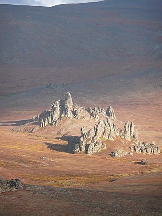
<span class="mw-page-title-main">Kobuk Valley National Park</span> National park in Alaska, United States

Kobuk Valley National Park is an American national park in the Arctic region of northwestern Alaska, located about 25 miles (40 km) north of the Arctic Circle. The park was designated in 1980 by the Alaska National Interest Lands Conservation Act to preserve the 100 ft (30 m) high Great Kobuk Sand Dunes and the surrounding area which includes caribou migration routes. Park visitors must bring all their own gear for backcountry camping, hiking, backpacking, boating, and dog sledding. No designated trails or roads exist in the park, which at 1,750,716 acres, is slightly larger than the state of Delaware. Kobuk Valley is one of eight national parks in Alaska, the state with the second most national parks, surpassed only by California which has nine. The park is managed by the National Park Service.

<span class="mw-page-title-main">Lake Clark National Park and Preserve</span> National park in southwest Alaska, United States

Lake Clark National Park and Preserve is an American national park in southwest Alaska, about 100 miles (160 km) southwest of Anchorage. The park was first proclaimed a national monument in 1978, then established as a national park and preserve in 1980 by the Alaska National Interest Lands Conservation Act. The park includes many streams and lakes vital to the Bristol Bay salmon fishery, including its namesake Lake Clark. A wide variety of recreational activities may be pursued in the park and preserve year-round. The park protects rainforests along the coastline of Cook Inlet, alpine tundra, glaciers, glacial lakes, major salmon-bearing rivers, and two volcanoes, Mount Redoubt and Mount Iliamna. Mount Redoubt is active, erupting in 1989 and 2009. The wide variety of ecosystems in the park mean that virtually all major Alaskan animals, terrestrial and marine, may be seen in and around the park. Salmon, particularly sockeye salmon, play a major role in the ecosystem and the local economy. Large populations of brown bears are attracted to feed on the spawning salmon in the Kijik River and at Silver Salmon Creek. Bear watching is a common activity in the park.

<span class="mw-page-title-main">Alaska National Interest Lands Conservation Act</span> United States federal law providing protection to certain areas in Alaska

The Alaska National Interest Lands Conservation Act (ANILCA) is a United States federal law signed by President Jimmy Carter on December 2, 1980. ANILCA provided varying degrees of special protection to over 157,000,000 acres (64,000,000 ha) of land, including national parks, national wildlife refuges, national monuments, wild and scenic rivers, recreational areas, national forests, and conservation areas. It was, and remains to date, the single largest expansion of protected lands in history and more than doubled the size of the National Park System.

<span class="mw-page-title-main">Hotham Inlet</span>

Hotham Inlet, also known as Kobuk Lake, is an arm of Kotzebue Sound on the northwestern coast of the U.S. state of Alaska. It is 50 miles (80 km) long and 5–20 miles (8–32 km) wide. The inlet is the outlet of the Kobuk and Selawik Rivers and it is bounded on the southwest by the Baldwin Peninsula.

<span class="mw-page-title-main">Noatak River</span> River in the northwestern Alaska

The Noatak River is a river in the northwestern part of the U.S. state of Alaska.

<span class="mw-page-title-main">Cape Krusenstern National Monument</span> U.S. National Monument and National Historic Landmark

Cape Krusenstern National Monument and the colocated Cape Krusenstern Archeological District is a U.S. National Monument and a National Historic Landmark centered on Cape Krusenstern in northwestern Alaska. The national monument was one of fifteen new National Park Service units designated by the Alaska National Interest Lands Conservation Act (ANILCA) of 1980. It was initially declared a national monument under the authority of the Antiquities Act by President Jimmy Carter on December 1, 1978.

<span class="mw-page-title-main">Selawik National Wildlife Refuge</span> Nature reserve in Alaska

Selawik National Wildlife Refuge in northwest Alaska in the Waring Mountains was officially established in 1980 with the passage of the Alaska National Interest Lands Conservation Act (ANILCA).

<span class="mw-page-title-main">Bering Land Bridge National Preserve</span>

The Bering Land Bridge National Preserve is one of the most remote Protected areas of the United States, located on the Seward Peninsula. The National Preserve protects a remnant of the Bering Land Bridge that connected Asia with North America more than 13,000 years ago during the Pleistocene ice age. The majority of this land bridge now lies beneath the waters of the Chukchi and Bering Seas. During the glacial epoch this bridge was a migration route for people, animals, and plants whenever ocean levels fell enough to expose the land bridge. Archeologists disagree whether it was across this Bering Land Bridge, also called Beringia, that humans first migrated from Asia to populate the Americas, or whether it was via a coastal route.

<span class="mw-page-title-main">Gates of the Arctic Wilderness</span> Alaskan nature reserve

Gates of the Arctic Wilderness is a wilderness area in the U.S. state of Alaska. Located in the Gates of the Arctic National Park and Preserve, it is 7,245,600-acre (2,932,200 ha) in area, the third-largest designated wilderness area in the United States.

<span class="mw-page-title-main">Arctic Alaska</span> Northern region of Alaska

Arctic Alaska or Far North Alaska is a region of the U.S. state of Alaska generally referring to the northern areas on or close to the Arctic Ocean.

The Murie Science and Learning Center is a collaboration between the Denali National Park and Preserve, seven additional National Parks and several park partners.." The Murie Science and Learning Center promotes scientific research to aid park managers and provide science-based education programs and information to students, educational institutions and the visiting public.

<span class="mw-page-title-main">Baird Mountains</span> Mountain range in Alaska, United States

The Baird Mountains are a mountain range located northeast of the Kotzebue Sound, in between the Kobuk and Noatak Rivers in Alaska. The range was named after Smithsonian Institution Secretary Spencer F. Baird.

<span class="mw-page-title-main">Western Arctic National Parklands</span>

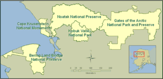
The Western Arctic National Parklands describes four United States National Park Service units in western Alaska that are managed by a single park superintendent and their staff. The western Arctic parklands are Kobuk Valley National Park, Noatak National Preserve, Cape Krusenstern National Monument, and Bering Land Bridge National Preserve. The four units have a total area of about 11,000,000 acres (4,500,000 ha) and are managed from the Northwest Arctic Heritage Center in Kotzebue, Alaska. Bering Land Bridge National Preserve has administrative offices in Nome.

References

  1. 1 2 "Listing of acreage – December 31, 2011" (XLSX). Land Resource Division, National Park Service. Retrieved March 7, 2012. (National Park Service Acreage Reports)
  2. "NPS Annual Recreation Visits Report". National Park Service. Retrieved February 21, 2013.
  3. 1 2 "Nature & Science". Noatak National Preserve. National Park Service. Retrieved February 21, 2013.
  4. 1 2 3 4 5 6 7 8 "Noatak National Preserve". National Park Service. Retrieved February 22, 2013.
  5. "Hunting". Noatak National Preserve. National Park Service. Retrieved February 21, 2013.
  6. 1 2 3 "Floating". Noatak National Preserve. National Park Service. Retrieved February 21, 2013.
  7. "Map of Noatak National Preserve". National Park Service.{{cite web}}: Missing or empty |url= (help)
  8. "Operating Hours and Seasons". Noatak National Preserve. National Park Service. Retrieved February 21, 2013.
  9. "Operating Hours and Seasons". Kobuk Valley National Park. National Park Service. Retrieved February 21, 2013.
  10. "Operating Hours and Seasons". Cape Krusenstern National Monument. National Park Service. Retrieved February 21, 2013.
  11. "Northwest Arctic Heritage Center, Kotzebue, Alaska". Kobuk Valley National Park. National Park Service. Retrieved February 21, 2013.
  12. Quinley, John. "Superintendent Named for Western Arctic National Parklands". Kobuk Valley National Park. National Park Service. Retrieved February 21, 2013.
  13. "Noatak". Biosphere Reserve Information. UNESCO. Retrieved February 21, 2013.
  14. UNESCO. "Biosphere Reserves: Europe & North America" . Retrieved September 2, 2018.
  15. "23 new sites added to UNESCO's World Network of Biosphere Reserves". June 14, 2017. Retrieved September 2, 2018.
  16. "Noatak River, Alaska". National Wild and Scenic Rivers System. Archived from the original on February 16, 2013. Retrieved February 21, 2013.