Noatak, Alaska

Last updated

Noatak
Inupiaq: Nuataaq
CDP
Noatak village on the Noatak river.jpg
Aerial view of a portion of Noatak village
Northwest Arctic Borough Alaska incorporated and unincorporated areas Noatak highlighted.svg
Location in Northwest Arctic Borough and the state of Alaska.
Coordinates: 67°34′19″N162°58′30″W / 67.57194°N 162.97500°W / 67.57194; -162.97500
Country United States
State Alaska
Borough Northwest Arctic
Government
  Borough mayor Dickie Moto
   State senator Donny Olson (D)
   State rep. Tom Baker (R)
Area
[1]
  Total16.85 sq mi (43.65 km2)
  Land16.03 sq mi (41.52 km2)
  Water0.82 sq mi (2.13 km2)
Population
 (2020)
  Total570
  Density35.55/sq mi (13.73/km2)
Time zone UTC-9 (Alaska (AKST))
  Summer (DST) UTC-8 (AKDT)
ZIP code
99761
Area code 907
FIPS code 02-54700

Noatak (Inupiaq : Nuataaq) is a census-designated place (CDP) in the Northwest Arctic Borough in the U.S. state of Alaska. The population was 570 at the 2020 census, up from 514 in 2010. It is served by Noatak Airport.

Contents

History

Inuit in kayaks, Noatak Noatak-Alaska01.jpg
Inuit in kayaks, Noatak

Noatak was established as a fishing and hunting camp in the 1800s. Two identifiable groups of Inupiat resided on the Noatak River. The Nautaaġmiut (called "Noatagamut" in the 1880 census), Inupiaq for "inland river people", lived upriver, and the Napaaqtuġmiut, meaning "people of the trees", lived downriver. By the early 20th century, the missionaries Robert and Carrie Samms settled in what they called "Noatak". A United States post office was established in 1940.

Geography

Noatak is located at 67°34′19″N162°58′30″W / 67.57194°N 162.97500°W / 67.57194; -162.97500 (67.572031, -162.975085). [2]

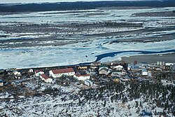
Noatak is located on the west bank of the Noatak River, 81 km (50 mi) north of Kotzebue. It is 102 km (63 mi) north of the Arctic Circle. Noatak village lies near the western boundary of the 6.6-million acre (270,000 km2) Noatak National Preserve and is the only settlement on the over-400-mile (640 km) long Noatak River.

According to the United States Census Bureau, the CDP has a total area of 12.2 square miles (32 km2), of which, 11.6 square miles (30 km2) of it is land and 0.7 square miles (1.8 km2) of it (5.40%) is water.

Demographics

Historical population
CensusPop.Note
1880 400
1910 121
1920 16435.5%
1930 21229.3%
1940 33658.5%
1950 326−3.0%
1960 275−15.6%
1970 2936.5%
1980 273−6.8%
1990 33322.0%
2000 42828.5%
2010 51420.1%
2020 57010.9%
U.S. Decennial Census [3]

Noatak first appeared on the 1880 U.S. Census as an unincorporated Inuit village of "Noatagamute." [4] All 400 of its residents were Inuit. [5] It did not return again until 1910, this time as Noatak. It has returned on every successive census to date. It was made a census-designated place (CDP) in 1980.

As of the census [6] of 2000, there were 428 people, 100 households, and 90 families residing in the CDP. The population density was 37.0 inhabitants per square mile (14.3/km2). There were 106 housing units at an average density of 9.2 per square mile (3.6/km2). The racial makeup of the CDP was 3.74% White, 0.23% Black or African American, 93.69% Native American, and 2.34% from two or more races. 0.23% of the population were Hispanic or Latino of any race.

Inuit man, Noatak Inuit man by Curtis - Noatak AK.jpg
Inuit man, Noatak

There were 100 households, out of which 69.0% had children under the age of 18 living with them, 56.0% were married couples living together, 22.0% had a female householder with no husband present, and 10.0% were non-families. 9.0% of all households were made up of individuals, and none had someone living alone who was 65 years of age or older. The average household size was 4.28 and the average family size was 4.51.

In the CDP, the population was spread out, with 42.5% under the age of 18, 10.5% from 18 to 24, 28.7% from 25 to 44, 12.9% from 45 to 64, and 5.4% who were 65 years of age or older. The median age was 23 years. For every 100 females, there were 104.8 males. For every 100 females age 18 and over, there were 108.5 males.

The median income for a household in the CDP was $30,833, and the median income for a family was $31,667. Males had a median income of $25,833 versus $21,250 for females. The per capita income for the CDP was $9,659. About 25.0% of families and 22.0% of the population were below the poverty line, including 21.9% of those under age 18 and 13.6% of those age 65 or over.

Transportation

Noatak has a 4,000-foot (1,200 m) gravel public airstrip and is primarily reached by air. No road goes to Noatak. Snowmobiles, ATV's, and small boats are important means of inter-village travel and for local subsistence activities. [7]

Facilities

The Napaaqtugmiut School, operated by the Northwest Arctic Borough School District, serves the community. Its current building opened in 2008. As of 2017 it had 177 students, with Alaska Natives making up 95% of the student body. [8]

See also

Related Research Articles

<span class="mw-page-title-main">North Slope Borough, Alaska</span> Borough in Alaska, United States

The North Slope Borough is the northernmost borough in the US state of Alaska and thus, the northernmost county or equivalent of the United States as a whole. As of the 2020 census, the population was 11,031. The borough seat and largest city, comprising nearly 1/2 of the borough’s population, is Utqiaġvik, the northernmost settlement in the United States.

<span class="mw-page-title-main">Northwest Arctic Borough, Alaska</span> Borough in Alaska, United States

Northwest Arctic Borough is a borough located in the U.S. state of Alaska. As of the 2020 census, the population was 7,793, up from 7,523 in 2010. The borough seat is Kotzebue. The borough was formed on June 2, 1986.

<span class="mw-page-title-main">Goodnews Bay, Alaska</span> City in Alaska, United States

Goodnews Bay is a city in Bethel Census Area, Alaska, United States. As of the 2010 census, the population of the city was 243, up from 230 in 2000.

<span class="mw-page-title-main">Kasigluk, Alaska</span> Census-designated place in Alaska, United States

Kasigluk is a census-designated place (CDP) in the Bethel Census Area in the U.S. state of Alaska. At the 2010 census the population was 569, up from 543 in 2000. Kasigluk consists of two smaller villages, called Akiuk and Akula.

<span class="mw-page-title-main">Kongiganak, Alaska</span> CDP in Alaska, United States

Kongiganak is a census-designated place (CDP) in Bethel Census Area, Alaska, United States, and primarily sits on the eastern shore of the Kongiganak River. As of the 2010 census, the population was 439, up from 359 in 2000.

<span class="mw-page-title-main">Tuluksak, Alaska</span> CDP in Alaska, United States

Tuluksak is a census-designated place (CDP) in Bethel Census Area, Alaska, United States. At the 2010 census the population was 373, down from 428 in 2000.

<span class="mw-page-title-main">Naknek, Alaska</span> Place in Alaska

Naknek is a census-designated place located in and the borough seat of Bristol Bay Borough in the U.S. state of Alaska. As of the 2020 census, the population of the CDP was 470, down from 544 in 2010.

<span class="mw-page-title-main">Karluk, Alaska</span> Census-designated place in Alaska, United States

Karluk is a census-designated place (CDP) in Kodiak Borough, Kodiak Island, Alaska, United States. The population was 37 at the 2010 census, up from 27 in 2000.

St. Michael, historically referred to as Saint Michael, is a city in Nome Census Area, Alaska. The population was 401 at the 2010 census, up from 368 in 2000.

<span class="mw-page-title-main">Unalakleet, Alaska</span> City in Alaska, United States

Unalakleet is a city in Nome Census Area, Alaska, United States, in the western part of the state. At the 2010 census the population was 688, down from 747 in 2000. Unalakleet is known in the region and around Alaska for its salmon and king crab harvests; the residents rely for much of their diet on caribou, ptarmigan, oogruk, and various salmon species.

<span class="mw-page-title-main">Point Lay, Alaska</span> CDP in Alaska, United States

Point Lay is a census-designated place (CDP) in North Slope Borough, Alaska, United States. At the 2020 census the population was 330, up from 189 in 2010.

<span class="mw-page-title-main">Ambler, Alaska</span> City in Alaska, United States

Ambler is a city in Northwest Arctic Borough, Alaska, United States. At the 2010 census the population was 258, down from 309 in 2000. The city is located in the large Iñupiaq language speaking region of Alaska, and the local dialect is known as the Ambler dialect. As of 1999, over 91% of the community speaks and understands the language, with many young children actively learning the language in school. It has important relationships with the "hub" city of Kotzebue, Alaska and has important relationships with Maniilaq Health Association.

<span class="mw-page-title-main">Deering, Alaska</span> City in Alaska, United States

Deering is a city in the Northwest Arctic Borough in the U.S. state of Alaska. It is located on a sandy spit on the Seward Peninsula where the Inmachuk River flows into Kotzebue Sound, 92 km (57 mi) southwest of Kotzebue.

<span class="mw-page-title-main">Kotzebue, Alaska</span> City in Alaska, United States

Kotzebue or Qikiqtaġruk is a city in the Northwest Arctic Borough in the U.S. state of Alaska. It is the borough's seat, by far its largest community and the economic and transportation hub of the subregion of Alaska encompassing the borough. The population of the city was 3,102 as of the 2020 census, down from 3,201 in 2010.

<span class="mw-page-title-main">Noorvik, Alaska</span> City in Alaska, United States

Noorvik is an Iñupiat city in the Northwest Arctic Borough in the U.S. state of Alaska. As of the 2020 census, the population of the city was 694, up from 668 in 2010. Located in the NANA Region Corp, Noorvik has close ties with the largest city in the region, Kotzebue. Residents speak a dialect of Iñupiaq known as Noorvik Inupiaq. Noorvik was the first town to be counted in the 2010 census.

<span class="mw-page-title-main">Red Dog Mine, Alaska</span> Census-designated place in Alaska, United States

Red Dog Mine is a census-designated place (CDP) in the Northwest Arctic Borough of the U.S. state of Alaska. The population was 5 at the 2020 census, down from 309 in 2010.

<span class="mw-page-title-main">Selawik, Alaska</span> City in Alaska, United States

Selawik is a city in Northwest Arctic Borough, Alaska, United States. At the 2010 census the population was 829, up from 772 in 2000.

Marshall is a city in Kusilvak Census Area, Alaska, United States. At the 2010 census the population was 414, up from 349 in 2000.

<span class="mw-page-title-main">Arctic Village, Alaska</span> CDP in Alaska, United States

Arctic Village is an unincorporated Native American village and a census-designated place (CDP) in Yukon-Koyukuk Census Area, Alaska, United States. As of the 2010 census, the population of the CDP was 152. This was unchanged from 2000. The village is located in the large Gwitch'in speaking region of Alaska, and the local dialect is known as Di'haii Gwitch'in or shahanh. As of 1999, over 95% of the community speaks and understands the language. As of 2019, the second village chief was against oil drilling because of the impact on caribou.

<span class="mw-page-title-main">Wiseman, Alaska</span> CDP in Alaska, United States

Wiseman is a census-designated place (CDP) in Yukon-Koyukuk Census Area, Alaska, United States. The full time resident population is 12 as of 2022.

References

  1. "2020 U.S. Gazetteer Files". United States Census Bureau. Retrieved October 29, 2021.
  2. "US Gazetteer files: 2010, 2000, and 1990". United States Census Bureau. February 12, 2011. Retrieved April 23, 2011.
  3. "U.S. Decennial Census". Census.gov. Retrieved June 6, 2013.
  4. "Geological Survey Professional Paper". 1949.
  5. "Statistics of the Population of Alaska" (PDF). United States Census Bureau. 1880.
  6. "U.S. Census website". United States Census Bureau . Retrieved January 31, 2008.
  7. Archived December 23, 2007, at the Wayback Machine Maniilaq Association Noatak page
  8. Home. Napaaqtugmiut School. Retrieved on March 26, 2017.