Related Research Articles

Prince of Wales–Hyder Census Area is a census area located in the U.S. state of Alaska. As of the 2010 census, the population was 5,559. It is part of the unorganized borough and therefore has no borough seat. Its largest communities are Craig and Metlakatla. It was formerly part of the Census Bureau's Prince of Wales–Outer Ketchikan Census Area, but the name was changed in 2008 after most of the Outer Ketchikan was lost to annexation by the Ketchikan Gateway Borough.

The City and Borough of Wrangell is a borough in Alaska, United States. As of the 2010 census the population was 2,369, up from 2,308 in 2000.

The Tongass National Forest in Southeast Alaska is the largest U.S. National Forest at 16.7 million acres. Most of its area is temperate rain forest and is remote enough to be home to many species of endangered and rare flora and fauna. The Tongass, which is managed by the United States Forest Service, encompasses islands of the Alexander Archipelago, fjords and glaciers, and peaks of the Coast Mountains. An international border with Canada runs along the crest of the Boundary Ranges of the Coast Mountains. The forest is administered from Forest Service offices in Ketchikan. There are local ranger district offices located in Craig, Hoonah, Juneau, Ketchikan, Petersburg, Sitka, Thorne Bay, Wrangell, and Yakutat.

The Dixon Entrance is a strait about 80 kilometers (50 mi) long and wide in the Pacific Ocean at the Canada–United States border, between the U.S. state of Alaska and the province of British Columbia in Canada. The Dixon Entrance is part of the Inside Passage shipping route. It forms part of the maritime boundary between the U.S. and Canada, although the location of that boundary here is disputed.
Admiralty Island is an island in the Alexander Archipelago in Southeast Alaska, at 57°44′N134°20′W. It is 145 km (90 mi) long and 56 km (35 mi) wide with an area of 4,264.1 km2 (1,646.4 sq mi), making it the seventh-largest island in the United States and the 132nd largest island in the world. It is one of the ABC islands in Alaska. The island is nearly cut in two by the Seymour Canal; to its east is the long, narrow Glass Peninsula. Most of Admiralty Island—955,747 acres (3,868 km2) —is protected as the Admiralty Island National Monument administered by the Tongass National Forest. The Kootznoowoo Wilderness encompasses vast stands of old-growth temperate rainforest. These forests provide some of the best habitat available to species such as brown bears, bald eagles, and Sitka black-tailed deer.

Etolin Island is an island in the Alexander Archipelago of southeastern Alaska, United States at 56°05′52″N132°21′37″W. It is between Prince of Wales Island, to its west, and the Alaska mainland, to its east. It is southwest of Wrangell Island. It was first charted in 1793 by James Johnstone, one of George Vancouver's officers during his 1791-95 expedition. He only charted its southwest and east coasts, not realizing it was an island. It was originally named Duke of York Island but was renamed by the United States after the Alaska Purchase. It is named after Adolf Etolin, governor of the Russian American colonies from 1840 to 1845.

Forrester Island Wilderness is a 2,832-acre (1,146 ha) wilderness area in the U.S. state of Alaska at Forrester Island. It was designated by the United States Congress in 1970. It is part of the Gulf of Alaska unit of the Alaska Maritime National Wildlife Refuge.
Warren Island is an island in the Alexander Archipelago of southeastern Alaska, United States. It lies on the Pacific coast just southwest of the community of Edna Bay. Directly west is Coronation Island and directly north is Kuiu Island. Warren Island has a land area of 47.191 km2 and no permanent resident population. The entire island has been designated as the Warren Island Wilderness, a part of Tongass National Forest.

Coronation Island is located in Alaska off the northwest coast of Prince of Wales Island, south of Kuiu Island, and north of Noyes Island. High prevailing winds and waves from the open ocean to the west, combined with a steep, rocky coast, result in virtually unaccessible shore due to heavy surf along the windward coastline of the island. The few protected coves and beaches along the leeward shore are guarded by rocky shoals. Thus, the island is difficult to access by any route, and is generally limited to small boat or floatplane during brief lulls in the weather. There are no developed facilities and no groomed trails on the island. Wilderness camping is unrestricted and fishing and hunting are allowed. The nearest full-service community is Craig, Alaska. The island is also home to the Coronation Island Wilderness, which encompasses 19,232 acres (78 km2) and includes the adjacent Spanish Islands. There are several sea caves on the island, and some of these contain fossils.

The Stikine-LeConte Wilderness is on the mainland of southeast Alaska, southeast of Petersburg and north of Wrangell, Alaska. The boundary extends from Frederick Sound on the west to the Alaska–Canada boundary on the east. The wilderness is 448,841 acres (181,640 ha) in size. It is part of Tongass National Forest, which is managed by the United States Forest Service.
Karta River Wilderness is a U. S. wilderness area within the Tongass National Forest, centrally located on Prince of Wales Island. It is 8 miles (13 km) north of Hollis, Alaska just east of the Kasaan Peninsula and may be accessed by a quick 10-minute plane ride or 30-minute boat ride. The wilderness was established by Congress in 1990, as part of the Tongass Timber Reform Act.

The temperate rainforests of Admiralty Island's Kootznoowoo Wilderness are unique among the 5,700,000 acres (2,300,000 ha) of federally protected Wilderness in Southeast Alaska.

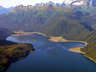
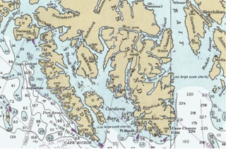
Cordova Bay is a bay in the Alexander Archipelago of southeast Alaska. It opens onto Dixon Entrance to the south, between Cape Muzon on Dall Island and Point Marsh. The name Puerto Cordova y Cordova was given by the Spanish explorer Lieutenant Don Jacinto Caamaño in 1792, in honor of Admiral Luis de Córdova y Córdova. The name was published by George Vancouver in 1798.
Hetta Inlet is a deep embayment in the southwestern coast of Prince of Wales Island in the U.S. state of Alaska. It connects with the Pacific Ocean through Cordova Bay. The head of the inlet is separated by a 200 feet (61 m) divide from the West Arm of Cholmondeley Sound. The shores are abrupt from the water's edge, and the channels and inlets are deep. The precipitation is probably a little greater than at Ketchikan, and the mean annual temperature is slightly higher. The white crystalline limestone of the Wales series, striking nearly north and south, is the predominant country rock of Hetta Inlet. In it are intruded many igneous rocks, some schistose, some massive. The white limestones are closely folded and have great variation in dip. The igneous rocks, so far as determined from the small collection made, include gabbros, diorites, amphibolites, diabases, and pyroxene-syenites. All these are comparatively massive. The greenstoneschists, which occupy considerable areas, are chloritic.
The West Chichagof-Yakobi Wilderness is a federally designated wilderness. It encompasses 265,286 acres (107,357 ha) in Southeastern Alaska, in the United States. It includes Yakobi Island and the entire western side of Chichagof Island, as well as the many small island systems along their coasts.
The South Baranof Wilderness is a federally designated wilderness area within the Tongass National Forest, located on Baranof Island, Alaska. Covering 319,568 acres south of Sitka, the South Baranof protects glacier-carved fjords, hanging valleys, old-growth temperate rainforests and sheer granite mountains.

Forrester Island is an island in the U.S. state of Alaska. It is located off the coast of the Alaska Panhandle, near its southernmost portion, 20 miles (32 km) west of Dall Island, in the Prince of Wales-Hyder Census Area. The island is 5.2 miles (8.4 km) long and covers an area of 3.97 sq mi (10.29 km2). It is wooded and mountainous, rising 814 feet (248 m) in elevation.

The Petersburg Creek–Duncan Salt Chuck Wilderness is a designated wilderness area located on Kupreanof Island, Alaska, within the Tongass National Forest. Created in 1980 by the Alaska National Interest Lands Conservation Act, the wilderness area protects 46,849 acres of temperate rainforests, salt marsheses and rugged, glacier-carved mountains.
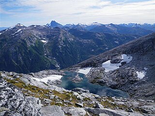
Lakes named Summit Lake in Alaska include:
The South Etolin Wilderness is a wilderness area within the Tongass National Forest of Alaska. The designated wilderness encompasses 82,676 acres, including much of Etolin Island along with several smaller islands, all of which are part of the Alexander Archipelago. Designated in 1990 by the Tongass Timber Reform Act, the wilderness protects classic Southeast Alaska temperate rainforest ecosystems, rising from the densely-forested coast to the glacially-carved summit of 3,720-foot Mount Etolin. An introduced population of Roosevelt elk provides a unique hunting opportunity, both for sport and subsistence purposes.
References
Coordinates: 54°56′22″N132°20′05″W / 54.93944°N 132.33472°W
| | This article related to a protected area in Alaska is a stub. You can help Wikipedia by expanding it. |
| | This article about a location in the Prince of Wales–Hyder Census Area, Alaska is a stub. You can help Wikipedia by expanding it. |