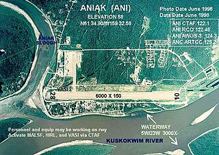
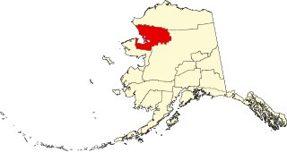
Aniak is a city in the Bethel Census Area in the U.S. state of Alaska. At the 2010 census the population was 501, down from 572 in 2000.

The Kuskokwim River or Kusko River is a river, 702 miles (1,130 km) long, in Southwest Alaska in the United States. It is the ninth largest river in the United States by average discharge volume at its mouth and seventeenth largest by basin drainage area. The Kuskokwim River is the longest river system contained entirely within a single U.S. state.
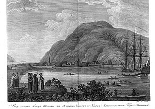
Crow Village is an unincorporated community on the Kuskokwim River in the U.S. state of Alaska. There are an estimated six residents.

Lavrenty Alekseyevich Zagoskin was a Russian naval officer and explorer of Alaska.
Fort Durham, also known as Fort Taku, Taku, Taco, and Tacouw, is an archaeological site near Taku Harbor, Alaska, within the limits of Juneau City and Borough and Tongass National Forest. It was one of three Hudson's Bay Company (HBC) posts set up in Russian America. The Fort Durham Site was declared a U.S. National Historic Landmark in 1978.

This is a list of the National Register of Historic Places listings in Bethel Census Area, Alaska.

This is a list of the National Register of Historic Places listings in Aleutians East Borough, Alaska.

This is a list of the National Register of Historic Places listings in Lake and Peninsula Borough, Alaska, United States.
This is a list of the National Register of Historic Places listings in Northwest Arctic Borough, Alaska.

This is a list of the National Register of Historic Places listings in North Slope Borough, Alaska.
This is a list of the National Register of Historic Places listings in Wrangell–St. Elias National Park and Preserve.
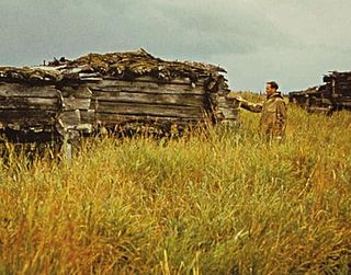
The Old Savonoski Site is the former site of a native village in Lake and Peninsula Borough, Alaska, that was buried by ash in the June 1912 eruption of the Novarupta Volcano. The site is located near the confluence of the Savonoski and Ukak Rivers, and is within the bounds of the Katmai National Park and Preserve. The site was visited by archaeologists in 1953, who identified a number of surviving elements, including fifteen barabaras, or semi-subterranean dwellings.
The Kad'yak, also known as Kadyak and Kadiak, was a wooden-hulled sailing merchant ship belonging to the Russian-American Company. Purchased by the company in 1851, she was used to transport personnel and supplies among its settlements in Russian Alaska, and to transport trade goods to San Francisco. On April 2, 1860, she struck a rock near the port of Kodiak, Alaska while carrying a load of ice and trade goods destined for San Francisco, and sank near Spruce Island after drifting for three days.
The Russian Kiln Site is a historic archaeological site on Long Island, part of the Kodiak Archipelago of southern Alaska. It is one of the oldest industrial sites in Alaska, established by the Russian American Company for the production of bricks, an otherwise rare commodity in 19th-century Russian America. The kilns on the site were reported to produce between 3000 and 6000 bricks annually. Brick debris is scattered along the shore of Long Island in the area, which subsided after the 1964 Alaska earthquake and is subject to erosion. It is one of several sites in the vicinity of Kodiak Island where the Russians produced bricks.
Takli Island is an island off the southern coast of the Alaska Peninsula in the Shelikof Strait of southwestern Alaska. It is located at the mouth of Amalik Bay, off the mainland portion of Kodiak Island Borough, in Katmai National Park and Preserve. The area was first archaeologically investigated in the 1960s, when the prehistory of the area was little known, and the island's sites are type sites for a series of archaeological cultures.
The Moose River Site is a prehistoric archaeological site in Kenai Peninsula Borough, Alaska. Located near the confluence of the Kenai and Moose Rivers near Sterling, it is apparently a camp or village site that was used as a fishing camp about 1500 years ago. The site includes seven house pits and three food cache pits.

St. Michael Redoubt was a fortified trading and supply post established by the Russian-American Company in 1833, at the location of what is now the city of St. Michael, Alaska. It is located on the southern shore of Norton Sound at a convenient location near the mouth of the Yukon River. The fort, established by order of Ferdinand Wrangel, was used in following decades as a logistics point for exploration of southwestern Alaska and the Alaskan interior via the Yukon and other rivers.
The Savonoski River Archeological District encompasses a complex of prehistoric and historic archaeological sites on the Savonoski River near the mouth of the Grosvenor River in Katmai National Park and Preserve, located on the Alaska Peninsula of southwestern Alaska. At least two sites, designated 49-MK-3 and 49-MK-4 by state archaeologists, were identified when the site was listed in 1978. In 2003, the district was enlarge to include a third site, XMK-53. This area is believed to be the site of one of a group of Native Alaskan settlements referred to in Russian records as "Severnovsk". Excavations of a known prehistoric site in 1964 uncovered additional evidence of a post-contact settlement.

This is a list of the National Register of Historic Places listings in Copper River Census Area, Alaska.