
Totem poles are monumental carvings, a type of Northwest Coast art, consisting of poles, posts or pillars, carved with symbols or figures. They are usually made from large trees, mostly western red cedar, by First Nations and indigenous peoples of the Pacific Northwest coast including northern Northwest Coast Haida, Tlingit, and Tsimshian communities in Southeast Alaska and British Columbia, Kwakwaka'wakw and Nuu-chah-nulth communities in southern British Columbia, and the Coast Salish communities in Washington and British Columbia.

Ketchikan is a city in and the borough seat of the Ketchikan Gateway Borough of Alaska. It is the state's southeasternmost major settlement. Downtown Ketchikan is a National Historic District. With a population at the 2010 census of 8,050, it is the fifth-most populous city in the state, and tenth-most populous community when census-designated places are included. The surrounding borough, encompassing suburbs both north and south of the city along the Tongass Highway, plus small rural settlements accessible mostly by water, registered a population of 13,477 in that same census. US Census results put the 2019 population at 13,901 people. Incorporated on August 25, 1900, Ketchikan is the earliest extant incorporated city in Alaska, because consolidation or unification elsewhere in Alaska resulted in the dissolution of those communities' city governments. Ketchikan is located on Revillagigedo Island, so named in 1793 by Captain George Vancouver.

Klawock is a city in Prince of Wales–Hyder Census Area, in the U.S. state of Alaska, on the west coast of Prince of Wales Island, on Klawock Inlet, across from Klawock Island. The population was 755 at the 2010 census, down from 854 in 2000. It is located 90 kilometres (56 mi) from Ketchikan, 11 kilometres (6.8 mi) from Craig, and 39 kilometres (24 mi) from Hollis.

The City and Borough of Wrangell is a borough in Alaska, United States. As of the 2010 census the population was 2,369, up from 2,308 in 2000.

The Tongass National Forest in Southeast Alaska is the largest U.S. National Forest at 16.7 million acres. Most of its area is temperate rain forest and is remote enough to be home to many species of endangered and rare flora and fauna. The Tongass, which is managed by the United States Forest Service, encompasses islands of the Alexander Archipelago, fjords and glaciers, and peaks of the Coast Mountains. An international border with Canada runs along the crest of the Boundary Ranges of the Coast Mountains. The forest is administered from Forest Service offices in Ketchikan. There are local ranger district offices located in Craig, Hoonah, Juneau, Ketchikan, Petersburg, Sitka, Thorne Bay, Wrangell, and Yakutat.
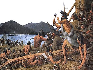
The Battle of Sitka was the last major armed conflict between Russians and Alaska Natives, and was initiated in response to the destruction of a Russian trading post two years before. The primary combatant groups were the Kiks.ádi Clan of Sheetʼká Xʼáatʼi of the Tlingit nation and agents of the Russian-American Company assisted by the Imperial Russian Navy.
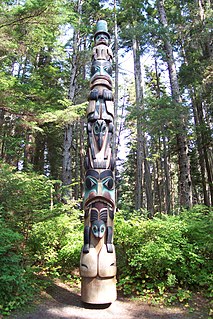
Sitka National Historical Park is a national historical park in Sitka in the U.S. state of Alaska. It was redesignated as a national historical park from its previous status as national monument on October 18, 1972. The park in its various forms has sought to commemorate the Tlingit and Russian experiences in Alaska.
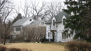
Golden Hill is an affluent and historic neighborhood overlooking the White River on the west side of Indianapolis's Center Township, in Marion County, Indiana. The district is bounded on the east by Clifton Street, which is west of Martin Luther King Jr. Boulevard ; on the west by the White River and the Central Canal; on the south by Thirty-sixth Street; and on the north by Woodstock Country Club, immediately south of Thirty-eighth Street. Golden Hill is noted for its collection of homes designed by several of the city's prominent architects. The estate homes reflect several styles of period revival architecture. The district is known as for its community planning and remains an exclusive enclave for the city's prominent families. Golden Hill was added to the National Register of Historic Places in 1991.

The Alaska Native Brotherhood (ANB) and its counterpart, the Alaska Native Sisterhood (ANS), are two nonprofit organizations founded to address racism against Alaska Native peoples in Alaska. ANB was formed in 1912 and ANS founded three years later. For the first half of the 20th century, they were the only organizations working for the civil rights of Alaska Natives in the territory and state.
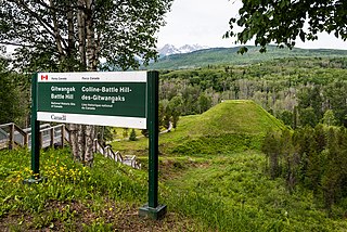
Gitwangak Battle Hill National Historic Site, formerly Kitwanga Fort National Historic Site, is a National Historic Site of Canada located near the village of Kitwanga in the Regional District of Kitimat-Stikine in British Columbia, Canada. It protects Battle Hill, a hillfort built by the Gitwangak people in the mid-17th century. The park was developed by George Macdonald, whose archaeological study was of the site, and who was the Director of the National Museum of Civilization until the opening of its current building.
Cape Fox Village is a locality in Southeast Alaska near present-day Ketchikan. It is the site of a former village called Gaash of the Cape Fox people of the Tlingit. The location of the village is on the east side of Revillagigedo Channel, four miles south of Boca de Quadra. The name was recorded in 1880 by Ivan Petroff during the 10th Census, who reported 100 Tlingit still living there. During the Harriman Expedition of Alaska that took place in 1899 several native artifacts that were important to the neighboring populations of Cape Fox were removed and relocated to several academic institutions across the United States, including the Field Museum in Chicago, and Cornell University. The expedition saw the artifacts as inanimate objects from a deserted village. To the Tlingit living nearby, the artifacts were a sacred part of their identity. This event is referred as the "Looting of Cape Fox." Since the looting, several artifacts have been returned to Tlingit communities near Cape Fox in an effort to return stolen artifacts to the ancestors of who created them.

Fort Tongass was a United States Army base on Tongass Island, in the southernmost Alaska Panhandle, located adjacent to the village of the group of Tlingit people on the east side of the island. Fort Tongass was the first US Army base established in Alaska following its purchase from the Russian Empire in 1867 and was garrisoned by the 2nd U.S. Artillery under the command of Captain Charles H. Peirce. Historian Hubert Howe Bancroft notes: "the site was well chosen, containing a plentiful supply of timber and pasture, while fish and game abound in the neighbourhood.

Totem Bight State Historical Park is a 33-acre (13 ha) state park in the U.S. state of Alaska. It is located north of Ketchikan.

Nathan Jackson is an Alaska Native artist. He is among the most important living Tlingit artists and the most important Alaskan artists. He is best known for his totem poles, but works in a variety of media.

Linn Argyle Forrest, Sr. (1905–1987) was an American architect of Juneau, Alaska who worked to restore "authentic Southeast Alaska Native architecture, especially totem poles". During the 1930s and the Great Depression, he oversaw Civilian Conservation Corps programs of the New Deal to preserve totem poles and other aspects of traditional, native architecture. In conjunction with a $24,000 U.S. grant to the Alaska Native Brotherhood as a CCC project, Forrest oversaw the construction of the Shakes Island Community House and totems at Wrangell, Alaska during 1937-1939. Drawing on this experience, he later wrote The Wolf and the Raven: Totem Poles of Southeastern Alaska, which has been printed in 20 editions.

The Totem Heritage Center is a museum operated by the City of Ketchikan in the U.S. state of Alaska.
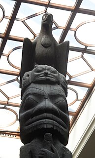
The Nisga'a and Haida Crest Poles of the Royal Ontario Museum are a collection of four large totem poles, hand carved from western red cedar by the Nisga’a people and Haida people of British Columbia's coast. The poles are referred to as: Three Persons Along (Nisga'a); the Pole of Sag̱aw̓een (Nisga'a); the Shaking Pole of Kw’ax̱suu (Nisga'a); and House 16: Strong House Pole (Haida). Each of the crest poles tell a family story, as carved figures represent crests that commemorate family history by describing family origins, achievements and experiences. These memorial poles were typically placed in front of the owners' house along the beach.

The Chief Shakes Historic Site is a historic collection of original and recreated Native Alaskan artifacts. It is located on Shakes Island, inside Wrangell Harbor, Wrangell City and Borough, Alaska. The most prominent feature of the site is a 1940 reconstruction of a Tlingit community house. This structure incorporates six original house posts, carved poles similar to totem poles. The house posts, four of which are from the community house of Chief Shakes, a line of like-named Tlingit clan leaders, are reported to be among the oldest known to survive. The house is surrounded by seven totem poles, two of which are original Tlingit work, and five of which are copies created by crews of the Civilian Conservation Corps that also built the house.

The Chief Kashakes House, also known as the Eagle Tail House and Chief Kah-Shakes House, is a historic Tlingit clan house in Saxman, Alaska. Built in 1895 using balloon framing, the two story wood frame structure was the first structure built in Saxman, and is the only surviving clan house of its type there. It has a hip roof, and is clad in shiplap siding. The front originally had a porch extending across the full width, but this has been reduced to just the central portion. Three totem poles flank the building, two eagle-topped poles to the right and a beaver pole to the left. An old Russian cannon stands near the house.

The Pioneer Square totem pole, also referred to as the Seattle totem pole and historically as the Chief-of-All-Women pole, is a Tlingit totem pole located in Pioneer Square in downtown Seattle, Washington.


