
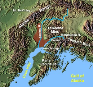
Matanuska-Susitna Borough is a borough located in the U.S. state of Alaska. Its borough seat is Palmer, and the largest community is the census-designated place of Knik-Fairview. As of the 2020 census, the borough's population was 107,801.

Palmer is a city in and the borough seat of the Matanuska-Susitna Borough, Alaska, United States, located 42 miles (68 km) northeast of Anchorage on the Glenn Highway in the Matanuska Valley. It is the ninth-largest city in Alaska, and forms part of the Anchorage Metropolitan Statistical Area. As of the 2020 census, the population of the city is 5,888, down from 5,937 in 2010.
Wasilla (Dena'ina: Benteh) is a city in Matanuska-Susitna Borough, Alaska, United States, and the fourth-largest city in Alaska. It is located on the northern point of Cook Inlet in the Matanuska-Susitna Valley of the southcentral part of the state. The city's population was 9,054 at the 2020 census, up from 7,831 in 2010. Wasilla is the largest city in the borough and a part of the Anchorage metropolitan area, which had an estimated population of 398,328 in 2020.

This is a list of the National Register of Historic Places listings in Matanuska-Susitna Borough, Alaska.

The Alaska State Fair is an annual state fair held in Palmer, Alaska, United States. The fairgrounds are located approximately one hour north of Anchorage and draw visitors from the entire Municipality of Anchorage and beyond for the popular 1½-week event beginning at the end of August. The fair is famous for its record setting giant vegetables and picturesque location at the foot of the Chugach Mountains in the Matanuska-Susitna Valley. The event features amusement rides, food concessions, competitive exhibits, carnival games, live performances and more.
David Williams was an American architect and community planner. He worked in the Washington, D.C. office of Federal Emergency Relief Administration (FERA).
In 1935, the Federal Emergency Relief Administration created an experimental farming community known as the Matanuska Valley Colony as part of the New Deal resettlement plan. Situated in the Matanuska Valley, about 45 miles northeast of Anchorage, Alaska, the colony was settled by 203 families from Minnesota, Wisconsin and Michigan. The colony project cost about $5,000,000 and, after five years, over half of the original colonists had left the valley. By 1965, only 20 of the first families were still farming the valley.
The Curry Lookout, also known as Camp Regalvista, is an historic backcountry shelter in Denali State Park, Alaska. It is located on top of Curry Ridge, overlooking the Susitna River and the hamlet of Curry, a former depot on the Alaska Railroad. The only access to the shelter is via a 3-mile (4.8 km) hiking trail beginning at mile 137.2 of the Parks Highway. The shelter is a hexagonal wood-frame structure with a tent-shaped roof, and no foundation. Each side is about 6.5 feet (2.0 m) wide and 8 feet (2.4 m) high. A flagpole rises from the center of the shelter, and is secured to the structure via steel cables. The shelter was built by the railroad in 1923, the same year the Curry Hotel was built. It was intended as an excursion point for visitors, providing views of the surrounding area, including Denali.

The Fairview Inn is a historic hotel building on Main Street in the center of Talkeetna, Alaska, United States. It is a two-story frame structure, with a hip roof. The main block, 36 feet (11 m) square, was built between 1920 and 1923, following the arrival in the area of the Alaska Railroad. The building exterior is little-altered since then; its major modification has been the addition in the 1970s of an addition for owner living quarters. The interior also still follows essentially the same floor plan as when it was built.
The Herried House, also known as Grow House, is a historic house at 4400 North Palmer-Fishook Road, near Palmer, Alaska. It is a 1+1⁄2-story log structure, built from pre-cut logs that were assembled on site. The walls are three-sided logs, notched at the corners, with the gaps filled by burlap and caulking. To the west side of the main block is a wood-frame garage which has log siding. The house was built in 1935 by the Works Progress Administration as part of the Matanuska Valley Colony, and is one of its best-preserved survivors. The first owners, Leonard and Ellie Herried, lived there 1935–38.

The Hyland Hotel, also briefly known as the Everglenn Hotel, is a historic hotel building located at 333 W Evergreen Avenue in the heart of Palmer, Alaska. The Hyland Hotel is recognized as a building of historical significance by the city of Palmer and was officially listed by the United States Department of the Interior on the National Register of Historic Places on June 21, 1991. This property was built as a direct result of The New Deal Colony Settlement of the Matanuska-Susitna Valley in Alaska, where settlers were brought to the Matanuska-Susitna valley to colonize Alaska from 1935 - 1940. It is a 2+1⁄2-story wood-frame structure with a front-gable roof and a glass-enclosed porch that has been converted to hotel rooms which extend across the front of the building. The original building was constructed in 1935 and measures 30 x 30 feet. A 10 x 14 foot addition was built on the rear of the building in 1953 to add additional living and storage space.

The Knik Site, also known as the Old Knik Townsite, is the location in Matanuska-Susitna Borough, Alaska that was once home to the largest settlement on Cook Inlet. The only surviving remnants of the community are a former log roadhouse, now a museum operated by the Wasilla-Knik Historical Society, and a log cabin. The Knik area had long been a meeting point of Native Alaskans, and in 1898 it became the principal community on Cook Inlet from which goods were shipped into the interior. In 1916 the Alaska Railroad reached the site of present-day Anchorage, bypassing Knik and leading to Anchorage's growth. When the railroad reached Wasilla, Knik lost all importance as a transshipment point, and its buildings were either abandoned or moved to one of the other communities. Knik is located about 13 miles (21 km) southwest of Wasilla.
The Blanche and Oscar Tryck House is a historic house on North Knik Street in Wasilla, Alaska. Built sometime before 1916 at Knik, it was the first house in Wasilla when the community was established, moved there by the Trycks in 1917. It is a single-story wood-frame structure, roughly rectangular in shape, with a concrete foundation and a corrugated metal gable roof configured to capture rainwater for laundry and other uses. It has a brick chimney and a root cellar, and has been vacant since Oscar Tryck died in 1964.
The Sutton Community Hall is a historic municipal building in Sutton, Alaska. It is located on the west side of Jonesville Road, about 0.25 miles (0.40 km) north of its junction with the Glenn Highway. It is a single-story wood-frame structure, measuring 40 by 70 feet, with a shallow-pitch gabled sheet metal roof. The building has entrances on the north, south and east sides, the east-facing one sheltered by a hood with diagonal bracing. The exterior has several types of cladding, including asphalt shingles and board-and-batten siding. The building was built in 1927 to serve as a bunkhouse for workers building the Eklutna Power Plant, and was moved to the present location in 1950 to serve the unincorporated community of Sutton as a meeting space. The hall served the community as its principal civic and social meeting space for forty years.
The Matanuska Colony Community Center, also Palmer Historic District, is a cluster of buildings near the center of Palmer, Alaska that were the centerpiece of the Depression-era Matanuska Valley Colony. This federal rural resettlement program was intended to give needy families resources and land to improve their condition. The colony's buildings were erected beginning in 1935, and those that survive represent a well-preserved example of government community planning. It is centered on a city block bounded by East Dahlia Avenue, South Valley Way, South Denali Street, and East Elmwood Avenue, and extends to the north and south. The buildings on this block are organized around a grassy quadrangle, laid out in 1935. Prominent buildings include the Palmer Depot and three churches, located in the block just southeast of the quadrangle, one of which, the United Protestant Church, is a distinctive log structure. The colony's Central School, now added to several times, houses the offices of the Matanuska-Susitna Borough.
The Palmer Depot is a historic train station at South Valley Way and Evergreen Avenue in Palmer, Alaska. It is a large three-section single story frame structure, built in 1935 to provide transportation services to the newly established Matanuska Valley Colony. The main section is the former warehouse, which is 94 feet (29 m) long. The next section, with a lower profile than the warehouse, housed baggage facilities, a passenger waiting area, and living quarters for the station agent. The third section, the smallest of the three, houses the former ticketing office. The building now houses a community center.
The Patten Colony Farm is a historic farm property in Palmer, Alaska. It is located near milepost 39.9 on the Glenn Highway, and is a relatively complete instance of a farmstead established in the 1930s as part of the Matanuska Valley Colony initiative. The complex consists of eight buildings, six of which were built in the 1930s. The main house is an L-shaped log structure with a concrete foundation, a rarity in the colony. Smaller outbuildings include a log outhouse, a chicken house, and two barns, one of which is the only surviving horse barn of the colony.

The Raymond Rebarchek Colony Farm is a historic farm property on Rebarchek Avenue in Palmer, Alaska. It consists of a 40-acre (16 ha) tract of land granted to Raymond Rebarchek in a 1935 land lottery organized by the Matanuska Valley Colony, a Depression-era agricultural colony project. The property was listed on the National Register of Historic Places in 1978. At that time, the farm complex included ten buildings, including Rebarcheck's original log house, a dairy barn, a well house, a greenhouse, and a chicken house. Only the original farmhouse, silo, and milking parlor are still standing today. The Alaska State Fair purchased the property in 2002 and is contemplating the establishment of a demonstration farm there.

The Puhl House, also known as the Bacon House, is a historic house at the corner of Scott Road and Glenn Highway in Palmer, Alaska. It is a rectangular single-story log structure measuring 35 by 25 feet, built out of round logs joined by saddle notches at the corners. The diameter and length of the logs reduces as they rise to the eaves; oakum chinking is used to close the gaps. The house was built in 1935 by Joe and Blanche Puhl, settlers who were part of the Matanuska Valley Colony settlement project. This building is distinctive as a colony house because it was not built by the crews of the Works Progress Administration that built most of the colony's housing; the Puhls organized their own construction team and acquired materials for its construction on their own.
The Old Willow Community Center is a historic community building on West Willow Community Center Circle, off mile marker 69.7 of the Parks Highway in Willow, Alaska. It is a single-story log structure, measuring 60 by 40 feet, built out of local spruce. It is covered by a broad aluminum gabled roof; the gable ends are finished in wooden shingles. The interior consists of a single large chamber. The building was constructed in 1961 as part of a community drive for a meeting space that was more spacious than the local railroad station. In 1992, it was moved a short way south of its original location, where the new community center and library now stand. The building continues to be used for community events.


