
Eagle is a village on the south bank of the Yukon River near the Canada–US border in the Southeast Fairbanks Census Area, Alaska, United States. It includes the Eagle Historic District, a U.S. National Historic Landmark. The population was 86 at the 2010 census. Every February, Eagle hosts a checkpoint for the long-distance Yukon Quest sled dog race.

Chisana is a census-designated place (CDP) in the Copper River Census Area in the U.S. state of Alaska. As of the 2010 Census, the population of the CDP was 0. The English name Chisana derives from the Ahtna Athabascan name Tsetsaan' Na, meaning literally 'copper river'. The Chisana River joins the Nabesna River just north of Northway Junction, Alaska, to form the Tanana River, a major tributary of the Yukon River. The Chisana Airport consists of a turf and gravel runway which is largely serviced by flights from Tok, Alaska.

The Fortymile River is a 60-mile (97 km) tributary of the Yukon River in the U.S. state of Alaska and the Canadian territory of Yukon. Beginning at the confluence of its north and south forks in the Southeast Fairbanks Census Area, the Fortymile flows generally northeast into Canada to meet the larger river 32 miles (51 km) southeast of Eagle, Alaska.
This is a list of properties and districts listed on the National Register of Historic Places in Alaska. There are approximately 400 listed sites in Alaska. Each of the state's 30 boroughs and census areas has at least two listings on the National Register, except for the Kusilvak Census Area, which has none.

The Brooks River Archaeological District encompasses a large complex of archaeological sites along the banks of the Brooks River in Katmai National Park and Preserve in the U.S. state of Alaska. It includes at least twenty separate settlement sites with documented occupation dates from 2500 BCE to recent (post-contact) history. It was declared a National Historic Landmark in 1993. The site is partly occupied by the Brooks Camp, one of the major visitor areas of the park.

Cape Nome Mining District Discovery Sites is a National Historic Landmark located in Nome, Alaska. It was named a National Historic Landmark in 1978. It is significant for its role in the history of gold mining in Alaska, in particular the Nome Gold Rush that began in 1899.

The Skagway Historic District and White Pass is a National Historic Landmark District encompassing a significant portion of the area within the United States associated with the Klondike Gold Rush. It includes the historic portion of Skagway, Alaska, including the entire road grid of the 1897 town, as well as the entire valley on the United States side of White Pass all the way to the Canada–US border. This area includes surviving fragments of three historic routes used during the Gold Rush, as well as the route of the White Pass and Yukon Railroad. Almost 100 buildings remain from the Gold Rush period. Portions of the district are preserved as part of Klondike Gold Rush National Historical Park.
Nabesna is a census-designated place and unincorporated community in northern Copper River Census Area, Alaska, United States, in the northern part of the Wrangell-St. Elias National Park and Preserve. It lies along the Nabesna Road, a gravel road that connects it to the Tok Cut-Off at Slana. Its elevation is 2,979 feet (908 m). Founded by and named for the Nabesna Mining Company, the community received a post office in 1909. Located at the base of White Mountain in the Wrangell Mountains, it lies west of the Nabesna River. According to the 2020 census, there were two people residing at this location.

The Bremner Historic Mining District is a historic district in Wrangell-St. Elias National Park and Preserve in Alaska. It is named after John Bremner, who in 1884-1885 was the first non-native person to live in the area and who prospected for gold along the Bremner River. Located just to the north of the Bremner River, it was the scene of an important placer gold discovery in 1902, and played a key role in the history of the Copper River Basin. Only a few miners struck it rich, but the resulting demand for materials and supplies helped establish regional transportation networks, encouraged supporting industries, and hastened the exploration and settlement of the entire region. While small-scale placer mining continued for over forty years, lode development was largely confined to the period between 1934 and 1941, the district's most significant era.

The Coal Creek Historic Mining District is a gold-mining area in the Yukon-Charley Rivers National Preserve of Alaska dating from the 1930s. It features a gold dredge and a supporting community of several dozen buildings, established by mining entrepreneur Ernest Patty.

This is a list of the National Register of Historic Places listings in Bethel Census Area, Alaska.
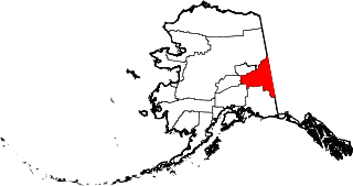
This is a list of the National Register of Historic Places listings in Southeast Fairbanks Census Area, Alaska.

Biederman's Cabin, also called Biederman's Fish Camp, is a privately owned cabin on the Yukon River in Alaska. Located within the Yukon-Charley Rivers National Preserve, it is maintained as a historic site representing the subsistence lifestyle employed by Interior Alaska residents during the early years of the 20th century and is one of the few structures within the preserve.

The George McGregor Cabin on the Yukon River, about two miles downstream from Coal Creek, in the Yukon-Charley Rivers National Preserve of Alaska is a historic Log cabin built in 1938 that was listed on the U.S. National Register of Historic Places in 1987.

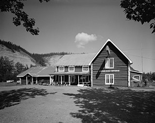
The Slana Roadhouse, on Nabesna Road in Slana, Alaska, in the Valdez-Cordova Census Area, is a historic site dating to 1928. The site was listed on the National Register of Historic Places in 2005. The listing included four contributing buildings on 5 acres (2.0 ha).
The Nome–Council Highway is a highway that runs for 71.970 miles (115.824 km) between the communities of Council and Nome in the Nome Census Area of the Unorganized Borough in the U.S. state of Alaska. The road travels east from Nome, following the shore of the Bering Sea until it reaches the ghost town of Solomon. From there, the route travels northeast through the interior of the Seward Peninsula before it terminates on the south bank of the Niukluk River, south of Council. One of three highways traveling from Nome to surrounding communities, the highway is disconnected from the rest of the Alaska Highway System. The route is unpaved for its entire length and becomes impassable for automobiles in the winter outside of a short portion immediately outside of Nome. The portion of the road between Nome and Solomon is part of the Iditarod Trail and the highway passes several historic sites associated with the trail and the area's gold mining history.

The Juneau Downtown Historic District encompasses the historic commercial heart of the city of Juneau, Alaska. It extends along South Franklin Street, from the cruise terminal in the south to Second Street in the north, and westward along Second and Front Streets to Main Street. This area was the center of Juneau's economic activity from its founding in 1880 as a gold mining camp, through its growth into an urbanized area in the early 20th century, including its eventual designation as the territorial capital in 1906. In the early days of the gold mining camp business was centered in the area bounded by Front, Main and South Franklin, with maritime activities in particular eventually extending further south along the shore of the Gastineau Channel by making land using mine tailings. The early buildings have relatively utilitarian architecture, while those of the early 20th century are somewhat more ornate, with Late Victorian details. Notable buildings from this period include the Alaska Steam Laundry and the Valentine Building.
The Gakona Roadhouse is a historic traveler service facility in Gakona, Alaska, at mile 205 of the Glenn Highway. It is a 1-1/2 log structure with a gabled roof covered in corrugated metal. A shed-roof addition extends to the main block's east side. The roadhouse was built c. 1904, during the construction by the United States Army of the Trans-Alaska Military Road between Valdez and Eagle. This roadhouse was strategically located at a place where that road diverged from the old Eagle Trail, used by miners to reach the gold rush fields of the Yukon River. The original 1904 structure is used for storage; the present roadhouse facilities are provided by later (1920s) structures.
The Fairbanks Exploration Company Gold Dredge No. 5 was a historic gold mining dredge in a remote area of Fairbanks North Star Borough, Alaska, north of the city of Fairbanks. It was last located on Upper Dome Creek, shortly northeast of the mouth of Seattle Creek, about 20 miles (32 km) north of Fairbanks, prior to its being scrapped c. 2012. The dredge was manufactured by the Bethlehem Steel Company in 1928, shipped in pieces to Alaska, and assembled by the Fairbanks Exploration Company on Cleary Creek, where it was used until 1942. It thereafter served on Eldorado Creek (1947–55) and Dome Creek (1955-59) before it was abandoned.

This is a list of the National Register of Historic Places listings in Copper River Census Area, Alaska.


