Related Research Articles

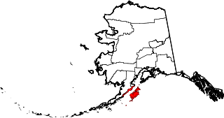
Kodiak Island, is a large island on the south coast of the U.S. state of Alaska, separated from the Alaska mainland by the Shelikof Strait. The largest island in the Kodiak Archipelago, Kodiak Island is the second largest island in the United States and the 80th largest island in the world, with an area of 3,595.09 sq mi (9,311.2 km2), slightly larger than Cyprus. It is 160 km long and in width ranges from 16 to 97 kilometers. Kodiak Island is the namesake for Kodiak Seamount, which lies off the coast at the Aleutian Trench. The largest community on the island is the city of Kodiak, Alaska.

The Amalik Bay Archeological District is a geographic area with a significant number of archaeological sites in Alaska. It is located on the Pacific coast of Katmai National Park and Preserve, in the mainland portion of Kodiak Island Borough, Alaska.
Fort Durham, also known as Fort Taku, Taku, Taco, and Tacouw, is an archaeological site near Taku Harbor, Alaska, within the limits of Juneau City and Borough and Tongass National Forest. It was one of three Hudson's Bay Company (HBC) posts set up in Russian America. The Fort Durham Site was declared a U.S. National Historic Landmark in 1978.

Fort Abercrombie State Historical Park, also known as the Fort Abercrombie State Historic Site, is an Alaska state park on Kodiak Island, Alaska. It includes 182 acres (74 ha) of land at the end of Miller Point, located on the eastern shore of Kodiak Island northeast of the city of Kodiak. The park, established in 1969, is noted for its historical World War II fortifications and its scenery, which includes bluffs overlooking the ocean, spruce forests, and meadows. The site was named in honor of the early Alaska explorer and United States Army officer Lt. Col. William R. Abercrombie. The fortifications, whose surviving elements include gun emplacements, underground magazines, and foundational remnants of buildings, were built in 1941 and abandoned after the war ended, having seen no action.

Yukon Island is an island in outer Kachemak Bay, an inlet of the Cook Inlet of south central Alaska. The island is located about 9 miles (14 km) south of Homer. The island is archaeologically sensitive, with a number of sites documenting the prehistory of the bay. The Yukon Island Main Site, a National Historic Landmark, is a major shell midden site at which the pioneering archaeologist Frederica de Laguna was able to sequence 1500 years of the area's prehistory, and other sites have been found on the island since then. The island is now home to an educational retreat center.

Woody Island is located in Chiniak Bay, 2.6 miles (4.2 km) east of Kodiak, Alaska. It was originally settled by the native Alutiiq people who called themselves Tangirnarmiut, "the people of Tangirnaq." They inhabited and used Woody Island for thousands of years. The Russians established an agricultural colony on Woody Island in 1792. It was officially designated Wood Island in 1894 by the US Post Office and was the primary coastal settlement for commerce and trade for many years. The first road in Alaska was built on Woody Island. Aside from the Aleut presence, the island has gone through four periods of occupation by non-natives, and is largely unoccupied today. The island is approximately 2.8 miles long from north to south and 1.8 miles wide and 13 miles in circumference.
This is a list of the National Register of Historic Places listings in Kodiak Island Borough, Alaska.
The Port Moller Hot Springs Village Site is a prehistoric archeological site on the Alaska Peninsula. It is located on the shores of Moller Bay, an indentation on the peninsula with extensive tidal flats. Until historical times the area was a border region between the Aleut and the Inuit. The site is notable for the presence of a sulphurous hot spring, which provides drinkable water. The 50-acre (20 ha) site contains the remains of a native village and extensive refuse middens. The site was first excavated in 1928.
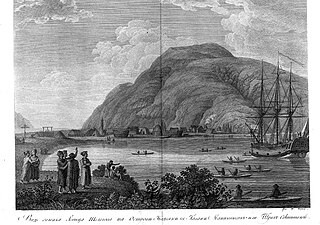
The Kad'yak, also known as Kadyak and Kadiak, was a wooden-hulled sailing merchant ship belonging to the Russian-American Company. Purchased by the company in 1851, she was used to transport personnel and supplies among its settlements in Russian Alaska, and to transport trade goods to San Francisco. On April 2, 1860, she struck a rock near the port of Kodiak, Alaska while carrying a load of ice and trade goods destined for San Francisco, and sank near Spruce Island after drifting for three days.
Chugachik Island is a small island in the upper reaches of Kachemak Bay, an indent in the Kenai Peninsula of south-central Alaska. The island falls within the bounds of Kachemak Bay State Park.
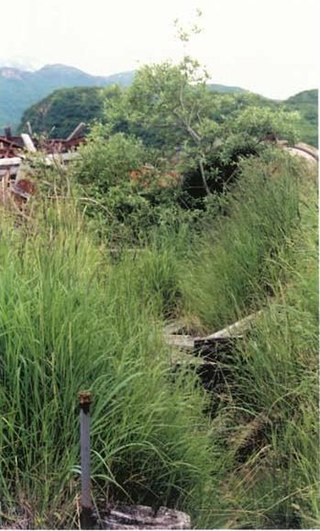
The Russian Kiln Site is a historic archaeological site on Long Island, part of the Kodiak Archipelago of southern Alaska. It is one of the oldest industrial sites in Alaska, established by the Russian American Company for the production of bricks, an otherwise rare commodity in 19th-century Russian America. The kilns on the site were reported to produce between 3000 and 6000 bricks annually. Brick debris is scattered along the shore of Long Island in the area, which subsided after the 1964 Alaska earthquake and is subject to erosion. It is one of several sites in the vicinity of Kodiak Island where the Russians produced bricks.
The Kukak Bay Cannery was a commercial razor clam canning operation on the southern coast of the Alaska Peninsula. The cannery operated intermittently from 1922 to 1951, with its most active years before 1936, when most of its complex was destroyed by fire.
The Kaguyak Village Site, designated 49 Afg 4, is a historic and prehistoric archaeological site on the Pacific coast of the Alaska Peninsula in Katmai National Park and Preserve. It is the site of an Alaska Native village which was abandoned after the eruption of Novarupta in 1912. The historic elements of the site include the remains of a Russian Orthodox church and cemetery, as well as a number of frame house remnants and foundations.
Takli Island is an island off the southern coast of the Alaska Peninsula in the Shelikof Strait of southwestern Alaska. It is located at the mouth of Amalik Bay, off the mainland portion of Kodiak Island Borough, in Katmai National Park and Preserve. The area was first archaeologically investigated in the 1960s, when the prehistory of the area was little known, and the island's sites are type sites for a series of archaeological cultures.

The Kukak Village Site is a prehistoric and historic archaeological site, located on the shore of Kukak Bay, on the south coast of the Alaska Peninsula in Katmai National Park and Preserve. The area was documented to be occupied in the early 20th century, and was abandoned after the 1912 volcanic eruption of Novarupta. The Kukak Bay area is also of prehistoric significance, with researchers identifying 89 depressions as likely sites of subterranean houses, and a refuse midden.
KOD-171 is a prehistoric and historic archaeological site in the vicinity of Larsen Bay, a city on the north side of Kodiak Island in southern Alaska. The site was discovered by Smithsonian Institution archaeologist Aleš Hrdlička and described in 1944 as containing both historical Russian artifacts as well as prehistoric Kachemak Bay tradition artifacts. A 1978 survey team reported the site to include 22 house pits and an eroding shell midden. The site, listed on the National Register of Historic Places in 1981, is subject to erosion and vandalism by pot hunters.

St. Michael Redoubt was a fortified trading and supply post established by the Russian-American Company in 1833, at the location of what is now the city of St. Michael, Alaska. It is located on the southern shore of Norton Sound at a convenient location near the mouth of the Yukon River. The fort, established by order of Ferdinand Wrangel, was used in following decades as a logistics point for exploration of southwestern Alaska and the Alaskan interior via the Yukon and other rivers.
Magnetic Island is a small island on the north side of Tuxedni Bay, an inlet on the lower west side of Cook Inlet in south-central Alaska. The island is surrounded by mudflats that are under water during high tides. The island got its name from the presence of magnetism identified during a geological survey in 1951. Its shape and geology are heavily influenced by Mount Redoubt and Mount Iliamna, two active volcanoes located less than 20 miles (32 km) away.
References
- ↑ Federal and state laws and practices restrict general public access to information regarding the specific location of this resource. In some cases, this is to protect archeological sites from vandalism, while in other cases it is restricted at the request of the owner. See: Knoerl, John; Miller, Diane; Shrimpton, Rebecca H. (1990), Guidelines for Restricting Information about Historic and Prehistoric Resources, National Register Bulletin, National Park Service, U.S. Department of the Interior, OCLC 20706997 .
- 1 2 "National Register Information System". National Register of Historic Places . National Park Service. July 9, 2010.
- ↑ "Investigating Brickmaking in Russian America" (PDF). Heritage: Monthly Newsletter of the Alaska Office of History and Archaeology (4). January 1983. Retrieved January 20, 2015.
Boroughs |  | ||
Census areas | |||
There are no sites listed on the National Register of Historic Places in Kusilvak Census Area. | |||
| Topics | |
|---|---|
| Lists by state |
|
| Lists by insular areas | |
| Lists by associated state | |
| Other areas | |
| Related | |
| | This article about a property in Alaska on the National Register of Historic Places is a stub. You can help Wikipedia by expanding it. |