
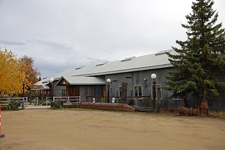
Ester is a census-designated place (CDP) in Fairbanks North Star Borough, Alaska, United States. It is part of the Fairbanks, Alaska Metropolitan Statistical Area. The population in the CDP was 2,422 at the 2010 census, although there are only about a dozen homes in the village itself. The Ester Camp Historic District is a historic district listed on the National Register of Historic Places. Ester was founded as a gold mining camp in the early 1900s, and the economy has focused on mining and services for miners. The Ester Community Association was founded in 1941, and continues to work for the welfare of the community, e.g. establishing and maintaining the Ester Community Park and sponsoring an annual Fourth of July parade. There are several small businesses in Ester, including two saloons, a publishing house, a jewelry maker, hand crafted soap maker, and local artisans. The Ester Volunteer Fire Department, John Trigg Ester Library, Ester Historic Society, and Ester Post Office serve residents in Ester and surrounding areas. There is also a convenience store and secular chapel on the outskirts of the village. Many artists, writers, and musicians reside in Ester, and the local art and music scene has thrived for many years.

'Chisana is a ghost town abandoned and a census-designated place (CDP) in the Valdez-Cordova Census Area in the U.S. state of Alaska. As of the 2010 Census, the population of the CDP was 0. The English name Chisana derives from the Ahtna Athabascan name Tsetsaan' Na', meaning literally 'copper river'. The Chisana River joins the Nabesna River just north of Northway Junction, Alaska, to form the Tanana River, a major tributary of the Yukon River. The Chisana Airport consists of a turf and gravel runway which is largely serviced by flights from Tok, Alaska.
This is a list of properties and districts listed on the National Register of Historic Places in Alaska. There are approximately 400 listed sites in Alaska. Each of the state's 28 boroughs and census areas has at least two listings on the National Register, except for the Kusilvak Census Area, which has none.

The F.E. Company Dredge No. 4, also known as the Pedro Dredge and the Chicken Dredge, was originally owned by the Fairbanks Exploration Company, a subsidiary of the United States Smelting Refining & Mining Co. (USSR&M). It was built by the Yuba Manufacturing Company in California, and was shipped to Pedro Creek north of Fairbanks, Alaska in 1938. It was assembled there, and operated until 1958.

Cape Nome Mining District Discovery Sites is a National Historic Landmark located in Nome, Alaska. It was named a National Historic Landmark in 1978. It is significant for its role in the history of gold mining in Alaska, in particular the Nome Gold Rush that began in 1899.

Gold mining in Alaska, a state of the United States, has been a major industry and impetus for exploration and settlement since a few years after the United States acquired the territory from Russia. Russian explorers discovered placer gold in the Kenai River in 1848, but no gold was produced. Gold mining started in 1870 from placers southeast of Juneau, Alaska.

The Fairbanks mining district is a gold-mining area in the U.S. state of Alaska. Placer mining began near Fairbanks in July 1902, after Felix Pedro, an Italian immigrant and Tom Gilmore discovered gold in the hills north of the Tanana and Chena Rivers in 1901. Pedro died exactly eight years after finding the richest gold placer he would ever know. By 1903 a new rush started, and prospectors staked thousands of claims. However, mining results were disappointing during the summer of 1903, with little gold recovered. Then Dennis O'Shea struck it rich on Fairbanks Creek, No. 8 Above. This was one of the richest claims in the Fairbanks Mining District and paid as high as $136 to the pan. Discoveries on Cleary and Ester Creeks followed, and almost two-thirds of the gold mined in the Tanana hills before 1910 came from these three creeks. Total production of gold was more than $ 30 million. Towns grew on every creek with a combined population of 1,600 residents.
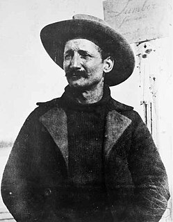
Felice Pedroni, known best to Americans by his Hispanicized alias Felix Pedro, was an Italian immigrant whose discovery of gold in Interior Alaska marked the beginning of the 1902 Fairbanks Gold Rush.

The Coal Creek Historic Mining District is a gold-mining area in the Yukon-Charley Rivers National Preserve of Alaska dating from the 1930s. It features a gold dredge and a supporting community of several dozen buildings, established by mining entrepreneur Ernest Patty.

Goldstream Dredge No. 8 is a ladder dredge operated by the Fairbanks Exploration Company from 1928 to 1959. It is located on the old Steese Highway between Fairbanks and Fox in the central part of Alaska.

Bonanza Creek is a watercourse in Yukon Territory, Canada. It runs for about 20 miles (32 km) from King Solomon's Dome to the Klondike River. In the last years of the 19th century and the early 20th century, Bonanza Creek was the centre of the Klondike Gold Rush, which attracted tens of thousands of prospectors to the creek and the area surrounding it. Prior to 1896 the creek was known as Rabbit Creek. Its name was changed by miners in honour of the millions of dollars in gold found in and around the creek.
The Nome Gold Rush was a gold rush in Nome, Alaska, approximately 1899–1909. It is separated from other gold rushes by the ease with which gold could be obtained. Much of the gold was lying in the beach sand of the landing place and could be recovered without any need for a claim. Nome was a sea port without a harbor, and the biggest town in Alaska.

The Chicken Historic District encompasses part of the historic mining district of Chicken, Alaska. It is located at milepost 66.5 on the north side of the Taylor Highway, and includes fifteen buildings built between 1908 and 1967. Most of these are single-story wood frame structures, with either metal or board-and-batten siding, although there are also some log structures. Many of these buildings were erected by the Fairbanks Exploration Company, which ran the gold mining operations in the area. Notable buildings include the bunkhouse, a gabled log structure, and the Chicken Creek Roadhouse, built in 1906, which was originally two stories in height but was reduced to a single story in 1924. The district also includes a section of water pipeline built by the company to bring water to the area from Mosquito Creek, a distance of about 1 mile (1.6 km). The camp was used until the company ended mining operations in 1967.

The Independence Mines, now Independence Mine State Historic Park, is the site of a former gold mining operation in the Talkeetna Mountains, across Hatcher Pass from Palmer, Alaska. The area's mining history dates to at least 1897, when active claims were reported in the vicinity of Fishook Creek. These early mining efforts were eventually joined to form the Wasilla Mining Company, which worked the mines from 1934 to 1943, and again from 1948 to 1950. The mining operation at Independence was the second-largest hard-rock gold mining operation in the state, after a larger site near Juneau. The company and the miners that preceded it built a substantial mining camp, with as many as sixteen wood frame buildings, which were originally connected to each other by sheltered wooden "tunnels". When the company ended operations in 1950, it had expected to eventually resume operations, but never did; this resulted in a particularly well-preserved collection of mining equipment and buildings, although the weather has since taken a significant toll on the latter.

The Chatanika Gold Camp is a historic gold mining camp at Mile 27¾ of the Steese Highway in Chatanika, Alaska. The camp is set on about 49 acres (20 ha) overlooking Cleary Creek, and consists of thirteen buildings as well as a scattering of old mining tools and equipment. The largest of the buildings are two bunkhouses, finished in corrugated metal. The camp was built in 1925 by the Fairbanks Exploration Company (FEC), which also dug the nearby Davidson Ditch to supply water for the operation of the gold dredges. The Chatanika Camp was the largest of the FEC's mining camps in the Fairbanks area. Five of the surviving buildings date to the initial construction period.
The Chena Pump House, also known just as the Pump House Restaurant, is a restaurant at 796 Chena Pump Road in Fairbanks, Alaska. The restaurant is located in the shell of a 1933 pumping station established by the Fairbanks Exploration Company, Alaska's largest gold mining operator at the time. The pump house was used to provide water to dredges operating on Cripple Creek in the Ester area. The building was abandoned by the company in 1958, and was enlarged and converted into a restaurant in 1978. It was listed on the National Register of Historic Places in 1982.
The Fairbanks Exploration Company Dredge No. 2 is a historic gold mining dredge in a remote area of Fairbanks North Star Borough, Alaska, northeast of the city of Fairbanks. It is currently located on the north bank of Fish Creek, shortly northeast of the mouth of Slippery Creek. Its main structure is a compartmented steel hull, 128 feet (39 m) long, 60 feet (18 m) wide, and 12 feet (3.7 m) high, with a 1-2 story superstructure above made of steel and wood framing sheathed in corrugated metal. It has three gantries, and a digging ladder 112 feet (34 m) long at its bow that weights 178,000 pounds (81,000 kg). All of its original operating equipment was reported to be in place in 1999. The dredge was built in 1927 by the Bethlehem Steel Company, and assembled for use in Alaska in 1928. It was operated by the Fairbanks Exploration Company in the Goldstream Valley from 1928 to 1949, and on Fairbanks Creek and lower Fish Creek from 1950 to 1961.
The Fairbanks Exploration Company Gold Dredge No. 5 was a historic gold mining dredge in a remote area of Fairbanks North Star Borough, Alaska, north of the city of Fairbanks. It was last located on Upper Dome Creek, shortly northeast of the mouth of Seattle Creek, about 20 miles (32 km) north of Fairbanks, prior to its being scrapped c. 2012. The dredge was manufactured by the Bethlehem Steel Company in 1928, shipped in pieces to Alaska, and assembled by the Fairbanks Exploration Company on Cleary Creek, where it was used until 1942. It thereafter served on Eldorado Creek (1947–55) and Dome Creek (1955-59) before it was abandoned.

Anvil Creek is a stream in Alaska. Part of it is in the Nome mining district near Nome, Alaska and became a center of gold rush attention after three Swedes found gold along it. The resulting influx of prospectors brought thousands of people to Nome in the spring of 1899.


