Related Research Articles

The Brooks River Archaeological District encompasses a large complex of archaeological sites along the banks of the Brooks River in Katmai National Park and Preserve in the U.S. state of Alaska. It includes at least twenty separate settlement sites with documented occupation dates from 2500 BCE to recent (post-contact) history. It was declared a National Historic Landmark in 1993. The site is partly occupied by the Brooks Camp, one of the major visitor areas of the park.

This is a list of the National Register of Historic Places listings in Kenai Peninsula Borough, Alaska.

This is a list of the National Register of Historic Places listings in Lake and Peninsula Borough, Alaska, United States.

This is a list of the National Register of Historic Places listings in Matanuska-Susitna Borough, Alaska.

The Tangle Lakes are a 16-mile (26 km) long chain of lakes connected by streams in interior Alaska. They form the headwaters for the Delta River.

Kijik (Dena'ina: Qizhjeh) is a ghost town in Lake and Peninsula Borough, Alaska, United States. An Athabascan village that was established on the shores of Lake Clark in the Alaska Range, its population was recorded at 91 in the 1880 United States Census and declined thereafter, falling to approximately 25 individuals by 1904. Today, the village has been abandoned. The ghost town is located within the bounds of Lake Clark National Park and Preserve.
This is a list of the National Register of Historic Places listings in Lake Clark National Park and Preserve.
This is a list of the National Register of Historic Places listings in Katmai National Park and Preserve.

The DIL-161 Site is a prehistoric archeological site in Katmai National Park and Preserve. Located on the banks of the Alagnak River, the site was first identified in 1997 by National Park Service personnel, and its extents were mapped in 2004. The site is that of a village that was occupied between about 300 BCE and 800 CE. More than 40 cabin sites, which are little more than house pits, have been identified.
The Port Moller Hot Springs Village Site is a prehistoric archaeological site on the Alaska Peninsula. It is located on the shores of Moller Bay, an indentation on the peninsula with extensive tidal flats. Until historical times the area was a border region between the Aleut and the Inuit. The site is notable for the presence of a sulphurous hot spring, which provides drinkable water. The 50-acre (20 ha) site contains the remains of a native village and extensive refuse middens. The site was first excavated in 1928.
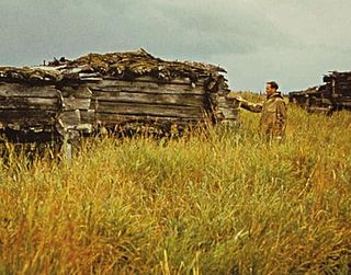
The Old Savonoski Site is the former site of a native village in Lake and Peninsula Borough, Alaska, that was buried by ash in the June 1912 eruption of the Novarupta Volcano. The site is located near the confluence of the Savonoski and Ukak Rivers, and is within the bounds of the Katmai National Park and Preserve. The site was visited by archaeologists in 1953, who identified a number of surviving elements, including fifteen barabaras, or semi-subterranean dwellings.
The Indian Valley Mine is a historic quartz mine located at 27301 Seward Highway near the community of Indian in the Municipality of Anchorage, Alaska, between the main area of Anchorage and the city of Seward on the north shore of Turnagain Arm.
The Kaguyak Village Site, designated 49 Afg 4, is a historic and prehistoric archaeological site on the Pacific coast of the Alaska Peninsula in Katmai National Park and Preserve. It is the site of an Alaska Native village which was abandoned after the eruption of Novarupta in 1912. The historic elements of the site include the remains of a Russian Orthodox church and cemetery, as well as a number of frame house remnants and foundations.
Takli Island is an island off the southern coast of the Alaska Peninsula in the Shelikof Strait of southwestern Alaska. It is located at the mouth of Amalik Bay, off the mainland portion of Kodiak Island Borough, in Katmai National Park and Preserve. The area was first archaeologically investigated in the 1960s, when the prehistory of the area was little known, and the island's sites are type sites for a series of archaeological cultures.

The Kukak Village Site is a prehistoric and historic archaeological site, located on the shore of Kukak Bay, on the south coast of the Alaska Peninsula in Katmai National Park and Preserve. The area was documented to be occupied in the early 20th century, and was abandoned after the 1912 volcanic eruption of Novarupta. The Kukak Bay area is also of prehistoric significance, with researchers identifying 89 depressions as likely sites of subterranean houses, and a refuse midden.
The Fairhaven Ditch is a historic canal on the Seward Peninsula of northwestern Alaska. Located in the Bering Land Bridge National Preserve, it is a 38-mile (61 km) ditch dug in 1906-07 without the benefit of heavy equipment in extremely hostile terrain. The ditch was dug by miners engaged in placer mining on the peninsula, and was used to transport water from Imuruk Lake, the largest body of fresh water on the peninsula, to mining areas north of the lake. It is one of a large number of such canals dug on the peninsula, and was one of the longest. At the bottom it was 11 feet (3.4 m) wide, and was hacked out of permafrost, a volcanic field surrounding the lake, and dirt. Cabins built to house workers and monitor water flow survive. The ditch was listed on the National Register of Historic Places in 1987.
The Moose River Site is a prehistoric archaeological site in Kenai Peninsula Borough, Alaska. Located near the confluence of the Kenai and Moose Rivers near Sterling, it is apparently a camp or village site that was used as a fishing camp about 1500 years ago. The site includes seven house pits and three food cache pits.

St. Michael Redoubt was a fortified trading and supply post established by the Russian-American Company in 1833, at the location of what is now the city of St. Michael, Alaska. It is located on the southern shore of Norton Sound at a convenient location near the mouth of the Yukon River. The fort, established by order of Ferdinand Wrangel, was used in following decades as a logistics point for exploration of southwestern Alaska and the Alaskan interior via the Yukon and other rivers.
The Savonoski River Archeological District encompasses a complex of prehistoric and historic archaeological sites on the Savonoski River near the mouth of the Grosvenor River in Katmai National Park and Preserve, located on the Alaska Peninsula of southwestern Alaska. At least two sites, designated 49-MK-3 and 49-MK-4 by state archaeologists, were identified when the site was listed in 1978. In 2003, the district was enlarge to include a third site, XMK-53. This area is believed to be the site of one of a group of Native Alaskan settlements referred to in Russian records as "Severnovsk". Excavations of a known prehistoric site in 1964 uncovered additional evidence of a post-contact settlement.
References
- ↑ Federal and state laws and practices restrict general public access to information regarding the specific location of this resource. In some cases, this is to protect archeological sites from vandalism, while in other cases it is restricted at the request of the owner. See: Knoerl, John; Miller, Diane; Shrimpton, Rebecca H. (1990), Guidelines for Restricting Information about Historic and Prehistoric Resources, National Register Bulletin, National Park Service, U.S. Department of the Interior, OCLC 20706997 .
- 1 2 "National Register Information System". National Register of Historic Places . National Park Service. July 9, 2010.
- ↑ Mineral Resources of Alaska: Bulletin, Issue 442. Washington, DC: United States Geological Survey. 1910. pp. 198–99.
- ↑ Proposed Lake Clark National Park, Alaska: final environmental statement. Washington, DC: United States Department of the Interior. 1974.
Boroughs |  | ||
Census areas | |||
There are no sites listed on the National Register of Historic Places in Kusilvak Census Area. | |||
| Topics | |
|---|---|
| Lists by state |
|
| Lists by insular areas | |
| Lists by associated state | |
| Other areas | |
| Related | |
| | This article about a property in Alaska on the National Register of Historic Places is a stub. You can help Wikipedia by expanding it. |
| | This article about a location in the Lake and Peninsula Borough, Alaska is a stub. You can help Wikipedia by expanding it. |
| | This article about mining is a stub. You can help Wikipedia by expanding it. |