Big Delta is a census-designated place (CDP) in Southeast Fairbanks Census Area, Alaska, United States. The population was 591 at the 2010 census, down from 749 in 2000. Big Delta is at the confluence of the Delta River and the Tanana River and gets its name from the huge river delta formed by the confluence.

Delta Junction is a city in the Southeast Fairbanks Census Area, Alaska, United States. As of the 2010 census, the population was 958, up from 840 in 2000. The 2018 estimate was down to 931. The city is located a short distance south of the confluence of the Delta River with the Tanana River, which is at Big Delta. It is about 160 km (99 mi) south of Fairbanks. Native inhabitants are Tanana Athabaskans.
Copper Center is a census-designated place (CDP) on the Copper River in Copper River Census Area, Alaska, United States. It is two hundred kilometers northeast of Anchorage. At the 2020 census the population was 338, up from 328 in 2000.

Gakona is a census-designated place (CDP) in the Copper River Census Area in the U.S. state of Alaska. As of the 2010 census, the population of the CDP was 218, up from 215 in 2000.

Denali National Park and Preserve, formerly known as Mount McKinley National Park, is an American national park and preserve located in Interior Alaska, centered on Denali, the highest mountain in North America. The park and contiguous preserve encompass 6,045,153 acres which is larger than the state of New Hampshire. On December 2, 1980, 2,146,580-acre Denali Wilderness was established within the park. Denali's landscape is a mix of forest at the lowest elevations, including deciduous taiga, with tundra at middle elevations, and glaciers, snow, and bare rock at the highest elevations. The longest glacier is the Kahiltna Glacier. Wintertime activities include dog sledding, cross-country skiing, and snowmobiling. The park received 594,660 recreational visitors in 2018.
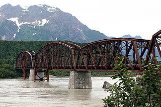
The Miles Glacier Bridge, also known as the Million Dollar Bridge, was built in the early 1900s across the Copper River fifty miles from Cordova in what is now the U.S. state of Alaska. It is a multiple-span Pennsylvania truss bridge which completed a 196-mile (315 km) railroad line for the Copper River and Northwestern Railway, built by J. P. Morgan and the Guggenheim family to haul copper from the old mining town of Kennicott, now located within the Wrangell–St. Elias National Park and Preserve, to the port of Cordova. It earned its nickname because of its $1.4 million cost, well recouped by the about $200 million worth of copper ore which was shipped as a result of its construction.
The Richardson Highway is a highway in the U.S. state of Alaska, running 368 miles (562 km) and connecting Valdez to Fairbanks. It is marked as Alaska Route 4 from Valdez to Delta Junction and as Alaska Route 2 from there to Fairbanks. It also connects segments of Alaska Route 1 between the Glenn Highway and the Tok Cut-Off. The Richardson Highway was the first major road built in Alaska.

Yukon–Charley Rivers National Preserve is a United States national preserve located in east central Alaska along the border with Canada. Managed by the National Park Service, the preserve encompasses 130 miles (208 km) of the 1,800-mile (3,000 km) Yukon River and the entire Charley River basin. The preserve protects the undeveloped Charley River and a significant portion of the upper Yukon. The interior Alaskan region experiences extremes of weather, with temperatures that can vary from −50 °F (−46 °C) in winter to 97 °F (36 °C) in summertime. The Yukon provided a means of access to the region, which is entirely roadless, during the late 19th century and early 20th centuries. Gold rushes in Alaska brought prospectors, who operated gold dredges to recover significant quantities of placer gold from area creeks. Today the preserve includes part of the route of the annual Yukon Quest dogsled race, which runs every February. During the summer float trips are popular on the Yukon and Charley Rivers.
The Nabesna Road is a minor highway in the U.S. state of Alaska that extends 42 miles (68 km) from the Slana River to Nabesna, providing access to some interior components of Wrangell-St. Elias National Park. The entire length of the road is gravel and has few services. Flat tires and washouts are fairly common along the entire length of the road.

Doyon, Limited, is one of thirteen Alaska Native Regional Corporations created under the Alaska Native Claims Settlement Act of 1971 (ANCSA) in settlement of aboriginal land claims. Doyon was incorporated in Alaska on June 26, 1972. Headquartered in Fairbanks, Alaska, Doyon is a for-profit corporation with about 18,000 Alaska Native shareholders primarily of Northern Athabaskan descent.

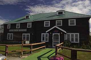
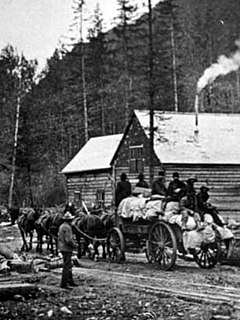
The Sourdough Lodge was built in Alaska between 1903 and 1905 of logs. It was one of a number of roadhouses built along the Valdez Trail. The roadhouses were about 15 miles (24 km) apart and offered shelter for travelers and road construction crews. It was designated a National Historic Landmark on June 2, 1978 as it was the oldest continuously-operating roadhouse in Alaska.
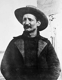
Felice Pedroni, known best to Americans by his Hispanicized alias Felix Pedro, was an Italian immigrant whose discovery of gold in Interior Alaska marked the beginning of the 1902 Fairbanks Gold Rush.

Slaven's Cabin, also called Slaven's Roadhouse and Frank Slaven Roadhouse, is a public-use facility in the Yukon-Charley Rivers National Preserve in Alaska. The cabin is located on the Yukon River, 42 miles (68 km) southeast of Circle, Alaska, and 138 miles (222 km) northeast of Fairbanks, Alaska. It is listed on the National Register of Historic Places.
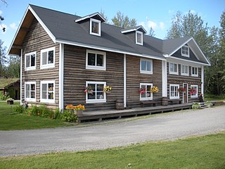
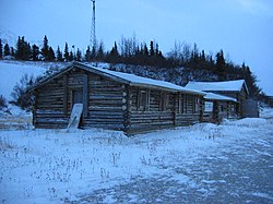
Rika's Landing Roadhouse, also known as Rika's Landing Site or the McCarty Roadhouse, is a roadhouse located at a historically important crossing of the Tanana River, in the Southeast Fairbanks Area, Alaska, United States. It is off mile 274.5 of the Richardson Highway in Big Delta.
The Board of Road Commissioners for Alaska, more commonly known as the Alaska Road Commission or ARC, was created in 1905 as a board of the U.S. War Department. It was responsible for the construction and improvement of many important Alaska highways, such as the Richardson Highway, Steese Highway, Elliot Highway and Edgerton Highway, among others.

Alaska Nellie's Homestead, located at Mile 23 of the Seward Highway in Kenai Peninsula Borough, Alaska, is the former homestead of Nellie Neal Lawing. Neal Lawing had migrated to Alaska in 1915 and ran a number of roadhouses for the Alaska Railroad before settling at the Roosevelt roadhouse on Kenai Lake in 1923, where she built her homestead. She planned to marry Kenneth Holden after settling, but he died in an industrial accident before their marriage; his cousin Billie Lawing then proposed to her, and the two married. A post office opened in the area in 1924; Nellie was the first postmistress, and the post office was named Lawing in her honor.

The Chicken Historic District encompasses part of the historic mining district of Chicken, Alaska. It is located at milepost 66.5 on the north side of the Taylor Highway, and includes fifteen buildings built between 1908 and 1967. Most of these are single-story wood-frame structures, with either metal or board-and-batten siding, although there are also some log structures. Many of these buildings were erected by the Fairbanks Exploration Company, which ran the gold mining operations in the area. Notable buildings include the bunkhouse, a gabled log structure, and the Chicken Creek Roadhouse, built in 1906, which was originally two stories in height but was reduced to a single story in 1924. The district also includes a section of water pipeline built by the company to bring water to the area from Mosquito Creek, a distance of about 1 mile (1.6 km). The camp was used until the company ended mining operations in 1967.

The Steele Creek Roadhouse is a historic roadhouse, post office, and trading post in east-central Alaska. It is located on the south side of the Fortymile River, at the mouth of Steele Creek, and is accessible via a hiking trail from mile 105 of the Taylor Highway, or by river access. It is a two-story log structure, 50 feet (15 m) wide and 25 feet (7.6 m) deep. Its first story was built c. 1898 by a man named Anderson, with the second story added in about 1910. It was on the main route between Eagle and Chicken between 1907 and 1951, serving travelers and local residents, until the Taylor Highway bypassed it. It underwent restoration in 2011.
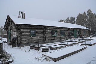
The Sullivan Roadhouse is a restored historic traveler's accommodation, operated as a museum in Delta Junction, Alaska. The roadhouse was added to the National Register of Historic Places in 1979.

The Solomon Roadhouse, also known as the Curran's Roadhouse, is a historic travel accommodation in northwestern Arctic Alaska. It is a two-story frame building located a short way north of the small community of Solomon, which is at the mouth of the Solomon River about 30 miles (48 km) east of Nome on the Nome-Council Highway. The roadhouse was built in 1904, during the days of the Nome Gold Rush, which brought many miners to the Solomon River as well, resulting in the establishment of the communities of Solomon and Dickson, and the construction of a railroad. After the gold rush declined and the communities were devastated by storms and floods, the roadhouse and other buildings were relocated about a mile north of the coast in the 1930s. The roadhouse operated until the 1970s.