
Falls Lake State Recreation Area is a North Carolina state park in Durham and Wake Counties, North Carolina in the United States. Near Wake Forest, North Carolina, it covers 5,035 acres (20.38 km2) along the shores of 12,410-acre (50.2 km2) Falls Lake.
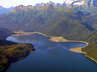
Admiralty Island is an island in the Alexander Archipelago in Southeast Alaska, at 57°44′N134°20′W. It is 145 km (90 mi) long and 56 km (35 mi) wide with an area of 4,264.1 km2 (1,646.4 sq mi), making it the seventh-largest island in the United States and the 132nd largest island in the world. It is one of the ABC islands in Alaska. The island is nearly cut in two by the Seymour Canal; to its east is the long, narrow Glass Peninsula. Most of Admiralty Island—955,747 acres (3,868 km2)—is protected as the Admiralty Island National Monument administered by the Tongass National Forest. The Kootznoowoo Wilderness encompasses vast stands of old-growth temperate rainforest. These forests provide some of the best habitat available to species such as brown bears, bald eagles, and Sitka black-tailed deer.
Little Beaver State Park is state park in Raleigh County, West Virginia. It is located near Beckley, West Virginia, about 2 miles (3.2 km) south of I-64 at Grandview Road, exit 129A. The park sits on the shores of 18-acre (0.07 km²) Little Beaver Lake.

The Alexander Lake Shelter Cabin is a historic backcountry shelter in the Admiralty Island National Monument. It is located at the eastern tip of Lake Alexander, on the Admiralty Island Canoe Route. The cabin is a three-sided Adirondack log shelter made of peeled logs covered with wood shakes. It was constructed by a Civilian Conservation Corps crew in 1935, and received maintenance from the United States Forest Service as recently as 1980.

The Big Shaheen Cabin, in the Admiralty Island National Monument near Angoon, Alaska, is a historic log cabin that was built by the Civilian Conservation Corps in 1935. It was listed on the National Register of Historic Places in 1995; the listing included the cabin and three other contributing structures.
The Davidson Lake Shelter Cabin is a historic three-sided log shelter located near Davidson Lake in the Admiralty Island National Monument. The structure was built in the 1930s by a crew of the Civilian Conservation Corps, a Great Depression-era works project of the United States government. The basic superstructure of the shelter is made of peeled logs, and the roof and walls are composed of wooden shakes. It is one of a series of CCC-built shelters along the Admiralty Island Canoe Route.

The Distin Lake Shelter Cabin is a historic backcountry shelter in the Admiralty Island National Monument. It is located on the northwest shore of Distin Lake, on the Admiralty Island Canoe Route. The cabin, originally a three-sided Adirondack log shelter, was constructed by a Civilian Conservation Corps crew in 1932. In 1960, a fourth wall, wooden floor, and bunk beds were added to the structure. There is a window, and the front door is one recycled from a theater; it is labeled "Balcony" on the inside.
The Hasselborg Cabin, also known as the Hasselborg Creek Cabin, is a backcountry shelter in the Admiralty Island National Monument, part of Tongass National Forest in Southeast Alaska. It is one of a number of such facilities built by Civilian Conservation Corps (CCC) on the Admiralty Island Canoe Route between 1933 and 1937. As built by the CCC, it was a three-sided Adirondack-style log shelter, timber-framed, and measuring about 12'6" by 10'6". It is one of only two cabins built on the route that has a fireplace; it is built of brick and stone. It is also distinctive for its floor, which is a concrete slab, whereas most other cabins originally had dirt floors. Its roof was originally wood shakes, but is now corrugated metal. The front has subsequently been enclosed.
The Hasselborg Lake East Shelter Cabin was a historic backcountry shelter in the Admiralty Island National Monument, part of Tongass National Forest in Southeast Alaska. The cabin, of which at best ruins survive today, was a three-sided Adirondack-style log structure, made of peeled logs, and covered with wood shakes. It was located near the mouth of the stream that drains Beaver Lake into Hasselborg Lake. The shelter was built in 1936 as part of a Civilian Conservation Corps works project to create a canoe route across the island.
The Hasselborg Lake North Shelter Cabin is a historic backcountry shelter in the Admiralty Island National Monument, part of Tongass National Forest in Southeast Alaska. The three-sided Adirondack-style log cabin, of which at best ruins survive today, was built in 1935 by a Civilian Conservation Corps work crew as part of a canoe route across the island. It is located at the northeast corner of Hasselborg Lake, where a poorly maintained or abandoned trail leads north to Windfall Harbor.
The Hasselborg Lake South Shelter Cabin is a historic backcountry shelter in the Admiralty Island National Monument, part of the Tongass National Forest in Southeast Alaska. It is one of a number of such facilities built by Civilian Conservation Corps (CCC) on the Admiralty Island Canoe Route between 1933 and 1937. The cabin is located on the southwest of Hasselborg Lake, north of the Hasselborg Cabin, and near the portage trail leading to Lake Guerin. As built by the CCC, it was a three-sided Adirondack-style log shelter with shake walls and roof. Sills and the lower ends of its posts have been replaced due to rot.
The Lake Guerin East Shelter Cabin is a historic backcountry shelter in the Admiralty Island National Monument, part of the Tongass National Forest in Southeast Alaska. It is one of a number of such facilities built by Civilian Conservation Corps (CCC) on the Admiralty Island Canoe Route between 1933 and 1937. This cabin, a three-sided Adirondack-style log structure with shake walls and roof, was built in 1935. As reported in 1995, only remnants of the cabin remain at the east of Lake Guerin, near a portage trail leading to Hasselborg Lake.
The Lake Guerin Shelter Lookout/Cabin, historically the Lake Guerin West Shelter Cabin is a historic backcountry shelter in the Admiralty Island National Monument, part of the Tongass National Forest in Southeast Alaska. It is one of a number of such facilities built by Civilian Conservation Corps (CCC) on the Admiralty Island Canoe Route between 1933 and 1937. This cabin, a three-sided Adirondack-style log structure with shake walls and roof, was built in 1936. The cabin continues to be maintained by the Forest Service.
The Mitchell Bay Shelter Lookout/Cabin is a historic backcountry shelter in the Admiralty Island National Monument, part of the Tongass National Forest in Southeast Alaska. It is one of a number of such facilities built by Civilian Conservation Corps (CCC) on the Admiralty Island Canoe Route between 1933 and 1937. This cabin, a three-sided Adirondack-style log structure with shake walls and roof, was built in 1936. The cabin, situated overlooking a tidal flat near the head of Mitchell Bay on the west side of the island, continues to be maintained by the Forest Service.
The Mole Harbor Shelter Lookout/Cabin is a historic backcountry shelter in the Admiralty Island National Monument, part of the Tongass National Forest in Southeast Alaska. It is one of a number of such facilities built by Civilian Conservation Corps (CCC) on the Admiralty Island Canoe Route between 1933 and 1937. This cabin, a three-sided Adirondack-style log structure with shake walls and roof, was built in 1936. The cabin, situated overlooking a tidal flat near the head of Mole Harbor on the east side of the island, continues to be maintained by the Forest Service. It is accessible via water, or by a trail from Lake Alexander.
The Thayer Lake East Shelter Cabin is the ruined remains of a historic backcountry shelter in the Admiralty Island National Monument, part of the Tongass National Forest in Southeast Alaska. It was one of a number of such facilities built by Civilian Conservation Corps (CCC) on the Admiralty Island Canoe Route between 1933 and 1937. This cabin, a three-sided Adirondack-style log structure with shake walls and roof, was built in 1936, and located on the lake near the portage trail connecting to Distin Lake. Unlike other cabins built by the CCC on the island, which were of post-and-beam construction, in this one the logs were saddle-notched together at the corners.
The Thayer Lake North Shelter Cabin is a historic backcountry shelter in the Admiralty Island National Monument, part of the Tongass National Forest in Southeast Alaska. It was one of a number of such facilities built by Civilian Conservation Corps (CCC) on the Admiralty Island Canoe Route between 1933 and 1937. This cabin, a three-sided Adirondack-style log structure with shake walls and roof, was built in 1935, and located at the northern tip of Thayer Lake, near a trailhead and a small log bridge.
The Thayer Lake South Shelter Cabin is a historic backcountry shelter in the Admiralty Island National Monument, part of the Tongass National Forest in Southeast Alaska. It was one of a number of such facilities built by Civilian Conservation Corps (CCC) on the Admiralty Island Canoe Route between 1933 and 1937. This cabin, a three-sided Adirondack-style log structure with shake walls and roof, was built in 1935, and is located near the southern tip of Thayer Lake, facing a reedy stream blocked by a beaver dam. A portage trail runs nearby.
The Windfall Harbor Shelter Cabin is a historic backcountry shelter in the Admiralty Island National Monument, part of the Tongass National Forest in Southeast Alaska. It was one of a number of such facilities built by Civilian Conservation Corps (CCC) on the Admiralty Island Canoe Route between 1933 and 1937. This cabin, a three-sided Adirondack-style log structure with shake walls and roof, is located near the southern end of Windfall Harbor, an inlet on the east side of Admiralty Island. The shelter underwent repairs in 1986. The Forest Service is in 2014 in the planning phases of a project to relocate the cabin a short distance to move it away from a major bear travel path.

Lake Leatherwood Park is a municipal park on the north side of Eureka Springs, Arkansas. The park covers 1,600 acres (650 ha), and its centerpiece is Lake Leatherwood, a 100-acre (40 ha) body of water created by the Lake Leatherwood Dam, which impounds West Leatherwood Creek. The dam, along with roadways, recreational facilities, and other elements of the park, were built in the 1930s by work crews of the Civilian Conservation Corps (CCC) with funding from the federal government's Soil Conservation Service.

