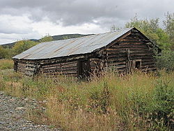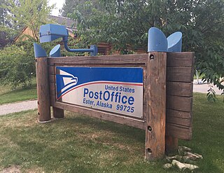
Ester is a census-designated place (CDP) in Fairbanks North Star Borough, Alaska, United States. It is part of the Fairbanks, Alaska Metropolitan Statistical Area. The population in the CDP was 2,422 at the 2010 census, although there are only around 12 houses located inside of the village, the rest are in the surrounding area. The Ester Camp Historic District is a historic district listed on the National Register of Historic Places. Ester was founded as a gold mining camp in the early 1900s, and the economy has focused on mining and services for miners. The Ester Volunteer Fire Department, John Trigg Ester Library, Ester Historic Society and Ester Post Office serve residents in Ester and surrounding areas. There is also a convenience store and secular chapel on the outskirts of the village. Many artists, writers, and musicians reside in Ester.

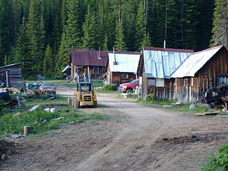
Chicken is a tiny unincorporated village in Southeast Fairbanks Census Area, Alaska. It is a community founded on gold mining, and is one of the few surviving gold rush towns in Alaska. The population was 12 at the time of the 2020 census, up from 7 in 2010. However, usually year round, there are 17 inhabitants. Due to mining, Chicken's population peaks during the summer. It has frequently been noted on lists of unusual place names. There is a cafe with gas station, a small hotel, an RV park, a small general store and a saloon located at Chicken.

Yukon–Charley Rivers National Preserve is a United States national preserve located in east central Alaska along the border with Canada. Managed by the National Park Service, the preserve encompasses 130 miles (208 km) of the 1,800-mile (3,000 km) Yukon River and the entire Charley River basin. The preserve protects the undeveloped Charley River and a significant portion of the upper Yukon. The interior Alaskan region experiences extremes of weather, with temperatures that can vary from −50 °F (−46 °C) in winter to 97 °F (36 °C) in summertime. The Yukon provided a means of access to the region, which is entirely roadless, during the late 19th century and early 20th centuries. Gold rushes in Alaska brought prospectors, who operated gold dredges to recover significant quantities of placer gold from area creeks. Today the preserve includes part of the route of the annual Yukon Quest dogsled race, which runs every February. During the summer float trips are popular on the Yukon and Charley Rivers.

The F.E. Company Dredge No. 4, also known as the Pedro Dredge and the Chicken Dredge, was originally owned by the Fairbanks Exploration Company, a subsidiary of the United States Smelting Refining & Mining Co. (USSR&M). It was built by the Yuba Manufacturing Company in California, and was shipped to Pedro Creek north of Fairbanks, Alaska in 1938. It was assembled there, and operated until 1958.

Menor's Ferry was a river ferry that crossed the Snake River near the present-day Moose, Wyoming, United States. The site was homesteaded by Bill Menor in 1892-94, choosing a location where the river flowed in a single channel, rather than the braided stream that characterizes its course in most of Jackson Hole. During the 1890s it was the only homestead west of the river. Menor's homestead included a five-room cabin, a barn, a store, sheds and an icehouse on 148 acres (60 ha), irrigated by a ditch from Cottonwood Creek and at times supplemented by water raised from the Snake River by a waterwheel. Menor operated the ferry until 1918, selling to Maude Noble, who continued operations until 1927, when a bridge was built at Moose.

The Coal Creek Historic Mining District is a gold-mining area in the Yukon-Charley Rivers National Preserve of Alaska dating from the 1930s. It features a gold dredge and a supporting community of several dozen buildings, established by mining entrepreneur Ernest Patty.

Goldstream Dredge No. 8 is a ladder dredge operated by the Fairbanks Exploration Company from 1928 to 1959. It is located on the old Steese Highway between Fairbanks and Fox in the central part of Alaska.

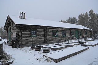
Slaven's Cabin, also called Slaven's Roadhouse and Frank Slaven Roadhouse, is a public-use facility in the Yukon-Charley Rivers National Preserve in Alaska. The cabin is located on the Yukon River, 42 miles (68 km) southeast of Circle, Alaska, and 138 miles (222 km) northeast of Fairbanks, Alaska. It is listed on the National Register of Historic Places.

The Tulpehocken Creek Historic District is a national historic district located in North Heidelberg Township, and Lower Heidelberg Township, Berks County, Pennsylvania. Encompassing a total of 17,000 acres, this district stretches from the Tulpehocken Creek and Mill Creek at the Berks County-Lebanon County line to the Blue March Dam between Bernville and Millardsville, and is composed of 152 contributing buildings, one contributing site, and four contributing structures which were related to the development which occurred along the upper Tulpehocken Creek from the early 18th century through the late 19th century. Historic buildings located here include early settlement period log cabins, which were built between 1723 and 1750; buildings related to the Charming Forge community, which existed between 1749 and 1895; an early 18th century cemetery and early 19th century church; buildings related to 18th and 19th century farming operations; and structures associated with the development and operation of the Union Canal.

The House of Wickersham, also known as the Wickersham State Historic Site, is a historic house at 213 7th Street in the Chicken Ridge area of Juneau, Alaska, United States. It is a historic house museum operated by the state of Alaska, memorializing the life of James Wickersham (1857-1939), an influential political leader in Alaska in the early 20th century. The house, a 2+1⁄2-story frame structure, was built in 1899 by Frank Hammond, owner of a mining company. It was purchased by Wickersham in 1928 and remained his home until his death. The house has been operated, informally at first by Wickersham's niece, as a museum since 1958. The house was purchased by the state in 1984.
The McCarthy Power Plant, also known as the Mother Lode Coalition Mining Company Power House and the Mother Lode Plant, is a historic power plant building in the small community of McCarthy, Alaska, in the heart of Wrangell-St. Elias National Park and Preserve. It is a three-story wood-frame structure with a clerestory roof, located on the banks of McCarthy Creek. It was built in 1917, after the arrival of the Copper River and Northwestern Railway in the area kicked of a building boom. The coal-fired power plant was built to provide electricity for the operation of a tramway and other facilities of the Kennecott mines. Most of the transmission lines and the tramway were destroyed by avalanches in 1919, and other changes made soon afterward made the power plant unnecessary, and its turbine was moved up to Kennecott.

The Steele Creek Roadhouse is a historic roadhouse, post office, and trading post in east-central Alaska. It is located on the south side of the Fortymile River, at the mouth of Steele Creek, and is accessible via a hiking trail from mile 105 of the Taylor Highway, or by river access. It is a two-story log structure, 50 feet (15 m) wide and 25 feet (7.6 m) deep. Its first story was built c. 1898 by a man named Anderson, with the second story added in about 1910. It was on the main route between Eagle and Chicken between 1907 and 1951, serving travelers and local residents, until the Taylor Highway bypassed it. It underwent restoration in 2011.
The Sullivan Roadhouse is a restored historic traveler's accommodation, operated as a museum in Delta Junction, Alaska, United States. The roadhouse was added to the National Register of Historic Places in 1979.

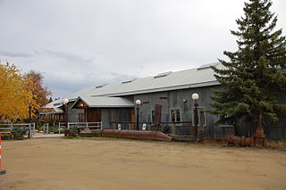
The Chatanika Gold Camp is a historic gold mining camp at Mile 27¾ of the Steese Highway in Chatanika, Alaska. The camp is set on about 49 acres (20 ha) overlooking Cleary Creek, and consists of thirteen buildings as well as a scattering of old mining tools and equipment. The largest of the buildings are two bunkhouses, finished in corrugated metal. The camp was built in 1925 by the Fairbanks Exploration Company (FEC), which also dug the nearby Davidson Ditch to supply water for the operation of the gold dredges. The Chatanika Camp was the largest of the FEC's mining camps in the Fairbanks area. Five of the surviving buildings date to the initial construction period.
The Chena Pump House, also known just as the Pump House Restaurant, is a restaurant at 796 Chena Pump Road in Fairbanks, Alaska. The restaurant is located in the shell of a 1933 pumping station established by the Fairbanks Exploration Company, Alaska's largest gold mining operator at the time. The pump house was used to provide water to dredges operating on Cripple Creek in the Ester area. The building was abandoned by the company in 1958, and was enlarged and converted into a restaurant in 1978. It was listed on the National Register of Historic Places in 1982.
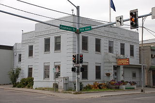
The Old City Hall, now the Fairbanks Distilling Company, is a historic civic building at 410 Cushman Street in Fairbanks, Alaska. It is a two-story Art Deco structure, built out of reinforced concrete in 1935 as a fireproof alternative to the city's previous city hall. The building is roughly T-shaped, with quoining patterns incised in the corners and bands of decoration on a parapet level. The building was originally built to house city offices as well as police and fire stations; the entrances to the fire equipment bays on Cushman Street have been filled in with wood framing and siding. The building was enlarged by extensions to the rear twice, once before 1950, and once after the 1967 floods. The city moved its offices to the adjacent Main School in 1994; the building then housed the Fairbanks Community Museum until it was acquired by Fairbanks Distilling Company in July 2014.

The Fairbanks Exploration Company Machine Shop is a historic machine shop in Fairbanks, Alaska, United States. Located behind the Fairbanks Exploration Company administration building at 612 Illinois Street, it is a large single-story steel-frame structure, built in 1927 to serve the company's nearby gold mining operations. Its easternmost section is 16 feet (4.9 m) high, while that on the west is 20 feet (6.1 m) high, in order to accommodate belt-driven equipment and cranes. A tall double door at the center of the east facade is the main entrance. The front of the building housed large belt-driven lathes, while the center had a welding shop, drill presses, and a tool room. A blacksmithy in the back had a sand floor. The building was used by the F.E. Company between 1927 and 1964.
The Fairbanks Exploration Company Dredge No. 2 is a historic gold mining dredge in a remote area of Fairbanks North Star Borough, Alaska, northeast of the city of Fairbanks. It is currently located on the north bank of Fish Creek, shortly northeast of the mouth of Slippery Creek. Its main structure is a compartmented steel hull, 128 feet (39 m) long, 60 feet (18 m) wide, and 12 feet (3.7 m) high, with a 1-2 story superstructure above made of steel and wood framing sheathed in corrugated metal. It has three gantries, and a digging ladder 112 feet (34 m) long at its bow that weights 178,000 pounds (81,000 kg). All of its original operating equipment was reported to be in place in 1999. The dredge was built in 1927 by the Bethlehem Steel Company, and assembled for use in Alaska in 1928. It was operated by the Fairbanks Exploration Company in the Goldstream Valley from 1928 to 1949, and on Fairbanks Creek and lower Fish Creek from 1950 to 1961.
The Gildersleeve Mine, in Lolo National Forest near Superior in Mineral County, Montana, was a gold and barite mine listed on the National Register of Historic Places in 2002.

The Rose Building was a historic commercial building in Fairbanks, Alaska. It was located on the west side of Illinois Street, north of the offices of the Fairbanks Daily News-Miner, and was a three-story log structure, capped by a steeply pitched gable roof. It is believed to have been built about 1912 in the mining community of Chena, and was moved to Fairbanks in 1925. It was named for Louis Rose, who purchased the building in 1938. It was, at the time of its demolition, the oldest commercial log building in the city, and was listed on the National Register of Historic Places in 1992. It was demolished in 1998 as part of the Illinois Street roadworks.