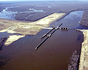
Overflow National Wildlife Refuge (NWR) is a 13,973 acre national wildlife refuge in Ashley County, Arkansas. Overflow NWR is one of three refuges forming an administrative complex, which also includes Felsenthal NWR and Pond Creek NWR to the west.
Pond Creek National Wildlife Refuge (NWR) is a 27,300 acre (110 km2) national wildlife refuge located in Sevier County, Arkansas. Pond Creek NWR is one of three refuges forming an administrative complex, which also includes Felsenthal NWR and Overflow NWR to the east.
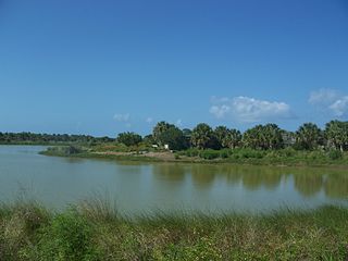
Pelican Island National Wildlife Refuge is a United States National Wildlife Refuge (NWR), and part of the Everglades Headwaters NWR complex, located just off the western coast of North Hutchinson Island in the Indian River Lagoon east of Sebastian, Florida. The refuge consists of a 3-acre (12,000 m2) island that includes an additional 2.5 acres (10,000 m2) of surrounding water and is located off the east coast of Florida of the Indian River Lagoon. Established by an executive order of President Theodore Roosevelt on March 14, 1903, Pelican Island was the first National wildlife refuge in the United States. It was created to protect egrets and other birds from extinction through plume hunting. The oldest government wildlife refuge of any kind in North America is the Lake Merritt Bird Refuge in Oakland, California. Oakland Mayor Samuel Merritt declared it a wildlife refuge for migrating birds in 1869. In 1870, the state of California designated Lake Merritt a state game refuge.

The Okefenokee National Wildlife Refuge is a 402,000‑acre (1,627 km2) National Wildlife Refuge located in Charlton, Ware, and Clinch Counties of Georgia, and Baker County in Florida, United States. The refuge is administered from offices in Folkston, Georgia. The refuge was established in 1937 to protect a majority of the 438,000 acre (1,772 km2) Okefenokee Swamp. Though often translated as "land of trembling earth", the name "Okefenokee" is likely derived from Hitchiti oki fanôːki "bubbling water".
The Alligator River National Wildlife Refuge is a 152,000-acre (620 km2) National Wildlife Refuge located in eastern North Carolina along the Atlantic Coast. It was established on March 14, 1984, to preserve and protect a unique wetland habitat type—the pocosin—and its associated wildlife species.
Camp Lake National Wildlife Refuge is a 585-acre (237 ha) National Wildlife Refuge (NWR) in the U.S. state of North Dakota. The refuge is an Easement refuge that is entirely on privately owned land, but the landowners and U.S. Government work cooperatively to protect the resources. The U.S. Fish and Wildlife Service oversees Camp Lake NWR from offices at Audubon National Wildlife Refuge.
Lake Otis National Wildlife Refuge is a 320-acre (130 ha) National Wildlife Refuge (NWR) in the U.S. state of North Dakota. The refuge is an Easement refuge that is entirely on privately owned land, but the landowners and U.S. Government work cooperatively to protect the resources. The U.S. Fish and Wildlife Service oversees Lake Otis NWR from offices at Audubon National Wildlife Refuge.
Lake Nettie National Wildlife Refuge is a 3,055-acre (1,236 ha) National Wildlife Refuge (NWR) in the U.S. state of North Dakota. 2,420 acres (980 ha) of the refuge are public while the remaining 635 acres (257 ha) is an easement on privately owned land, but the landowners and U.S. Government work cooperatively to protect the resources. The U.S. Fish and Wildlife Service oversees Lake Nettie NWR from offices at Audubon National Wildlife Refuge.
Hiddenwood National Wildlife Refuge is a 568-acre (230 ha) National Wildlife Refuge (NWR) in the U.S. state of North Dakota. The refuge is an Easement refuge that is entirely on privately owned land, but the landowners and U.S. Government work cooperatively to protect the resources. The U.S. Fish and Wildlife Service oversees Hiddenwood NWR from offices at Audubon National Wildlife Refuge.

Lost Lake National Wildlife Refuge is a 960-acre (390 ha) National Wildlife Refuge (NWR) in the U.S. state of North Dakota. Lost Lake NWR is an easement refuge and is on privately owned land, but the landowners and U.S. Government work cooperatively to protect the resources. The U.S. Fish and Wildlife Service oversees Lost Lake NWR from offices at Audubon National Wildlife Refuge.
McLean National Wildlife Refuge is a 760-acre (310 ha) National Wildlife Refuge (NWR) in the U.S. state of North Dakota. A little less than half the acreage of McLean NWR is on public lands, while the rest is an easement refuge and is on privately owned land, but the landowners and U.S. Government work cooperatively to protect the resources. The U.S. Fish and Wildlife Service oversees McLean NWR from their offices at Audubon National Wildlife Refuge. Originally called Lake Susie NWR, the name of the refuge was changed to its current title in the 1990s.

Pretty Rock National Wildlife Refuge is an 800-acre (320 ha) National Wildlife Refuge (NWR) in the U.S. state of North Dakota. Pretty Rock NWR is an easement refuge and is on privately owned land, but the landowners and U.S. Government work cooperatively to protect the resources. The U.S. Fish and Wildlife Service oversees Pretty Rock NWR from their offices at Audubon National Wildlife Refuge. This isolated refuge is 10 mi (16 km) south of New Leipzig, North Dakota and has been known as a temporary resting place for migrating whooping cranes. In 2002, six adults and one juvenile crane were spotted on the refuge.
Stewart Lake National Wildlife Refuge is a 2,230-acre (900 ha) National Wildlife Refuge (NWR) in the U.S. state of North Dakota. Almost 1,600 acres (650 ha) of Stewart Lake NWR is an easement refuge and is on privately owned land, but the landowners and U.S. Government work cooperatively to protect the resources. The remaining acreage is on public lands. The U.S. Fish and Wildlife Service oversees Stewart Lake NWR from their offices at Audubon National Wildlife Refuge.
Sheyenne Lake National Wildlife Refuge is an 800-acre (320 ha) National Wildlife Refuge (NWR) in the U.S. state of North Dakota. Sheyenne Lake NWR is an easement refuge and is on privately owned land, but the landowners and U.S. Government work cooperatively to protect the resources. The U.S. Fish and Wildlife Service oversees Sheyenne NWR from their offices at Audubon National Wildlife Refuge.
D'Arbonne National Wildlife Refuge is a National Wildlife Refuge of the United States located north of West Monroe, Louisiana. It is in Ouachita and Union Parishes on either side of Bayou D'Arbonne near its confluence with the Ouachita River. It lies on the western edge of the Mississippi River alluvial valley. It was established in 1975 to protect bottomland hardwoods and provide wintering habitat for migratory waterfowl. D'Arbonne is one of four refuges managed in the North Louisiana Refuges Complex.
Upper Ouachita National Wildlife Refuge was established in 1978 and is located in Union and Morehouse Parishes in northern Louisiana.

The Carolina Sandhills National Wildlife Refuge is a 45,348-acre (183.52 km2) national wildlife refuge (NWR) located in Chesterfield County, South Carolina. The refuge is managed by the U.S. Fish and Wildlife Service from a headquarters located in McBee, South Carolina. The refuge is served by U.S. Highway 1, which passes through it.

Piedmont National Wildlife Refuge is a 35,000-acre (140 km2) National Wildlife Refuge established in 1939 and located in central Georgia.
The John H. Chafee National Wildlife Refuge is a national wildlife refuge of the United States, located along the Narrow River on the southern coast of Rhode Island.
L’Aigle Creek is a waterway in Bradley County, Arkansas. It is 44.2 miles long. It flows into the Saline River. The Saline River flows into the Ouachita River.