
The history of the petroleum industry in the United States goes back to the early 19th century, although the indigenous peoples, like many ancient societies, have used petroleum seeps since prehistoric times; where found, these seeps signaled the growth of the industry from the earliest discoveries to the more recent.

Union County is a county located on the central southern border of the U.S. state of Arkansas. As of the 2010 census, the population was 41,639. The county seat is El Dorado. The county was formed on November 2, 1829, and named in recognition of the citizens' petition for a new county, which said that they were petitioning "in the spirit of Union and Unity." The county is directly adjacent to the south to Union Parish in the state of Louisiana.

El Dorado, founded by Matthew Rainey, is a city in, and the county seat of, Union County, on the southern border of Arkansas, United States. According to the 2010 census, the population of the city is 18,884.
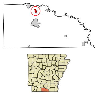
Norphlet is a city in Union County, Arkansas, United States. As of the 2010 census the population stood at 844.

Smackover is a small city in northern Union County, Arkansas, United States. According to the 2010 census, the population was at 1,865. It had a large oil boom in the 1920s, with production continuing for some time.

El Dorado is city and county seat of Butler County, Kansas, United States. It is situated along the Walnut River in the central part of Butler County and located in south-central Kansas. As of the 2020 census, the population of the city was 12,870. It is home to Butler Community College.

The Mid-continent oil field is a broad area containing hundreds of oil fields in Arkansas, Kansas, Louisiana, New Mexico, Oklahoma and Texas. The area, which consists of various geological strata and diverse trap types, was discovered and exploited during the first half of the 20th century. Most of the crude oil found in the onshore mid-continent oil field is considered to be of the mixed base or intermediate type.

South Arkansas lies within the southernmost portions of Arkansas Gulf Coastal Plain and Delta regions. It encompasses the lower 15 counties of the state.

The East Texas Oil Field is a large oil and gas field in east Texas. Covering 140,000 acres (57,000 ha) and parts of five counties, and having 30,340 historic and active oil wells, it is the second-largest oil field in the United States outside Alaska, and first in total volume of oil recovered since its discovery in 1930. Over 5.42 billion barrels of oil have been produced from it to-date. It is a component of the Mid-Continent Oil Province, the huge region of petroleum deposits extending from Kansas to New Mexico to the Gulf of Mexico.

Lion Oil Company is a private corporation engaged in refining and production of oil, gasoline, and oil-based products. It also manufactures asphalt, industrial solvents and roofing materials. It also operates a gathering and transportation system that moves oil products in interstate commerce. The company is based in Arkansas.

The Arkansas Timberlands is a region of the U.S. state of Arkansas generally encompassing the area south of the Ouachita Mountains, south of Central Arkansas and west of the Arkansas Delta. With several different definitions in use by various state agencies, the Arkansas Timberlands is essentially a region known for dense pine and cypress forests covering hilly terrain and lining numerous rivers. Modern settlement created a significant logging industry and subsequent clearance agriculture which provided the basis of the local economy until the discovery of petroleum. Local tourism is largely based on the popularity of deer hunting and bass fishing. Attractions there include Marks' Mills Battleground Historical Monument, Jenkins' Ferry Battleground Historical Monument, Overflow National Wildlife Refuge, Felsenthal National Wildlife Refuge, South Arkansas Arboretum, Arkansas Museum of Natural Resources, White Oak Lake State Park, Poison Springs Battleground State Park, Millwood State Park, and Pond Creek National Wildlife Refuge. The Arkansas Timberlands is the birthplace of former President of the United States Bill Clinton.
The economy of Arkansas produced US$119 billion of gross domestic product in 2015. Six Fortune 500 companies are based in Arkansas, including the world's #1 corporation by revenue, Walmart. Arkansas's per capita income for 2010 was $36,027. The three-year median household income from 2009-11 was $39,806, ranking forty-ninth in the nation.

The petroleum industry in Ohio dates from 1859. Ohio continues to produce significant quantities of oil and gas, having produced more than 1 billion barrels of oil and 9 trillion cubic feet of natural gas since 1860. Unconventional resources, primarily in eastern Ohio, are likely to increase production in Ohio.

The Texas oil boom, sometimes called the gusher age, was a period of dramatic change and economic growth in the U.S. state of Texas during the early 20th century that began with the discovery of a large petroleum reserve near Beaumont, Texas. The find was unprecedented in its size (worldwide) and ushered in an age of rapid regional development and industrialization that has few parallels in U.S. history. Texas quickly became one of the leading oil-producing states in the U.S., along with Oklahoma and California; soon the nation overtook the Russian Empire as the top producer of petroleum. By 1940 Texas had come to dominate U.S. production. Some historians even define the beginning of the world's Oil Age as the beginning of this era in Texas.
The Brown Dense limestone is an informal name used by petroleum geologists for a layer of rock that lies beneath large parts of southern Arkansas and northwest Louisiana. The Brown Dense is a 300- to 500-foot thick interval within organic-rich, fine-grained carbonate rock that comprise the Lower Member of the Smackover Formation. Within this area, the Lower Smackover Member lies at depths of 8,000 to 10,000 feet beneath the land surface.
The following is a timeline of the history of the city of Tulsa, Oklahoma, United States.

The Smackover Formation is a geologic formation in Arkansas. It preserves fossils dating back to the Jurassic period.
The geology of Arkansas includes deep 1.4 billion year old igneous crystalline basement rock from the Proterozoic known only from boreholes, overlain by extensive sedimentary rocks and some volcanic rocks. The region was a shallow marine, riverine and coastal environment for much of the early Paleozoic as multi-cellular life became commonplace. At the end of the Paleozoic in the Permian the region experienced coal formation and extensive faulting and uplift related to the Ouachita orogeny mountain building event. Extensive erosion of new highlands created a mixture of continental and marine sediments and much of the state remained flooded even into the last 66 million years of the Cenozoic. In recent Pleistocene and Holocene time, glacial sediments poured into the region from the north, down major rivers, forming dunes and sedimentary ridges. Today, Arkansas has an active oil and gas industry, although hydraulic fracturing related earthquake swarms have limited extraction. Mining industries in the state also produce brines, sand, gravel and other industrial minerals.

The discovery of the Glenn Pool Oil Reserve in 1905 brought the first major oil pipelines into Oklahoma, and instigated the first large scale oil boom in the state. Located near what was—at the time—the small town of Tulsa, Oklahoma, the resultant establishment of the oil fields in the area contributed greatly to the early growth and success of the city, as Tulsa became the petroleum and transportation center of the state, and the world.

