Pea Ridge National Military Park

Last updated

Pea Ridge National Military Park
Elkhorn Tavern Confederate Approach.jpg
Elkhorn Tavern at Pea Ridge National Military Park
USA Arkansas location map.svg
Red pog.svg
Map of Arkansas
Usa edcp location map.svg
Red pog.svg
Pea Ridge National Military Park (the United States)
Location Benton County, Arkansas,
United States
Nearest city Garfield
Coordinates 36°27′15.″N94°02′04.9″W / 36.45417°N 94.034694°W / 36.45417; -94.034694 Coordinates: 36°27′15.″N94°02′04.9″W / 36.45417°N 94.034694°W / 36.45417; -94.034694
Area4,300 acres (17 km2) [1]
EstablishedJuly 20, 1956 (1956-07-20) [2]
Visitors80,455(in 2020) [3]
Governing body National Park Service
Website Pea Ridge National Military Park
DesignatedOctober 15, 1966
Reference no.66000199 [4]

Pea Ridge National Military Park is a United States National Military Park located in northwest Arkansas near the Missouri border. The park protects the site of the Battle of Pea Ridge, fought March 7 and 8, 1862. The battle was a victory for the Union, and helped it gain control of the crucial border state of Missouri.

Contents

Administrative history

Pea Ridge area National Park Service map Pea ridge map USNPS.jpg
Pea Ridge area National Park Service map

The 4,300-acre (17 km2) Pea Ridge National Military Park was created by an act of Congress in 1956 to preserve the battlefield of the 1862 Battle of Pea Ridge. It was dedicated as a national park during the nation's Civil War Centennial in 1963. [5]

In 1956, the Arkansas congressional delegation proposed legislation to make Pea Ridge a national military park. This was a major breakthrough in American Civil War battlefield preservation. At that time, under the National Park Service classification system, only 1-acre (4,000 m2) should have been preserved, along with a monument. On July 20, 1956, Congress enacted legislation to accept a 5,000-acre (20 km2) donation from the state of Arkansas. [5]

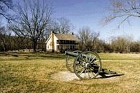
In acquiring the land for the park, the government purchased or used eminent domain on dozens of farms and residences of various sizes, ranging from a few acres to the large Winton Springs estate. Many of the houses and structures were sold and moved off of park property, including some that still stand in nearby Pea Ridge. All other remaining structures, with the exception of the historic Elkhorn Tavern, were demolished by the park, including the elaborate Winton Springs mansion.

Many Union and Confederate veterans attended several reunions at the Pea Ridge battlefield long before it was a park. The first of these reunions was held in 1887, twenty-five years after the battle. The reunions promoted not only remembrance, but healing between the soldiers of each side. The veterans dedicated the first monuments on the battlefield to both the Union and Confederate dead. Historian David W. Blight notes in his book Race and Reunion that in such postwar reconciliation, outstanding issues related to the condition and future of freedmen and racial justice were overlooked. [6] These monuments are still located within the park today. [5]

Visiting the park

The park is acknowledged as one of the best preserved Civil War battlefields. The park features a visitor center and museum, a driving tour, the restored battlefields, hiking trails, a portion of the pre-war Old Telegraph/Wire Road, approximately 2.5 miles (4.0 km) of the Trail of Tears as followed by some members of the Cherokee Nation, and the restored Elkhorn Tavern, which was the epicenter of much of the battle.

See also

Related Research Articles

Pea Ridge, Arkansas City in Arkansas

Pea Ridge is a city in Benton County, Arkansas, United States. The name Pea Ridge is derived from a combination of the physical location of the original settlement of the town, across the crest of an Ozark Mountains ridge, and for the hog peanuts or turkey peas that had been originally cultivated by Native American tribes centuries before European settlement, which later helped to provide basic subsistence once those pioneer settlers arrived.

Battle of Prairie Grove Battle of the American Civil War

The Battle of Prairie Grove was a battle of the American Civil War fought on December 7, 1862. While tactically indecisive, the battle secured the Union control of northwestern Arkansas.

Battle of Pea Ridge Battle of the American Civil War

The Battle of Pea Ridge, also known as the Battle of Elkhorn Tavern, took place in the American Civil War near Leetown, northeast of Fayetteville, Arkansas. Federal forces, led by Brig. Gen. Samuel R. Curtis, moved south from central Missouri, driving Confederate forces into northwestern Arkansas.

Kennesaw Mountain National Battlefield Park Public park and historic Civil War location in Cobb County, Georgia, United States

Kennesaw Battlefield Park preserves a Civil War battleground of the Atlanta Campaign, and also contains Kennesaw Mountain. It is located at 905 Kennesaw Mountain Drive, between Marietta and Kennesaw, Georgia. The name "Kennesaw" derives from the Cherokee Indian "Gah-nee-sah" meaning "cemetery" or burial ground. The area was designated as a U.S. historic district on October 15, 1966.

Fort Donelson National Battlefield preserves Fort Donelson and Fort Heiman, two sites of the American Civil War Forts Henry and Donelson Campaign, in which Union Army Brigadier General Ulysses S. Grant and Flag Officer Andrew Hull Foote captured three Confederate forts and opened two rivers, the Tennessee River and the Cumberland River, to control by the Union Navy. The commanders received national recognition for their victories in February 1862, as they were the first major Union successes of the war. The capture of Fort Donelson and its garrison by the Union led to the capture of Tennessee's capital and industrial center, Nashville, which remained in Union hands from February 25, 1862 until the end of the war, and gave the Union effective control over much of Tennessee. This struck a major blow to the Confederacy early in the war.

Monocacy National Battlefield is a unit of the National Park Service, the site of the Battle of Monocacy in the American Civil War fought on July 9, 1864. The battlefield straddles the Monocacy River southeast of the city of Frederick, Maryland. The battle, labeled "The Battle That Saved Washington," was one of the last the Confederates would carry out in Union territory. The two opposing leaders were General Jubal Early, fighting for the South, and General Lew Wallace, fighting for the North.

Shiloh National Military Park United States historic area

Shiloh National Military Park preserves the American Civil War Shiloh and Corinth battlefields. The main section of the park is in the unincorporated town of Shiloh, about nine miles (14 km) south of Savannah, Tennessee, with an additional area located in the city of Corinth, Mississippi, 23 miles (37 km) southwest of Shiloh. The Battle of Shiloh began a six-month struggle for the key railroad junction at Corinth. Afterward, Union forces marched from Pittsburg Landing to take Corinth in a May siege, then withstood an October Confederate counter-attack.

Vicksburg National Military Park American Civil War historic site

Vicksburg National Military Park preserves the site of the American Civil War Battle of Vicksburg, waged from March 29 to July 4, 1863. The park, located in Vicksburg, Mississippi, also commemorates the greater Vicksburg Campaign which led up to the battle. Reconstructed forts and trenches evoke memories of the 47-day siege that ended in the surrender of the city. Victory here and at Port Hudson, farther south in Louisiana, gave the Union control of the Mississippi River.

Chickamauga and Chattanooga National Military Park Preserved battlefields of the American Civil War in Georgia and Tennessee, United States

Chickamauga and Chattanooga National Military Park, located in northern Georgia and southeastern Tennessee, preserves the sites of two major battles of the American Civil War: the Battle of Chickamauga and the Siege of Chattanooga. A detailed history of the park's development was provided by the National Park Service in 1998.

Harpers Ferry National Historical Park Park at confluence of Virginia, West Virginia and Maryland in the United States

Harpers Ferry National Historical Park, originally Harpers Ferry National Monument, is located at the confluence of the Potomac and Shenandoah rivers in and around Harpers Ferry, West Virginia. The park includes the historic center of Harpers Ferry, notable as a key 19th-century industrial area and as the scene of John Brown's failed abolitionist uprising. It contains the most visited historic site in the state of West Virginia, John Brown's Fort.

Antietam National Battlefield Historical area from the American Civil War

Antietam National Battlefield is a National Park Service-protected area along Antietam Creek in Sharpsburg, Washington County, northwestern Maryland. It commemorates the American Civil War Battle of Antietam that occurred on September 17, 1862.

Fredericksburg and Spotsylvania National Military Park 8,000 acres in Virginia (US) managed by the National Park Service

Fredericksburg and Spotsylvania National Military Park is a unit of the National Park Service in Fredericksburg, Virginia, and elsewhere in Spotsylvania County, commemorating four major battles in the American Civil War: Fredericksburg, Chancellorsville, The Wilderness, and Spotsylvania.

Stones River National Battlefield, a 570-acre (2.3 km2) park along the Stones River in Rutherford County, Tennessee, three miles (5 km) northwest of Murfreesboro and twenty-eight miles southeast of Nashville, memorializes the Battle of Stones River. This key battle of the American Civil War occurred on December 31, 1862 and January 2, 1863, and resulted in a strategic Union victory.

Wilsons Creek National Battlefield National battlefield in Missouri, United States

Wilson's Creek National Battlefield, located near Republic, Missouri, preserves the site of the Battle of Wilson's Creek. Fought on August 10, 1861, the battle was the first major American Civil War engagement west of the Mississippi River. In the battle, a Confederate army commanded by Benjamin McCulloch and Sterling Price defeated a smaller Union army commanded by Nathaniel Lyon. However, the Confederates were unable to hold much of Missouri, and a Confederate defeat at the Battle of Pea Ridge effectively solidified Union control of the state. Major features include a five-mile automobile tour loop, the restored 1852 Ray House, and "Bloody Hill," the site of the final stage of the battle. The site is located near Republic in southwestern Missouri just southwest of the city of Springfield. It has been a unit of the National Park Service since 1960, and was listed on the National Register of Historic Places in 1966.

Manassas National Battlefield Park 5,000 acres in Virginia (US) maintained by the National Park Service

Manassas National Battlefield Park is a unit of the National Park Service located in Prince William County, Virginia, north of Manassas that preserves the site of two major American Civil War battles: the First Battle of Bull Run, also called the First Battle of Manassas, and the Second Battle of Bull Run or Second Battle of Manassas. It was also where Confederate General Thomas J. Jackson acquired his nickname "Stonewall". The park was established in 1936 and listed on the National Register of Historic Places on October 15, 1966.

Elkhorn Tavern is a two-story, wood-frame structure that served as a physical center for the American Civil War Battle of Pea Ridge, also known as the Battle of Elkhorn Tavern, which was fought on March 7 and March 8, 1862, approximately five miles east of Pea Ridge, Arkansas, located in the northeastern Benton County, Arkansas. The tavern, a replica built in 1865 following the burning of the original building by bushwhackers, is now the centerpiece of the Pea Ridge National Military Park, which includes approximately 5,000 acres (2,000 ha) around the structure, including the restored battlefields, a stretch of the pre-war Telegraph Road, which runs directly in front of the tavern, and a section of the Trail of Tears. The tavern is on the National Register of Historic Places.

Perryville Battlefield State Historic Site

Perryville Battlefield State Historic Site is a 745-acre (3.01 km2) park near Perryville in Boyle County, Kentucky. The park continues to expand with purchases of parcels by the Office of Kentucky Nature Preserves' Kentucky Heritage Land Conservation Fund and the American Battlefield Trust. An interpretive museum is located near the site where many Confederate soldiers killed in the Battle of Perryville were buried. Additionally, monuments, interpretive signage, and cannons mark notable events that occurred during the battle. The site became part of the Kentucky State Park System in 1936.

The Civil War Trust's Civil War Discovery Trail is a heritage tourism program that links more than 600 U.S. Civil War sites in more than 30 states. The program is one of the White House Millennium Council's sixteen flagship National Millennium Trails. Sites on the trail include battlefields, museums, historic sites, forts and cemeteries.

Springfield to Fayetteville Road-Elkhorn Tavern Segment United States historic place

The Springfield to Fayetteville Road-Elkhorn Tavern Segment is a section of historic 19th-century roadway in Pea Ridge National Military Park in northwestern Arkansas. It is a dirt road, about 1 mile (1.6 km) long and 18 to 20 feet wide, that was built in 1835. The first major road through northwestern Arkansas, it connected Fayetteville, Arkansas with Springfield, Missouri. The road was part of the major northern route of the Trail of Tears, the forcible remove in the late 1830s of Native Americans from east of the Mississippi River to what is now Oklahoma. The road was also actively used by both Union and Confederate forces during the American Civil War, and was the major route of advance by Confederate forces leading to the Battle of Pea Ridge, whose battlefield is preserved by the park.

Leetown, also known as Lee Town, was a historic village in Benton County, Arkansas, United States. The first day of the Battle of Pea Ridge was fought around Leetown.

References

  1. "Listing of acreage – December 31, 2020" (XLSX). Land Resource Division, National Park Service. Retrieved August 15, 2021. (National Park Service Acreage Reports)
  2. "Park Anniversaries" . Retrieved August 13, 2021.
  3. "NPS Annual Recreation Visits Report". National Park Service. Retrieved April 30, 2021.
  4. "National Register Information System". National Register of Historic Places . National Park Service. July 9, 2010.
  5. 1 2 3 Warren, Steven L. Pea Ridge National Military Park, The Encyclopedia of Arkansas History and Culture.
  6. Foner, Eric (March 4, 2001). "Selective Memory" . The New York Times. sect. 7, p. 28. Retrieved November 28, 2019.
Government
General information