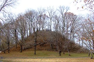
The Pinson Mounds comprise a prehistoric Native American complex located in Madison County, Tennessee in the region that is known as the Eastern Woodlands. The complex, which includes 17 mounds, an earthen geometric enclosure, and numerous habitation areas, was most likely built during the Middle Woodland period. The complex is the largest group of Middle Woodland mounds in the United States. Sauls' Mound, at 72 feet, is the second-highest surviving mound in the United States.

The Great Serpent Mound is a 1,348-foot (411 m)-long, three-foot-high prehistoric effigy mound on a plateau of the Serpent Mound crater along Ohio Brush Creek in Adams County, Ohio. Maintained within a park by Ohio History Connection, it has been designated a National Historic Landmark by the United States Department of Interior. The Serpent Mound of Ohio was first reported from surveys by Ephraim Squire and Edwin Davis in their historic volume Ancient Monuments of the Mississippi Valley, published in 1848 by the newly founded Smithsonian Museum.
In archaeology, timber circles are circular arrangements of wooden posts interpreted as being either complexes of freestanding totem poles or as the supports for large circular buildings.
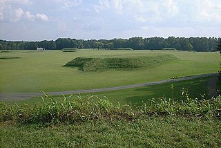
Moundville Archaeological Site, also known as the Moundville Archaeological Park, is a Mississippian culture site on the Black Warrior River in Hale County, near the city of Tuscaloosa, Alabama. Extensive archaeological investigation has shown that the site was the political and ceremonial center of a regionally organized Mississippian culture chiefdom polity between the 11th and 16th centuries. The archaeological park portion of the site is administered by the University of Alabama Museums and encompasses 185 acres (75 ha), consisting of 29 platform mounds around a rectangular plaza.

The Horr's Island archaeological site is a significant Archaic period archaeological site located on an island in Southwest Florida formerly known as Horr's Island. Horr's Island is on the south side of Marco Island in Collier County, Florida. The site includes four mounds and a shell ring. It has one of the oldest known mound burials in the eastern United States, dating to about 3400 radiocarbon years Before Present (BP). One of the mounds has been dated to as early as 6700 BP. It was the largest known community in the southeastern United States to have been permanently occupied during the Archaic period.

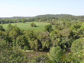
The Old Stone Fort is a prehistoric Native American structure located in Coffee County, Tennessee, in the Southeastern United States. The structure was most likely built between 80 and 550 AD during the Middle Woodland period. It is the most complex hilltop enclosure found in the South and was likely used for ceremonial purposes rather than defense.
Mound Bottom is a prehistoric Native American complex in Cheatham County, Tennessee, located in the Southeastern United States. The complex, which consists of earthen platform and burial mounds, a 7-acre central plaza, and habitation areas, was occupied between approximately 1000 and 1300 AD, during the Mississippian period.

Toqua was a prehistoric and historic Native American site in Monroe County, Tennessee, located in the southeastern United States. Along with the Overhill Cherokee village for which the site was named, Toqua was home to a substantial pre-Cherokee town that thrived during the Mississippian period (1000-1600). One of the Toqua site's most outstanding features was a 25-foot (7.6 m) platform mound built by the town's Mississippian inhabitants. The site's Mississippian occupation may have been the village of Tali, which was visited by the Hernando de Soto expedition in 1540.

Leake Mounds (9BR2) is an important archaeological site in Bartow County, Georgia built and used by peoples of the Swift Creek Culture. The site is 2 miles (3.2 km) west of Etowah Mounds on the Etowah River, although it predates that site by hundreds of years. Excavation of nearly 50,000 square feet (4,600 m2) on the site showed that Leake Mounds was one of the most important Middle Woodland period site in this area from around 300 BCE to 650 CE, a center with ties throughout the Southeast and Midwest. It was abandoned about 650 CE and not occupied again until by different peoples near the end of the Mississippian culture period, about 1500.

The Medora Site (16WBR1) is an archaeological site that is a type site for the prehistoric Plaquemine culture period. The name for the culture is taken from the proximity of Medora to the town of Plaquemine, Louisiana. The site is in West Baton Rouge Parish, Louisiana, and was inhabited from approximately 1300 to 1600 CE. It consisted of two mounds separated by a plaza. In the winter of 1939-40 excavation of this site was undertaken by the Louisiana State Archaeological Survey, a joint project of Louisiana State University and the Work Projects Administration. It was directed by James A. Ford, and George I. Quimby. The excavations of the site were instrumental in defining the characteristics of the Plaquemine period and culture.

Old Town is an archaeological site in Williamson County, Tennessee near Franklin. The site includes the remnants of a Native American village and mound complex of the Mississippian culture, and is listed on the National Register of Historic Places (NRHP) as Old Town Archaeological Site (40WM2).

Poverty Point State Historic Site is a prehistoric earthwork constructed by the Poverty Point culture. The Poverty Point site is located in present-day northeastern Louisiana though evidence of the Poverty Point culture extends throughout much of the Southeastern United States. The culture extended 100 miles (160 km) across the Mississippi Delta and south to the Gulf Coast. The Poverty Point site has been designated as a U.S. National Monument, a U.S. National Historic Landmark, and UNESCO World Heritage Site. Located in the Southern United States, the site is 15.5 miles (24.9 km) from the current flow of the Mississippi River, and is situated on the edge of Macon Ridge, near the village of Epps in West Carroll Parish, Louisiana.

The Beasley Mounds Site (40SM43) is a Mississippian culture archaeological site located at the confluence of Dixon Creek and the Cumberland River near the unincorporated community of Dixon Springs in Smith County, Tennessee. The site was first excavated by amateur archaeologists in the 1890s. More examples of Mississippian stone statuary have been found at the site than any other in the Middle Tennessee area. The site was listed on the National Register of Historic Places in 2010.

Marsden Mounds is an archaeological site with components from the Poverty Point culture and the Troyville-Coles Creek period. It is located in Richland Parish, Louisiana, near Delhi. It was added to the NRHP on August 4, 2004, as NRIS number 04000803. It is the type site for the Marsden Phase of the Tensas Basin and Natchez Bluff regions local chronology.
The Park Mound Site (9TP41) is a destroyed archaeological site located near Yellow Jacket Creek in Troup County, Georgia, USA. It was investigated by Harold Huscher and a team of University of Georgia students in the early 1970s.

The Little Egypt site was an archaeological site located in Murray County, Georgia, near the junction of the Coosawattee River and Talking Rock Creek. The site originally had three platform mounds surrounding a plaza and a large village area. It was destroyed during the construction of the Dam of Carters Lake in 1972. It was situated between the Ridge and Valley and Piedmont sections of the state in a flood plain. Using Mississippian culture pottery found at the site archaeologists dated the site to the Middle and Late South Appalachian culture habitation from 1300 to 1600 CE during the Dallas, Lamar, and Mouse Creek phases.
Bell Field Mound Site is an archaeological site located on the western bank of the Coosawattee River below the Coosawatee’s junction with Talking Rock Creek. The site itself was destroyed by the construction of Carters Dam in the 1970s. With respect to the dam itself, Bell Field was located in front of the high dam along with the Sixtoe Mound and Little Egypt sites.
The Sixtoe Mound site (9MU100) is an archaeological site in Murray County, Georgia excavated by Arthur Randolph Kelly from 1962-1965 as a part of the Carters Dam project conducted for the National Park Service by the University of Georgia. The site consisted of a low platform mound and an associated village. The majority of the mound was excavated, while the village received little excavation.
The Lamar Mounds and Village Site (9BI2) is an important archaeological site on the banks of the Ocmulgee River in Bibb County, Georgia and several miles to the southeast of the Ocmulgee Mound Site. Both mound sites are part of the Ocmulgee National Monument, a national park and historic district created in 1936 and run by the U.S. National Park Service. Historians and archaeologists have theorized that the site is the location of the main village of the Ichisi encountered by the Hernando de Soto expedition in 1539.


