Medora Site

Last updated
Medora Site
16 WBR 1
Medora Site map HRoe 2009.jpg
Diagram of the Medora Site
USA Louisiana location map.svg
Archaeological site icon (red).svg
Location within Louisiana today
Location Plaquemine, Louisiana,  West Baton Rouge Parish, Louisiana,  United States
RegionWest Baton Rouge Parish, Louisiana
Coordinates 30°19′36.34″N91°12′5.65″W / 30.3267611°N 91.2015694°W / 30.3267611; -91.2015694
History
Founded1300 CE
Cultures Plaquemine culture
Site notes
Excavation dates1939-1940
Archaeologists James A. Ford, George I. Quimby
Architecture
Architectural styles Platform mounds, Plaza
Responsible body: private

The Medora Site (16WBR1) is an archaeological site that is a type site for the prehistoric Plaquemine culture period. The name for the culture is taken from the proximity of Medora to the town of Plaquemine, Louisiana. [1] The site is in West Baton Rouge Parish, Louisiana, and was inhabited from approximately 1300 to 1600 CE. It consisted of two mounds separated by a plaza. In the winter of 1939-40 excavation of this site was undertaken by the Louisiana State Archaeological Survey, a joint project of Louisiana State University and the Work Projects Administration. It was directed by James A. Ford, and George I. Quimby. The excavations of the site were instrumental in defining the characteristics of the Plaquemine period and culture. [2]

Contents

The Medora site

Location

A map showing the geographical extent of the Plaquemine culture, including the Medora site. Plaquemine culture map HRoe 2010.jpg
A map showing the geographical extent of the Plaquemine culture, including the Medora site.

The Medora Site is located in West Baton Rouge Parish, Louisiana adjacent to Bayou Bourbeaux (or Bourbeau or Bourbaux) on the flood plain of Manchac Point (also called Australia Point). Manchac Point is a hair-pin bend of the Mississippi River. Bayou Bourbeaux, a point stream which flows away from the river to the west, drains the back slopes of the natural levees that border Manchac Point, and connects with Bayou Gross Tete. The land surrounding the site is wet and subject to annual flooding, being only twenty feet above sea level. The site is part of the Medora Plantation, after which it is named, and had been cultivated for many years prior to the excavation. [2]

Date

It was possible to date the site by geological and archaeological means and obtain an estimate of the period of time in which the site was occupied. According to the Louisiana Geological Survey abandoned river course maps of Harold Norman Fisk, a meander of the Mississippi River began migrating from north to south across the area now occupied by Manchac Point at stage 9 (900 CE). The land of which Manchac Point is composed was not built up behind the meander until the beginning of stage 13 (1300 CE), meaning it was not suitable for habitation until then. And since all artifacts found at the site were from the Plaquemine period and not the succeeding Natchez period which begins in 1700, the dates for occupation are approximately from 1300 to 1600 CE. [2]

Mounds

The main part of the Medora Site is a pyramid and plaza arrangement. Mound A is a platform mound about 125 feet (38 m) to 130 feet (40 m) at the base and 10 feet (3.0 m) high. The sides sloped inward toward the top, which is flat, except for a conical projection 25 feet (7.6 m) in diameter in the northeast corner of the summit that raises the gross elevation to 13 feet (4.0 m). It was probably surmounted by a square or rectangular temple. About 400 feet (120 m) to the southeast of Mound A was a low mound about 100 feet (30 m) in diameter and 5 feet (1.5 m) high, designated Mound B. Although it has been modified by plowing and flood waters, and is now only about 2 feet (0.61 m) high. It was flat-topped, with an irregular oval outline. Its pre-mound surface was found to have a wall-trench structure, probably a house or temple. The floor contained patches of burned clay and fragments of charcoal. At the center there was a rounded fire basin 2 feet (0.61 m) in diameter and six inches deep, lined with burned clay. The mounds were composed of gray clay and brown silt, applied basket load at a time. Between Mounds A and B was a plaza about 400 feet (120 m) long and 200 feet (61 m) wide. Its west side bordered Bayou Bourbeaux. [2]

Artifacts

Pottery

Plaquemine culture pottery from the Winterville Site, a Plaquemine site in Mississippi Winterville pottery HRoe 2004.jpg
Plaquemine culture pottery from the Winterville Site, a Plaquemine site in Mississippi

About 18,508 pottery sherds were obtained from the Medora Site, classified into more than twenty different Plaquemine culture pottery types. About 90 per cent were classified as the Addis Plain variety, although Plaquemine Brushed; Manchac Incised; Hardy Incised; Medora Incised; Harrison Bayou Incised; Evangeline Interior Incised; Australia Interior Incised; L'Eau Noire Incised; Dupree Incised; Lulu Linear Punctated; Chevalier Stamped, Coles Creek Incised, Larto Red Filmed, and Pontchartrain Check Stamped were also present. [2]

The pottery of the Medora Site was uniform in paste characteristics, soft, clay-tempered, and poorly fired, with the exception of a few shell-tempered sherds. The color generally ranges in grays and tans, with a smooth surface finish that feels soft and chalky to the touch. Although the vast majority of the pottery was plain, about 10 percent had decorative elements applied. The designs were usually simple arrangements of lines, made by incising, engraving, brushing, and punctating, with incising and brushing the most common technique. A few of the type L'Eau Noire Incised have complicated curvilinear elements. The designs are usually placed on the exterior vessel wall, mostly confined to the rim. The most common vessel forms were jars and bowls, with some cups and carinated bowls. [2]

Stone

Although more than 18,000 pottery sherds were found, only seven artifacts of stone were found at the Medora Site. Reddish pebbles of flinty stone were found in Mound A, even though they do not naturally occur in the vicinity of the Medora Site. They must have been brought there, possibly from the Natchez, Mississippi vicinity. Only three projectile points of chipped flint were found at the site, although several objects of polished greenstone and sandstone were found. Two ovate-oblong greenstone celts and a sandstone discoidal were found in the fill of Mound A. A spoon-shaped object of ground and polished greenstone was found in the fill Mound B. A discoidal was probably used in the well-known game of chunkey, which was played by almost all of the historic Indians of the Southeast. It is very likely that chunkey was played ceremonially in the plaza of the Medora Site. A cylindrical earspool of fired clay with flat faces and straight sides was found in Mound A. It was 3 centimetres (1.2 in) in diameter and 1.8 centimetres (0.71 in) thick, with engraved geometric designs composed of a circle and curvilinear elements. [2]

Excavations

The land is part of the Medora Plantation, after which the site is named, and had been cultivated for many years prior to the excavation.In the winter of 1939-40 excavation of this site was undertaken by the Louisiana State Archaeological Survey, a joint project of Louisiana State University and the Work Projects Administration. It was directed by James A. Ford, and George I. Quimby. The excavations of the site were instrumental in defining the characteristics of the Plaquemine period and culture. Permission to investigate this site was given by the owner of the land, W. L. Grace, Jr., of Plaquemine, Louisiana. [2]

See also

Related Research Articles

West Baton Rouge Parish, Louisiana Parish in Louisiana

West Baton Rouge Parish is one of the sixty-four parishes in the U.S. state of Louisiana. As of the 2010 census, the population was 23,788. The parish seat is Port Allen. The parish was created in 1807.

Mound Builders Pre-Columbian cultures of North America that constructed various styles of earthen mounds

The various cultures collectively termed "Mound Builders" were prehistoric, indigenous inhabitants of North America who, during a 5,000-year period, constructed various styles of earthen mounds for religious, ceremonial, burial, and elite residential purposes. These included the pre-Columbian cultures of the Archaic period, Woodland period, and Mississippian period; dating from roughly 3500 BCE to the 16th century CE, and living in regions of the Great Lakes, the Ohio River Valley, and the Mississippi River valley and its tributary waters.

Chunkey

Chunkey is a game of Native American origin. It was played by rolling disc-shaped stones across the ground and throwing spears at them in an attempt to land the spear as close to the stopped stone as possible. It originated around 600 CE in the Cahokia region of what is now the United States. Chunkey was played in huge arenas as large as 47 acres that housed great audiences designed to bring people of the region together. It continued to be played after the fall of the Mississippian culture around 1500 CE. Variations were played throughout North America. Early ethnographer James Adair translated the name to mean "running hard labor". Gambling was frequently connected with the game, with some players wagering everything they owned on the outcome of the game. Losers were even known to commit suicide.

The Taensa were a Native American people whose settlements at the time of European contact in the late 17th century were located in present-day Tensas Parish, Louisiana. The meaning of the name, which has the further spelling variants of Taenso, Tinsas, Tenza or Tinza, Tahensa or Takensa, and Tenisaw, is unknown. It is believed to be an autonym. The Taensa should not be confused with the Avoyel, known by the French as the petits Taensas, who were mentioned in writings by explorer Pierre Le Moyne d'Iberville in 1699. The Taensa are more closely related to the Natchez people and both are considered descendants of the late prehistoric Plaquemine culture.

James Alfred Ford was an American archaeologist. He was born in Water Valley, Mississippi, in February 1911. He became interested in work on Native American mound research while growing up in Mississippi.

Kincaid Mounds State Historic Site Archaeological site in Illinois, US

The Kincaid Mounds Historic Site c. 1050–1400 CE, is a Mississippian culture archaeological site located at the southern tip of present-day U.S. state of Illinois, along the Ohio River. Kincaid Mounds has been notable for both its significant role in native North American prehistory and for the central role the site has played in the development of modern archaeological techniques. The site had at least 11 substructure platform mounds, and 8 other monuments.

Anna Site

The Anna Site is a prehistoric Plaquemine culture archaeological site located in Adams County, Mississippi 10 miles (16 km) north of Natchez. It is the type site for the Anna Phase of the Natchez Bluffs Plaquemine culture chronology. It was declared a National Historic Landmark on September 14, 1993.

Coles Creek culture

Coles Creek culture is a Late Woodland archaeological culture in the Lower Mississippi valley in the Southeastern Woodlands. It followed the Troyville culture. The period marks a significant change in the cultural history of the area. Population increased dramatically and there is strong evidence of a growing cultural and political complexity, especially by the end of the Coles Creek sequence. Although many of the classic traits of chiefdom societies are not yet manifested, by 1000 CE the formation of simple elite polities had begun. Coles Creek sites are found in Arkansas, Louisiana, and Mississippi. It is considered ancestral to the Plaquemine culture.

Plaquemine culture

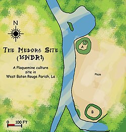
The Plaquemine culture was an archaeological culture centered on the Lower Mississippi River valley. It had a deep history in the area stretching back through the earlier Coles Creek and Troyville cultures to the Marksville culture. The Natchez and related Taensa peoples were their historic period descendants. The type site for the culture is the Medora Site in Louisiana; while other examples include the Anna, Emerald, Holly Bluff, and Winterville sites in Mississippi.

Aden Site Archaeological type site

The Aden Site is an archaeological site that is the type site for the Aden Phase of Lower Yazoo Basin Coles Creek culture chronology. It corresponds to Middle Coles Creek, chronologically between the Bayland Phase and Kings Crossing Phase.

Tchefuncte Site Archaeological site of the prehistoric Tchefuncte culture

The Tchefuncte Site (16ST1) is an archaeological site that is a type site for the prehistoric Tchefuncte culture period. The name is pronounced Che-funk'tuh. It is located in the southeast section of Fontainebleau State Park near Mandeville, St. Tammany Parish, Louisiana.

Marksville culture

The Marksville culture was an archaeological culture in the lower Lower Mississippi valley, Yazoo valley, and Tensas valley areas of present-day Louisiana, Mississippi, Arkansas, and extended eastward along the Gulf Coast to the Mobile Bay area, from 100 BCE to 400 CE. This culture takes its name from the Marksville Prehistoric Indian Site in Avoyelles Parish, Louisiana. Marksville Culture was contemporaneous with the Hopewell cultures within present-day Ohio and Illinois. It evolved from the earlier Tchefuncte culture and into the Baytown and Troyville cultures, and later the Coles Creek and Plum Bayou cultures. It is considered ancestral to the historic Natchez and Taensa peoples.

Ghost Site Mounds Archaeological site in Tensas Parish, Louisiana, United States

Ghost Site Mounds is an archaeological site in Tensas Parish, Louisiana with an Early to Middle Coles Creek culture component and a Late Coles Creek to Plaquemine culture component.

Venable Mound Archaeological site

Venable Mound is an archaeological site in Morehouse Parish, Louisiana with a single mound with components from the Troyville, Coles Creek and Plaquemine period.

Transylvania Mounds

Transylvania Mounds is an archaeological site in East Carroll Parish, Louisiana with components from the Coles Creek (700–1200)CE and Plaquemine/Mississippi periods (1200–1541). It is the type site for the Transylvania Phase of the Tensas Basin Plaquemine Mississippian chronology.

Pocahontas Mounds

Pocahontas Mounds is an archaeological site from the Plaquemine Mississippian culture in Hinds County, Mississippi, dating from 800 to 1300 CE. Two mounds from the site were added to the NRHP on two separate occasions, Pocahontas Mound A on November 25, 1969 as NRIS number 69000365 and Pocahontas Mound B on April 11, 1972 as NRIS number 72000694.

Bayou Grande Cheniere Mounds

Bayou Grande Cheniere Mounds is an archaeological site in Plaquemines Parish near the southeast corner of Louisiana. Built by the Coastal Coles Creek culture, it was inhabited from 875 to 1200 CE, from the Early Coles Creek period to the Coles Creek/Plaquemine period.

Sims Site Archaeological site in Louisiana, US

The Sims Site (16SC2), also known as Sims Place, is an archaeological site located in Saint Charles Parish, Louisiana, near the town of Paradis. The location is a multi-component mound and village complex with platform mounds and extensive midden deposits. The site habitations are divided into three periods. It was first inhabited about 800 CE by peoples of the Coastal Coles Creek culture. By 1100 CE the culture of the site had transitioned into the Mississippianized Plaquemine culture that lasted until 1450 CE. A little later was a Late Mississippian/protohistoric period that lasted from 1500 until about 1700 or 1800.

Morgan Mounds

Morgan Mounds is an important archaeological site of the Coastal Coles Creek culture, built and occupied by Native Americans from 700 to 1000 CE on Pecan Island in Vermilion Parish, Louisiana. Of the 45 recorded Coastal Coles Creek sites in the Petite Anse region, it is the only one with ceremonial substructure mounds. These indicate that it was possibly the center of a local chiefdom.

Atchafalaya Basin Mounds Archaeological site in Louisiana, US

The Atchafalaya Basin Mounds is an archaeological site originally occupied by peoples of the Coastal Coles Creek and Plaquemine cultures beginning around 980 CE, and by their presumed historic period descendants, the Chitimacha, during the 18th century. It is located in St. Mary Parish, Louisiana on the northern bank of Bayou Teche at its confluence with the Lower Atchafalaya River. It consists of several earthen platform mounds and a shell midden situated around a central plaza. The site was visited by Clarence Bloomfield Moore in 1913.

References

  1. "Louisiana Comprehensive Statewide Historic Preservation Plan". September 28, 2001. Retrieved 2009-05-30.
  2. 1 2 3 4 5 6 7 8 Quimby, George Irving (1951). "The Medora Site of West Baton Rouge Parish, Louisiana". Anthropological Series, Field Museum of Natural History, Volume XXIV, Number 2. Chicago Field Museum Press.