Gallatin County is a county located in the U.S. state of Illinois. According to the 2020 census, it has a population of 4,946, making it the third-least populous county in Illinois. Its county seat is Shawneetown. It is located in the southern portion of Illinois known locally as Little Egypt. Located at the mouth of the Wabash River, Gallatin County, along with neighboring Posey County, Indiana, and Union County, Kentucky form the tri-point of the Illinois-Indiana-Kentucky Tri-State Area.

Equality is a village in Gallatin County, Illinois, United States. The population was 539 at the 2020 census. Near the village are two points of interest, the Crenshaw House and the Garden of the Gods Wilderness. Equality was the county seat of Gallatin County from 1826–1851.

Junction is a village in Gallatin County, Illinois, United States. The population was 56 at the 2020 census.

Old Shawneetown is a village in Gallatin County, Illinois, United States. As of the 2020 census, the village had a population of 113, down from 193 at the 2010 census. Located along the Ohio River, Shawneetown served as an important United States government administrative center for the Northwest Territory. The village was devastated by the Ohio River flood of 1937. The village's population was moved several miles inland to New Shawneetown.
Shawneetown is a city in Gallatin County, Illinois, United States. The population was 1,054 at the 2020 United States Census. It is the county seat of Gallatin County.

James Ford, born James N. Ford, also known as James N. Ford Sr., the "N" possibly for Neal, was an American civic leader and business owner in western Kentucky and southern Illinois, from the late 1790s to mid-1830s. Despite his clean public image as a "Pillar of the Community", Ford was secretly a river pirate and the leader of a gang that was later known as the "Ford's Ferry Gang". His men were the river equivalent of highway robbers. They hijacked flatboats and Ford's "own river ferry" for tradable goods from local farms that were coming down the Ohio River.
The Illinois Historic Preservation Division, formerly Illinois Historic Preservation Agency, is a governmental agency of the U.S. state of Illinois, and is a division of the Illinois Department of Natural Resources. It is tasked with the duty of maintaining State-owned historic sites, and maximizing their educational and recreational value to visitors or on-line users. In addition, it manages the process for applications within the state for additions to the National Register of Historic Places.

The Saline River is a tributary of the Ohio River, approximately 27 miles (43 km) long, in the Southern Illinois region of the U.S. state of Illinois. The river drains a large section of southeast Illinois, with a drainage basin of 1,762 square miles (4,564 km2). The major tributaries include the South Fork, Middle Fork and North Fork, all lying within the Saline Valley. The once meandering swampy river was important among Native Americans and early settlers as a source of salt from numerous salt springs where it was commercially extracted in the early 19th century.

The Grand Village of the Illinois, also called Old Kaskaskia Village, is a site significant for being the best documented historic Native American village in the Illinois River valley. It was a large agricultural and trading village of Native Americans of the Illinois confederacy, located on the north bank of the Illinois River near the present town of Utica, Illinois. French explorers Louis Joliet and Father Jacques Marquette came across it in 1673. The Kaskaskia, a tribe of the Illiniwek people lived in the village. It grew rapidly after a French mission and fur trading post were established there in 1675, to a population of about 6,000 people in about 460 houses. Around 1691 the Kaskaskia and other Illiniwek moved further south, abandoning the site due to pressure from an Iroquois invasion from the northeast.

The Shawneetown Bank State Historic Site is an historic bank building in Old Shawneetown, Illinois, and is the oldest structure in Illinois built specifically as a bank. A Greek Revival structure built in 1839–1841 in what was then called Shawneetown, it was the home of a series of banks into the 20th century. The building is brick with a limestone front façade.
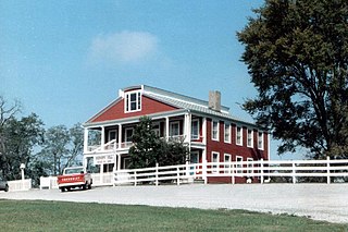
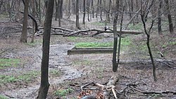
The Crenshaw House is an historic former residence and alleged haunted house located in Equality Township, Gallatin County, Illinois. The house was constructed in the 1830s. It was the main residence of John Crenshaw, his wife, and their five children.

John Hart Crenshaw was an American landowner, salt maker, kidnapper and slave trader, based out of Gallatin County, Illinois.

The pre-American Civil War practice of kidnapping into slavery in the United States occurred in both free and slave states, and both fugitive slaves and free negroes were transported to slave markets and sold, often multiple times. There were also rewards for the return of fugitives. Three types of kidnapping methods were employed: physical abduction, inveiglement of free blacks, and apprehension of fugitives. The enslavement, or re-enslavement, of free blacks occurred for 85 years, from 1780 to 1865.

This is a list of the National Register of Historic Places listings in Gallatin County, Illinois.

The Duffy site is a substantial archaeological site along the Wabash River in the southeastern part of the U.S. state of Illinois. Located near the village of New Haven in Gallatin County, it is the type site for the Duffy Complex, a group of similar sites on the Illinois side of the Wabash near its confluence with the Ohio River. Duffy is distinctive largely because of its pottery: the site's inhabitants typically produced ceramics of various thicknesses and comparatively few decorative elements, tempered with grog. What decorations exist are typically limited to one or two rows of simple lines or bars that have been incised or stamped on the side of the piece of pottery. Projectile points found at the site are small triangular "Mounds Stemless" points, and the inhabitants produced celts of a vaguely rectangular shape. The site is believed to have been inhabited circa AD 1000.
Isaiah Luna Potts was infamous in legend and lore for having run a 19th-century Illinois tavern known as "Potts Inn" where numerous crimes including robbery and murder were committed.

The Hubele Mounds and Village Site are an archaeological site in the southeastern part of the U.S. state of Illinois. Located near the community of Maunie in White County, the site has received recognition from the federal government because of its archaeological value. Due to the lack of recent excavations, the site's dates of habitation are debated, ranging from 400 BC in some estimates to AD 1000 in others, but all agree on the site's significance to understanding the prehistory of the region.

The Yankeetown site (12W1) is a substantial archaeological site along the Ohio River in the southwestern part of the U.S. state of Indiana. Inhabited during the prehistoric Woodland period, the site has yielded important information about Woodland-era peoples in the region, but it has been damaged by substantial erosion. Despite the damage, it has been a historic site for more than thirty years.

Slavery in what became the U.S. state of Illinois existed for more than a century. Illinois did not become a state until 1818, but earlier regional systems of government had already established slavery. France introduced African slavery to the Illinois Country in the early eighteenth century. French and other inhabitants of Illinois continued the practice of owning slaves throughout the Illinois Country's period of British rule (1763–1783), as well as after its transfer to the new United States in 1783 as Illinois County, Virginia. The Northwest Ordinance (1787) banned slavery in Illinois and the rest of the Northwest Territory. Nonetheless, slavery remained a contentious issue, through the period when Illinois was part of the Indiana Territory and the Illinois Territory and some slaves remained in bondage after statehood until their gradual emancipation by the Illinois Supreme Court. Thus the history of slavery in Illinois covers several sometimes overlapping periods: French ; British ; Virginia ; United States Northwest Territory (1787–1800), Indiana Territory (1800–1809), Illinois Territory (1809–1818) and the State of Illinois.

The First Illinois Constitutional Convention was held in August 1818 as a precondition for Illinois statehood. The 33 delegates elected from Illinois' 15 counties met in a tavern in Kaskaskia, the territorial capital on the first Monday in August 1818. Before the month was out, they had produced the Illinois Constitution of 1818. The convention's work paved the way for statehood and governed the law of Illinois for the state's first 30 years.