Sleeping Bear Dunes National Lakeshore is a U.S. national lakeshore in the northwestern Lower Peninsula of Michigan. Located within Benzie and Leelanau counties, the park extends along a 35-mile (56 km) stretch of Lake Michigan's eastern coastline, as well as North and South Manitou islands, preserving a total of 71,199 acres. The park is known for its outstanding natural features, including dune formations, forests, beaches, and ancient glacial phenomena. The lakeshore also contains many cultural features, including the 1871 South Manitou Island Lighthouse, three former stations of the Coast Guard, and an extensive rural historic farm district.

The Chilkoot Trail is a 33-mile (53 km) trail through the Coast Mountains that leads from Dyea, Alaska, in the United States, to Bennett, British Columbia, in Canada. It was a major access route from the coast to Yukon goldfields in the late 1890s. The trail became obsolete in 1899 when a railway was built from Dyea's neighbor port Skagway along the parallel White Pass trail.

The Applegate Trail was an emigrant trail through the present-day U.S. states of Idaho, Nevada, California, and Oregon used in the mid-19th century by emigrants on the American frontier. It was originally intended as a less dangerous alternative to the Oregon Trail by which to reach the Oregon Territory. Much of the route was coterminous with the California Trail.

Lolo National Forest is a national forest located in western Montana, United States with the western boundary being the state of Idaho. The forest spans 2 million acres (8,000 km2) and includes four wilderness areas; the Scapegoat and the Selway-Bitterroot Wilderness are partially within the forest while the Welcome Creek and Rattlesnake Wildernesses are solely in Lolo National Forest. The forest was created in 1906 from 4 different previous forests which were combined for administrative purposes. Lolo National Forest is west of the Continental divide and has a biodiversity influenced by both continental and maritime weather creating a transitional forest that has a high number of different plant and tree species.

Cumberland Mountain State Park is a state park in Cumberland County, Tennessee, in the southeastern United States. The park consists of 1,720 acres (7.0 km2) situated around Byrd Lake, a man-made lake created by the impoundment of Byrd Creek in the 1930s. The park is set amidst an environmental microcosm of the Cumberland Plateau and provides numerous recreational activities, including an 18-hole Bear Trace golf course.

This is a directory of properties and districts listed on the National Register of Historic Places in Utah, USA. There are more than 1,800 listed properties in Utah. Each of the 29 counties in Utah has at least two listings on the National Register.
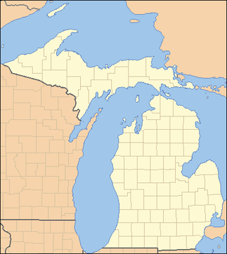
This is a list of properties on the National Register of Historic Places in the U.S. state of Michigan.
This National Park Service list is complete through NPS recent listings posted February 9, 2024.
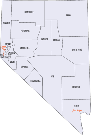
This is a list of properties and historic districts in Nevada that are listed on the National Register of Historic Places. There is at least one listing in each of Nevada's 16 counties and one independent city.

The Lariat Loop National Scenic and Historic Byway is a National Scenic Byway and a Colorado Scenic and Historic Byway located in Jefferson County, Colorado, USA. The byway is a 40-mile (64 km) loop in the Front Range foothills west of Denver through Golden, Lookout Mountain Park, Genesee Park, Evergreen, Morrison, Red Rocks Park, and Dinosaur Ridge. The Lariat Loop connects to the Mount Evans Scenic Byway at Bergen Park.

The Chicago Portage National Historic Site is a National Historic Site commemorating the importance of the Chicago Portage in Lyons, Cook County, Illinois, United States. It is located in Chicago Portage Forest Preserve and the Ottawa Trail Woods Forest Preserve, at the junction of Portage Creek with the Des Plaines River, on the west side of Harlem Avenue on the line of 48th Street. Preserved within the park is the western end of the historic portage linking the Chicago River to the Des Plaines River, thereby linking the Great Lakes to the Mississippi River. A memorial depicting the portage of French explorers is located at the parking area. A trail leads from the memorial down into the portage wilderness area.
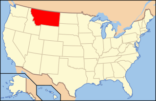
The following is an alphabetical list of articles related to the U.S. state of Montana.

The Flattop Mountain Trail, also known as the Grand Trail or the Big Trail, was built in 1925 in Rocky Mountain National Park in the Larimer County portion of the U.S. state of Colorado. Built in 1925, and rehabilitated in 1940 with Civilian Conservation Corps labor, it is listed on the National Register of Historic Places. The trail begins at 9500 feet of elevation at Bear Lake and climbs Flattop Mountain to a maximum elevation of 12,324 feet on the Continental Divide.

This is a list of the National Register of Historic Places listings in Larimer County, Colorado.

This is a list of the National Register of Historic Places listings in Bear Lake County, Idaho.
This is a complete list of the properties and districts on the National Register of Historic Places in Rocky Mountain National Park, Colorado, United States. The locations of National Register properties and districts for which the latitude and longitude coordinates are included below, may be seen in a map.
The Holzwarth Historic District comprises a series of cabins built by the Holzwarth family as a guest ranch inholding within the boundaries of Rocky Mountain National Park, at Grand Lake, Colorado. The Holzwarths made their homestead in the Kawuneeche Valley in 1917, two years after the establishment of the park, and received a patent on the homestead in 1923. Guest ranch use began in 1919 and continued until the ranch was purchased by The Nature Conservancy in 1974. The property was transferred to the National Park Service in 1975 for incorporation into the park. The district comprises a number of rustic cabins on the Colorado River. Operations existed on both sides of the river, first known as the Holzwarth Trout Ranch and later as the Never Summer Ranch. All but Joe Fleshut's cabin have been removed from the east side of the river.
Architects of the National Park Service are the architects and landscape architects who were employed by the National Park Service (NPS) starting in 1918 to design buildings, structures, roads, trails and other features in the United States National Parks. Many of their works are listed on the National Register of Historic Places, and a number have also been designated as National Historic Landmarks.

The Lake Haiyaha Trail is a historic hiking trail in Rocky Mountain National Park near Estes Park, Colorado. The trail is also known as, or subsumes, Nymph Lake Trail and Dream Lake Trail. It goes from Bear Lake up past Nymph Lake, then past Dream Lake, up to Lake Haiyaha.

The King's Highway Historic District covers the portions of U.S. Route 206 and New Jersey Route 27 in New Jersey that connect Lawrenceville with Kingston through Princeton. This historic roadway dates to colonial times and was a portion of the King's Highway that was laid out by order of Charles II of England to connect Boston with Charleston. It is lined with many institutions and sites that have played an important role in the History of the United States, including Princeton University and the Princeton Theological Seminary.
Mini-Wakan State Park is located north of Spirit Lake, Iowa, United States. The 20-acre (8.1 ha) park is along the north shore of Big Spirit Lake. It provides space for picnicking, hiking, biking, swimming, boating and fishing on the lake. The park is connected to the Dickinson County trail system in Iowa and the Jackson County trail system in Minnesota. It was listed as a historic district on the National Register of Historic Places in 2010.