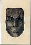
Pelican Island National Wildlife Refuge is a United States National Wildlife Refuge (NWR), and part of the Everglades Headwaters NWR complex, located just off the western coast of North Hutchinson Island in the Indian River Lagoon east of Sebastian, Florida. The refuge consists of a 3-acre (12,000 m2) island that includes an additional 2.5 acres (10,000 m2) of surrounding water and is located off the east coast of Florida of the Indian River Lagoon. Established by an executive order of President Theodore Roosevelt on March 14, 1903, Pelican Island was the first National wildlife refuge in the United States. It was created to protect egrets and other birds from extinction through plume hunting. The oldest government wildlife refuge of any kind in North America is the Lake Merritt Bird Refuge in Oakland, California. Oakland Mayor Samuel Merritt declared it a wildlife refuge for migrating birds in 1869. In 1870, the state of California designated Lake Merritt a state game refuge.
Merritt Island National Wildlife Refuge is a 140,000-acre (57,000 ha) U.S. National Wildlife Refuge (NWR) on the Atlantic coast of Florida's largest barrier island. NASA's Kennedy Space Center and visitor complex are also situated on the island and NASA can restrict access to the refuge based on its operational needs.

This is a list of properties and districts in Illinois that are on the National Register of Historic Places. There are over 1,900 in total. Of these, 85 are National Historic Landmarks. There are listings in all of the state's 102 counties.
This National Park Service list is complete through NPS recent listings posted February 9, 2024.

Egmont Key National Wildlife Refuge and State Park is a National Wildlife Refuge and State Park located on the island of Egmont Key, at the mouth of Tampa Bay. Egmont Key lies southwest of Fort De Soto Park and can only be reached by boat or ferry. Located within Egmont Key National Wildlife Refuge and State Park are the 1858 Egmont Key Lighthouse, maintained by the U.S. Coast Guard, and the ruins of Fort Dade, a Spanish–American War era fort that housed 300 residents. Egmont Key is located in Hillsborough County Florida on a narrow strip of the county that extends along the Tampa Port Shipping Channel.

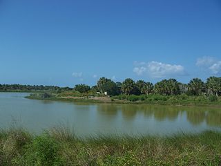
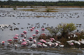
The Lake Woodruff National Wildlife Refuge is part of the United States National Wildlife Refuge System, located in north central Florida, twenty-five miles west of Daytona Beach, off U.S. Highway 17 in DeLeon Springs.
Sandy Point National Wildlife Refuge preserves habitat for threatened and endangered species, with particular emphasis on the leatherback sea turtle. Its two miles (3 km) of sandy beaches on the southwest corner of Saint Croix, U.S. Virgin Islands is an ideal nesting place for leatherbacks. The National Wildlife Refuge is open to the public for limited hours on Saturdays and Sundays.
Big Mound City (8PB48) is a prehistoric site near Canal Point, Florida, United States. It is located 10 miles east of Canal Point, off U.S. Route 98. On May 24, 1973, it was added to the U.S. National Register of Historic Places. It is located inside the J.W. Corbett Wildlife Management Area.

The Bowers Bluff Middens Archeological District is a U.S. historic district located approximately five miles southeast of Astor, Florida.
The Burns Lake Site is a historic site in Ochopee, Florida. It is located three miles west of Ochopee on U.S. 41. On May 27, 1986, it was added to the U.S. National Register of Historic Places.
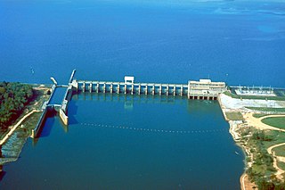
Lake Seminole is a reservoir located in the southwest corner of Georgia along its border with Florida, maintained by the U.S. Army Corps of Engineers. The Chattahoochee and Flint rivers join in the lake, before flowing from the Jim Woodruff Lock and Dam, which impounds the lake, as the Apalachicola River. The lake contains 37,500 acres (152 km2) of water, and has a shoreline of 376 mi (605 km). The fish in Lake Seminole include largemouth bass, crappie, chain pickerel, catfish, striped bass and other species. American alligators, snakes and various waterfowl are also present in the lake, which is known for its goose hunting.

The Lake George State Forest is a designated protected area and state forest in the U.S. state of Florida. The 21,176-acre (8,570 ha) forest is located in northwestern Volusia County, Florida, near Lake George and the communities of Pierson, Barberville, and Volusia. It is overseen by the Florida Forest Service within the Florida Department of Agriculture and Consumer Services.
The Emiquon National Wildlife Refuge is a 11,122-acre (45.01 km2) wetland wildlife refuge located in Waterford Township in Fulton County, Illinois across the Illinois River from the town of Havana. Only 3,000 acres (12 km2) are currently managed by the U.S. Fish and Wildlife Service as part of the Illinois River National Wildlife and Fish Refuges Complex. It is in the Central forest-grasslands transition ecoregion.

Foster Cove Archeological Site, designated RI-CH-2 and later RI-16 in state surveys, is a prehistoric archaeological site in Charlestown, Rhode Island. Located within the Ninigret National Wildlife Refuge, it is a Native American habitation site dating to the Woodland Period. It was identified in 1974 during a survey of the former Naval Auxiliary Air Station Charlestown by state archaeologists, in which two trenches included finds from the site. Test pits were dug in 1979 by the state to determine the extent of the site.

This is a list of the National Register of Historic Places listings in Ashtabula County, Ohio.

Archeological Sites at Kawela are a number of archeological sites at or near the settlement of Kawela on the southern coast of Molokaʻi, the northernmost of the islands of Maui County, Hawaii. It was the site of two battles in Hawaiian history.
The Mattamuskeet National Wildlife Refuge is a federally protected wildlife refuge located within Hyde County, North Carolina, United States. North Carolina's largest natural lake, Lake Mattamuskeet, is located entirely within the National Wildlife Refuge. The refuge has a total area of 50,173 acres (203.04 km2).

The North Maumee Bay Archeological District is a historic district containing archeological sites located in the southeasternmost corner of Erie Township in Monroe County, Michigan. It was added to the National Register of Historic Places on December 5, 1980.

Cranberry Creek Archeological District, also known as Cranberry Creek Mound Group, is an ancient American Indian burial mound site from circa AD 100–800 near New Miner, Wisconsin, United States. It is three miles east of Necedah National Wildlife Refuge in Juneau County. It is part of the "effigy mound culture" of native peoples in Wisconsin, who practiced the "respectful burial of their dead".

Hirundo Wildlife Refuge is a wildlife refuge covering 2,402 acres (972 ha) along Pushaw and Dead streams in Penobscot County, Maine. The refuge was founded in 1965 by Oliver Larouche from his parents' 3 acres (1.2 ha) camp. The refuge was donated as a trust to the University of Maine in 1983 by Larouche and his wife, June. The refuge is a living laboratory where current and past scientific research has been conducted. Hirundo is just downstream of Pushaw Lake and includes part of the Caribou Bog wetland complex, which is one of the largest wetlands in Maine. The refuge is also the site of the National Register-listed Hirundo Site, a prehistoric Native American habitation site with evidence of 4,500 years of occupation.
The Munsungan-Chase Lake Thoroughfare Archeological District encompasses a series of important archaeological sites in a remote area of northern Maine, United States. These sites offer evidence of human habitation dating to not long after the retreat of the glaciers following the Wisconsin glaciation, with extensive stone tool workshops working with red chert found in abundance in the area. Stone tools made from sources in this region have been found at archaeological sites across New England. The district was listed on the National Register of Historic Places in 1979.