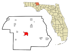
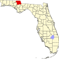
Marianna is a city in and the county seat of Jackson County, Florida, United States,[4] and it is home to Chipola College, part of the state's public system. The official nickname of Marianna is "The City of Southern Charm". The population was 6,245 at the 2020 census.
Marianna was founded in 1828 by Scottish entrepreneur Scott Beveridge (2010 source) aka Beverege, who named the town after his daughters Mary and Anna.[5]:442 The following year, it was designated as the county seat. It attracted businesses from the former sear, Webbville, which became defunct.[citation needed] Marianna was platted along the Chipola River.
Many planters from North Carolina relocated to Jackson County to develop new plantations to take advantage of the fertile soil. They relied on the labor of enslaved African Americans brought from the Upper South in the domestic slave trade.
Civil War era
Governor John Milton, a major planter who owned the Sylvania Plantation and hundreds of slaves, was a grandson of Revolutionary War hero John Millton, and a descendant of Sir Christopher Milton, the brother of the famous English poet, John Milton. A Marianna resident, he was elected as governor of Florida, serving during the Civil War years. Governor Milton opposed the Confederate States of America rejoining the United States.
As federal troops were preparing to take control of Tallahassee, Governor Milton received word that the Civil War had ended and that Florida would again be part of the United States. On April 1, 1865, as the Southern cause was collapsing, Milton was found dead of a gunshot wound at Sylvania. The New York Times reported that Governor Milton had committed suicide, noting that he had said he "would rather die" than suffer Federal invasion.[6] The West Florida News, by contrast, reported the sudden death of Florida's fifth Governor as a hunting accident.[7] Governor Milton was buried in the St. Luke's Episcopal churchyard at Marianna. During Reconstruction, the Times account dominated.
Marianna was the site of a Civil War battle in 1864 between a small home guard of about 150 boys, older men, and wounded soldiers, and a contingent of approximately 700 Federal troops.
Reconstruction period
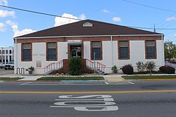
Historic Abstract Office, Downtown Marianna
During the early years after the Civil War, Ku Klux Klan terrorism and violence flared in Marianna, Florida, and surrounding Jackson County. Disputes over farm land prompted much of the Klan activity, as white supremacists violently reacted against black freedmen gaining ownership of tax-forfeited farms [5]:443—which was new federal law of the Reconstruction era. Local leaders of the Klan committed to restoring white supremacy throughout Jackson County; they enforced their mandate by perpetrating terror and intimidation against local blacks and their white sympathizers/agents.[8]:548–550 In a sustained campaign of terrorism known as the Jackson County War an estimated 150 to 200 Republicans, many black, were murdered or maimed in violent beatings by nightriding mobs of Klansmen.[9][10] Local white officials typically claimed—without offering evidence—that the violence was the work of carpetbaggers and "ruffians" from the border states. Bishop Charles H. Pearce of Massachusetts, an AME minister who became a state senator in Florida, had first-hand knowledge of the situation. He blamed the planters of Jackson County, who publicly advocated for deadly violence against black Republicans.
Post-Reconstruction to mid-20th century
Dekle-Brunner House, Marianna Historic District
Violence continued in the state after Reconstruction, reaching a peak in most areas at the turn of the 20th century. This was the period in which southern states also disenfranchised most blacks and thousands of poor whites by raising barriers to voter registration. From 1900 to 1930, Florida had the highest rate of lynchings per capita in the South and the nation. Refusing to accept the violence, thousands of African Americans left the state during the Great Migration of the early 20th century, going to northern and midwestern industrial cities for work and other opportunities.
Historic Chipola Hotel, Downtown Marianna
Lynchings in Marianna
In 1934 Claude Neal, a local African-American man, was accused of the rape and murder of a young white woman. He was moved between jails, but a lynch mob found him in Brewton, Alabama. The mob abducted him and brought him back to Florida, killing him near the Chattahoochee River and Greenwood. The men brought his body to the Cannady farm, where a larger mob of an estimated 2,000 persons was waiting; people shot and mutilated the body. Neal's body was hanged from a tree at the Marianna courthouse square.
The next day, whites rioted in town, attacking blacks and destroying some of their houses. The governor ordered more than 100 troops of the National Guard to Marianna to suppress the violence. About 200 blacks and two police were injured. The six white vigilantes who led the lynching remain unidentified.
In 1943 Cellos Harrison was taken from the county jail at Marianna by a white mob and hanged (lynched) near Greenwood. His case had been in the courts for two years in appeals after the African-American man was arrested and twice convicted by all-white juries and sentenced to death for the 1940 murder of a white man. He had confessed without benefit of counsel, and his convictions were overturned by the Florida Supreme Court as a result. But whites were tired of waiting for the case to be resolved, and lynched him.
President Franklin D. Roosevelt directed the Department of Justice to investigate Harrison's lynching; he felt it was unjust that blacks were getting lynched at home while the U.S. was ostensibly fighting for freedom in Europe. No one was ever prosecuted for Harrison's death.[11][pageneeded]
The Florida School for Boys, a large state reform school, operated in Marianna from January 1, 1900, to June 30, 2011. For a time, it was the largest juvenile reform institution in the United States. Throughout its 111-year history, the school gained a reputation for abuse, beatings, rapes, and torture of students by staff. It was rumored that students had died there as a result of injuries. Despite periodic investigations, changes of leadership, and promises by the state to improve conditions, the allegations of cruelty and abuse continued.
Many of the allegations were confirmed by separate investigations by the Florida Department of Law Enforcement in 2010 and the Civil Rights Division of the United States Department of Justice in 2011. State authorities closed the school permanently in June 2011.
In 2015, a multi-year investigation of the cemetery and grounds by the University of South Florida (USF), which was attempting to find undocumented burials on the grounds, revealed details of a secret "rape dungeon", where boys younger than 12 were sexually abused. It positively identified five bodies from remains recovered on the grounds.[12] By January 2016, the end of the USF's studies of the grounds and exhumation of remains, it had identified 55 previously unknown burials, made a match for seven bodies through DNA, and presumptively identified another 14 sets of remains of 51 found. Twenty-seven more graves were discovered in 2019.[13] The team created a website containing documentation of their investigation and will continue to work with state agencies and families of former students to identify more remains.
Hurricane Michael
The city was one of several Florida Panhandle communities devastated by Category 5 Hurricane Michael on October 10, 2018.[14] The downtown area was strongly hit: several historic buildings collapsed and blocked Lafayette Street, which is the main road.
The city was without power for three weeks, which caused extensive school cancellations. More than 80% of homes and businesses in Marianna were heavily damaged or destroyed due to Michael's extreme winds. Millions of dollars in insurance claims were filed, and the area suffered millions of dollars in economic losses. This hurricane is the worst natural disaster to ever strike Marianna, surpassing the damages caused by a F-3 tornado spawned by Hurricane Ivan in September 2004.
Geography
Marianna is located in central Jackson County. U.S. Route 90 passes through the center of town as Lafayette Street, leading east 14 miles (23km) to Grand Ridge and west 9 miles (14km) to Cottondale. Interstate 10 passes through the southern end of the city, leading east 65 miles (105km) to Tallahassee, the state capital, and west 130 miles (210km) to Pensacola. Access to Marianna is at Exit 136, Florida State Road 276. It is close to the time zone border
According to the United States Census Bureau, the city has a total area of 16.8 square miles (43.6km2), of which 0.04 square miles (0.1km2), or 0.29%, are water.[15] The Chipola River, which forms the eastern border of the city, is part of the Apalachicola River watershed.
Climate
Climate data for Marianna, Florida (Marianna Municipal Airport), 1991–2020 normals, extremes 1950–present
As of the 2020 United States census, there were 6,245 people, 2,908 households, and 1,662 families residing in the city.[22]
As of the 2010 United States census, there were 6,102 people, 1,924 households, and 1,189 families residing in the city.[23]
2000 census
As of the census[3] of 2000, there were 6,230 people, 2,398 households, and 1,395 families residing in the city. The population density was 776.1 inhabitants per square mile (299.7/km2). There were 2,764 housing units at an average density of 344.3 per square mile (132.9/km2). The racial makeup of the city was 56.8% White, 40.2% African American, 0.3% Native American, 0.7% Asian, 0.9% from other races, and 1.1% from two or more races. Hispanic or Latino of any race were 2.6% of the population.
In 2000, there were 2,398 households, out of which 28.8% had children under the age of 18 living with them, 34.3% were married couples living together, 20.7% had a female householder with no husband present, and 41.8% were non-families. 38.0% of all households were made up of individuals, and 19.3% had someone living alone who was 65 years of age or older. The average household size was 2.22 and the average family size was 2.96.
In 2000, in the city, the population was spread out, with 26.7% under the age of 18, 11.8% from 18 to 24, 22.3% from 25 to 44, 18.4% from 45 to 64, and 20.8% who were 65 years of age or older. The median age was 36 years. For every 100 females, there were 88.9 males. For every 100 females age 18 and over, there were 76.7 males.
In 2000, the median income for a household in the city was $23,861, and the median income for a family was $29,590. Males had a median income of $28,500 versus $21,530 for females. The per capita income for the city was $14,021. About 20.9% of families and 28.5% of the population were below the poverty line, including 41.7% of those under age 18 and 34.6% of those age 65 or over.
Education
Jackson County School Board operates public K–12 schools. Marianna has four schools, all of which usually perform in the high C-low B range in the state's FCAT grade scale. Marianna K-8 School for grades Pre-K to 8th grade, and Marianna High School for grades 9–12, Jackson Alternative School for grades 4-12, and Hope School for grades PK-12.
Freight service is provided by the Florida Gulf & Atlantic Railroad, which acquired most of the former CSX main line from Pensacola to Jacksonville on June 1, 2019.
Marianna is an official Florida Main Street town. The downtown area has been restored to look as it did many years ago, to encourage heritage tourism and emphasize its unique character and a pedestrian-friendly neighborhood. The downtown area includes the Marianna Historic District, which has a number of antebellum homes.
↑Cox, Dale (2010). The History of Jackson County, Florida: The Civil War Years. Two Egg, FL: CreateSpace Independent Publishing Platform. p.191. ISBN978-1448685141.
↑Wasserman, Adam (2010). A People's History of Florida 1513–1876. How Africans, Seminoles, Women, and Lower Class Whites Shaped the Sunshine State (4thed.). Sarasota, Florida. ISBN9781442167094.{{cite book}}: CS1 maint: location missing publisher (link)
↑Newton 2001, pp. 1–30. Newton quotes from the Testimony Taken by the Joint Select Committee to Enquire into the Condition of Affairs in the Late Insurrectionary States, Vol. 13. Washington, D.C.: U.S. Government Printing Office, 1872. Among historians of the Klan, this volume is also known as The KKK testimony.
↑Newton, Michael (2001). The Invisible Empire: The Ku Klux Klan in Florida. University Press of Florida. ISBN 978-0813021201. Archived from the original on April 8, 2023. Retrieved November 17, 2021.
↑Tameka Bradley Hobbs, Democracy Abroad, Lynching at Home: Racial Violence in Florida, Oxford University Press, 2015
This page is based on this Wikipedia article Text is available under the CC BY-SA 4.0 license; additional terms may apply. Images, videos and audio are available under their respective licenses.