Bushnell, Florida

Last updated

Bushnell, Florida
City of Bushnell
Bushnell Sumter Cty Crths01.jpg
Old Sumter County Courthouse
Motto: 
"Committed to the Quality of Life"
Sumter County Florida Incorporated and Unincorporated areas Bushnell Highlighted.svg
Location in Sumter County and the state of Florida
Coordinates: 28°39′54″N82°06′46″W / 28.66500°N 82.11278°W / 28.66500; -82.11278 [1]
Country Flag of the United States.svg  United States
State Flag of Florida.svg  Florida
County   Sumter
Incorporated 1911
Government
  Type Council–Manager
   Mayor Jessie Simmons, Jr.
   Vice Mayor Lance Lowery
   Council Members Karen Davis, Dale Swain,
and Marge Thies
   City Manager Michael Eastburn
   City Clerk Christina Dixon
Area
[2]
  Total12.70 sq mi (32.90 km2)
  Land12.42 sq mi (32.16 km2)
  Water0.29 sq mi (0.74 km2)
Elevation
[1]
75 ft (23 m)
Population
 (2020)
  Total3,047
  Density245.41/sq mi (94.76/km2)
Time zone UTC-5 (Eastern (EST))
  Summer (DST) UTC-4 (EDT)
ZIP code
33513
Area code 352
FIPS code 12-09625 [3]
Website cityofbushnellfl.com

Bushnell is a city in western Florida and is the county seat of Sumter County, Florida, United States. The population was 3,047 at the 2020 census.

Contents

History

A post office called Bushnell has been in operation since 1885. [4] The City of Bushnell was named after John W. Bushnell, who was responsible for bringing the railroad to the community. [5] The City of Bushnell is also home to Dade Battlefield Historic State Park, a park where on December 28, 1835, Seminoles ambushed 107 men in the forested area. Only 3 survivors came out of Dade Battlefield, and the battle signaled the beginning of the Second Seminole War.

Geography

The exact coordinates for the City of Bushnell is located at 28°39′54″N82°06′46″W / 28.66500°N 82.11278°W / 28.66500; -82.11278 .

Bushnell is located in west-central Sumter County. The area around Bushnell is relatively flat, with some forested areas belonging to the state and rivers, creeks, and small streams that flow underneath roadways with bridges.

Climate

The City of Bushnell is part of the humid subtropical climate zone with a Köppen Climate Classification of "Cfa" (C = mild temperate, f = fully humid, and a = hot summer).

Demographics

Historical population
CensusPop.Note
1920 400
1930 59147.8%
1940 67614.4%
1950 536−20.7%
1960 64420.1%
1970 7008.7%
1980 98340.4%
1990 1,998103.3%
2000 2,0502.6%
2010 2,41818.0%
2020 3,04726.0%
U.S. Decennial Census [6]

2010 and 2020 census

Bushnell racial composition
(Hispanics excluded from racial categories)
(NH = Non-Hispanic)
RacePop 2010 [7] Pop 2020 [8] % 2010% 2020
White (NH)1,8402,19476.10%72.01%
Black or African American (NH)30434312.57%11.26%
Native American or Alaska Native (NH)16170.66%0.56%
Asian (NH)12190.50%0.62%
Pacific Islander or Native Hawaiian (NH)060.00%0.20%
Some other race (NH)7180.29%0.59%
Two or more races/Multiracial (NH)441191.82%3.91%
Hispanic or Latino (any race)1953318.06%10.86%
Total2,4183,047

As of the 2020 United States census, there were 3,047 people, 1,137 households, and 776 families residing in the city. [9]

As of the 2010 United States census, there were 2,418 people, 1,400 households, and 906 families residing in the city. [10]

2000 census

At the 2000 census there were 2,050 people in 830 households, including 538 families, in the city. The population density was 871.7 inhabitants per square mile (336.6/km2). There were 1,004 housing units at an average density of 426.9 per square mile (164.8/km2). The racial makeup of the city was 83.37% White, 12.98% African American, 0.34% Native American, 0.73% Asian, 1.27% from other races, and 1.32% from two or more races. Hispanic or Latino of any race were 3.56%. [3]

Of the 830 households in 2000, 25.4% had children under the age of 18 living with them, 49.4% were married couples living together, 12.4% had a female householder with no husband present, and 35.1% were non-families. 31.2% of households were one person and 17.7% were one person aged 65 or older. The average household size was 2.25 and the average family size was 2.79.

In 2000, the age distribution was 20.6% under the age of 18, 8.8% from 18 to 24, 23.3% from 25 to 44, 21.5% from 45 to 64, and 25.8% 65 or older. The median age was 43 years. For every 100 females, there were 90.2 males. For every 100 females age 18 and over, there were 85.4 males.

In 2000, the median household income was $26,676 and the median family income was $34,063. Males had a median income of $27,986 versus $23,125 for females. The per capita income for the city was $14,737. About 11.0% of families and 14.7% of the population were below the poverty line, including 17.5% of those under age 18 and 13.4% of those age 65 or over.

Government and infrastructure

Sumter County operates Bushnell Annex in Room 201 at 910 North Main Street. [11]

Transportation

The main roads through Bushnell include US 301 which runs north and south through the city. County Road 48 (SR 48 until 2016) and County Road 476 run east and west, and have short concurrency with US 301, as well as each other.

Interstate 75 runs along the western edge of Bushnell with Exit 314 leading to Sumter CR 48. County Road 475 begins at CR 48 and runs the CSX Wildwood Subdivision, which carried Amtrak's Palmetto until 2004. [12] The Wildwood Subdivision runs along US 301 from north of the Hernando-Sumter County Line, to Bushnell until Route 301 turns onto East Noble Avenue. From there it runs along the east side of CR 48 until that route turns west onto West Belt Avenue, then follows the east side of CR 475 until its terminus at Exit 321 on I-75 at CR 470 in Lake Panasoffkee.

Bushnell also runs a small transit bus, that follows a daily route around the city's main attractions and busiest areas.

Education

Sumter District Schools headquarters and South Sumter High School are located in Bushnell.

Related Research Articles

<span class="mw-page-title-main">Sumter County, Florida</span> County in Florida, United States

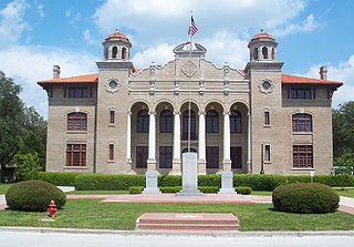
Sumter County is a county located in the central portion of the U.S. state of Florida. As of the 2020 census, the population is 129,752. It has the oldest median age of any US county and the highest percentage of residents aged 65 and older—at 55.6% in 2014-2018. Its county seat is Bushnell, and the largest community is The Villages.

<span class="mw-page-title-main">Macclenny, Florida</span> City in Florida, United States

Macclenny is a city and the county seat of Baker County, Florida. Located just west of Jacksonville, it is one of the principal municipalities comprising Greater Jacksonville. The population was 7,304 at the 2020 census, up from 6,374 in 2010.

<span class="mw-page-title-main">West Melbourne, Florida</span> City in Florida

West Melbourne is a city in Brevard County, Florida, United States. It was created in 1959 to stop the area from being annexed into the city of Melbourne. Since 2000, the city has experienced the highest population growth percentage of any municipality in Brevard County. It is part of the Palm Bay–Melbourne–Titusville Metropolitan Statistical Area. As of the 2020 US Census, the population was 18,355.

<span class="mw-page-title-main">Clermont, Florida</span> City in Florida

Clermont is a city in Lake County in central Florida, United States, about 22 miles (35 km) west of Orlando and 22 miles (35 km) southeast of Leesburg. The population was 43,021 in 2020. The city is residential in character and its economy is centered in retail trade, lodging, and tourism-oriented restaurants and bars. It is part of the Orlando–Kissimmee–Sanford Metropolitan Statistical Area.

<span class="mw-page-title-main">Leesburg, Florida</span> City in Florida

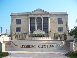
Leesburg is a city in Lake County, Florida, United States. The population was 20,117 at the 2010 census. As of 2019, the population recorded by the U.S. Census Bureau was 23,671.

<span class="mw-page-title-main">Mascotte, Florida</span> City in Florida

Mascotte is a city in Lake County, Florida, United States. As of the 2020 census, the population was 6,609, up from 5,101 in 2010. It is part of the Orlando–Kissimmee–Sanford Metropolitan Statistical Area.

<span class="mw-page-title-main">Tavares, Florida</span> City in Florida

Tavares is a city and the county seat of Lake County, Florida. The population at the 2020 census was 19,003, and in 2019 the population was estimated to be 17,749. It is part of the Orlando–Kissimmee–Sanford Metropolitan Statistical Area.

<span class="mw-page-title-main">Umatilla, Florida</span> City in Florida

Umatilla is a city in Lake County, Florida, United States. The population was 3,685 at the 2020 census. Umatilla is known as the Gateway to the Ocala National Forest, located in northern Lake County.

<span class="mw-page-title-main">North Fort Myers, Florida</span> Census-designated place in Florida, United States

North Fort Myers is an unincorporated area and census-designated place (CDP) in Lee County, Florida, United States. It is part of the Cape Coral-Fort Myers, Florida Metropolitan Statistical Area. The population was 42,719 at the 2020 census.

<span class="mw-page-title-main">Belleview, Florida</span> City in Florida, United States

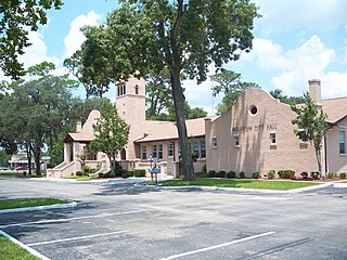
Belleview is a city in Marion County, Florida, United States. The population was 5,413 at the 2020 census, up from 4,492 in 2010. It is part of the Ocala Metropolitan Statistical Area. The city's name comes from the French words belle and vue, meaning "beautiful view". "City with Small Town Charm" is the city's motto.

<span class="mw-page-title-main">Country Club, Florida</span> Census-designated place in Florida

Country Club is a census-designated place and a suburban unincorporated community located in northwest Miami-Dade County, Florida, United States. It is located in the Miami metropolitan area of South Florida. The CDP is named after the Country Club of Miami, which was established in 1961 in what was then an unpopulated and undeveloped section of the county. The population was 49,967 at the 2020 census, up from 3,408 in 1990.

<span class="mw-page-title-main">Homestead Base, Florida</span> Census-designated place in Florida

Homestead Base is a census-designated place (CDP) in Miami-Dade County, Florida, United States. The CDP comprises the extent of Homestead Air Reserve Base plus some surrounding land. It is part of the Miami metropolitan area of South Florida. The population was 999 at the 2020 census.

<span class="mw-page-title-main">Leisure City, Florida</span> Census-designated place in Florida

Leisure City is an unincorporated community and census-designated place (CDP) in Miami-Dade County, Florida, United States, that includes the smaller, older community of Modello in its northwestern section. The CDP is most notable for the Coral Castle Museum, located in the Modello area. It is located in the Miami metropolitan area of South Florida. The population was 26,324 at the 2020 census, up from 22,655 in 2010.

<span class="mw-page-title-main">Palmetto Estates, Florida</span> Census-designated place in Florida

Palmetto Estates is an unincorporated area and census-designated place (CDP) in Miami-Dade County, Florida, United States. It is part of the Miami metropolitan area of South Florida. The population was 13,498 at the 2020 census.

<span class="mw-page-title-main">Land o' Lakes, Florida</span> Census-designated place in Florida, United States

Land O' Lakes is a census-designated place (CDP) in Pasco County, Florida, United States. It is part of the Tampa-St. Petersburg-Clearwater, Florida MSA. As of the 2020 US census, the CDP had a population of 35,929.

<span class="mw-page-title-main">Zephyrhills, Florida</span> City in Florida, United States of America

Zephyrhills is a city in Pasco County, Florida, United States. The population was counted at 17,194 in the 2020 census. The city is the headquarters of the Zephyrhills bottled water company. The current mayor is Melonie Monson.

<span class="mw-page-title-main">Wildwood, Florida</span> City in Florida, United States

Wildwood is a city in Sumter County, Florida, United States. The population was 15,730 at the 2020 census.

<span class="mw-page-title-main">Edgewater, Volusia County, Florida</span> City in Florida

Edgewater is a city in Volusia County, Florida, United States, situated along the Indian River North, adjacent to the Mosquito Lagoon. It is a part of the Deltona–Daytona Beach–Ormond Beach, FL metropolitan statistical area. As of the 2020 US census, the city had a population of 23,097.

<span class="mw-page-title-main">Freeport, Florida</span> City in Florida, United States of America

Freeport is a city in Walton County, Florida, United States. It is part of the Crestview–Fort Walton Beach–Destin metropolitan area. As of the 2020, the population recorded by the U.S. Census Bureau was 5,861.

<span class="mw-page-title-main">Sun City Center, Florida</span> Census-designated place in Florida, United States

Sun City Center is an unincorporated census-designated place (CDP) in southern Hillsborough County, Florida, United States. It is located south of Tampa and north of Sarasota on I-75. As of the 2020 census, the population was 30,952. The ZIP Code serving the community is 33573.

References

  1. 1 2
  2. "2020 U.S. Gazetteer Files". United States Census Bureau. Retrieved October 31, 2021.
  3. 1 2 "U.S. Census website". United States Census Bureau . Retrieved January 31, 2008.
  4. "Post Offices, Florida, Sumter County". Jim Forte Postal History.
  5. Blackstone, Lillian (March 23, 1952). "Into center of state". St. Petersburg Times. p. 19. Retrieved November 1, 2015.
  6. "Census of Population and Housing". Census.gov. Retrieved June 4, 2015.
  7. "P2 HISPANIC OR LATINO, AND NOT HISPANIC OR LATINO BY RACE - 2010: DEC Redistricting Data (PL 94-171) - Bushnell city, Florida". United States Census Bureau .
  8. "P2 HISPANIC OR LATINO, AND NOT HISPANIC OR LATINO BY RACE - 2020: DEC Redistricting Data (PL 94-171) - Bushnell city, Florida". United States Census Bureau .
  9. "S1101 HOUSEHOLDS AND FAMILIES - 2020: Bushnell city, Florida". United States Census Bureau .
  10. "S1101 HOUSEHOLDS AND FAMILIES - 2010: Bushnell city, Florida". United States Census Bureau .
  11. "Support Services Archived 2008-12-25 at the Wayback Machine ." Sumter County, Florida . Retrieved on December 11, 2008.
  12. Map of Sumter County, 1932 (University of South Florida)