Mayo, Florida | |
---|---|
Town of Mayo | |
![]() Lafayette County Courthouse | |
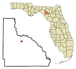
![]() Location in Lafayette County and the state of Florida | |
Coordinates: 30°3′7″N83°10′32″W / 30.05194°N 83.17556°W | |
Country | ![]() |
State | ![]() |
County | Lafayette |
Settled | 1874 [1] |
Incorporated | 1903 [1] [2] |
Government | |
• Type | Mayor-Council |
• Mayor [1] | Ann Murphy |
• Vice Mayor | Virginia McCray |
• Councilors | Wayne Hamlin, Mamie Thomas, and Jessica Lawson |
• Town Clerk | Janet Putnel |
• Town Attorney | Angela Ball |
Area | |
• Total | 0.90 sq mi (2.33 km2) |
• Land | 0.90 sq mi (2.33 km2) |
• Water | 0.00 sq mi (0.00 km2) |
Elevation | 89 ft (27 m) |
Population (2020) | |
• Total | 1,055 |
• Density | 1,173.53/sq mi (453.08/km2) |
Time zone | UTC-5 (Eastern (EST)) |
• Summer (DST) | UTC-4 (EDT) |
ZIP code | 32066 |
Area code | 386 |
FIPS code | 12-43575 [4] |
GNIS feature ID | 0286548 [5] |
Mayo, Florida is a town and the only municipality in Lafayette County, Florida, United States. It is the county seat of Lafayette County. [6] The population was 1,055 at the 2020 census.
Although the current Town of Mayo was settled and established in 1874 by John B. Whitfield, the town wasn't officially incorporated as a municipality until 1903. [1] [7] Whitfield decided to name the town after James M. Mayo, who was a colonel in the Confederate States Army. [1] [7]
An African American man named Charles Strong was lynched on January 17, 1922. [8]
In August 2018, Mayo temporarily changed the town's name to " Miracle Whip " as an advertisment publicity stunt for the Kraft Heinz brand. [9]
The approximate coordinates for the Town of Mayo is located at 30°03′07″N83°10′32″W / 30.051947°N 83.175676°W . [10]
According to the United States Census Bureau, the town has a total area of 2.1 km2 (0.81 sq mi), all land.
The climate in this area is characterized by hot, humid summers and generally mild winters. According to the Köppen climate classification, the Town of Mayo has a humid subtropical climate zone (Cfa).
Climate data for Mayo, Florida, 1991–2020 normals, extremes 1949–present | |||||||||||||
---|---|---|---|---|---|---|---|---|---|---|---|---|---|
Month | Jan | Feb | Mar | Apr | May | Jun | Jul | Aug | Sep | Oct | Nov | Dec | Year |
Record high °F (°C) | 88 (31) | 93 (34) | 92 (33) | 96 (36) | 101 (38) | 104 (40) | 103 (39) | 103 (39) | 99 (37) | 96 (36) | 92 (33) | 88 (31) | 104 (40) |
Mean maximum °F (°C) | 80.3 (26.8) | 82.7 (28.2) | 85.8 (29.9) | 89.4 (31.9) | 94.5 (34.7) | 97.1 (36.2) | 97.6 (36.4) | 96.8 (36.0) | 94.9 (34.9) | 90.6 (32.6) | 85.9 (29.9) | 81.8 (27.7) | 98.7 (37.1) |
Mean daily maximum °F (°C) | 67.7 (19.8) | 72.0 (22.2) | 77.7 (25.4) | 81.6 (27.6) | 87.8 (31.0) | 90.9 (32.7) | 91.8 (33.2) | 91.6 (33.1) | 88.8 (31.6) | 83.1 (28.4) | 76.9 (24.9) | 71.0 (21.7) | 81.7 (27.6) |
Daily mean °F (°C) | 54.5 (12.5) | 58.2 (14.6) | 63.5 (17.5) | 67.5 (19.7) | 74.7 (23.7) | 79.9 (26.6) | 81.6 (27.6) | 81.5 (27.5) | 78.2 (25.7) | 70.3 (21.3) | 63.0 (17.2) | 57.4 (14.1) | 69.2 (20.7) |
Mean daily minimum °F (°C) | 41.3 (5.2) | 44.4 (6.9) | 49.4 (9.7) | 53.3 (11.8) | 61.6 (16.4) | 68.9 (20.5) | 71.4 (21.9) | 71.4 (21.9) | 67.7 (19.8) | 57.6 (14.2) | 49.1 (9.5) | 43.8 (6.6) | 56.7 (13.7) |
Mean minimum °F (°C) | 22.2 (−5.4) | 25.3 (−3.7) | 29.9 (−1.2) | 39.2 (4.0) | 48.4 (9.1) | 60.6 (15.9) | 66.0 (18.9) | 66.2 (19.0) | 58.4 (14.7) | 40.5 (4.7) | 29.8 (−1.2) | 25.7 (−3.5) | 20.4 (−6.4) |
Record low °F (°C) | 7 (−14) | 12 (−11) | 19 (−7) | 31 (−1) | 41 (5) | 47 (8) | 58 (14) | 58 (14) | 40 (4) | 27 (−3) | 19 (−7) | 10 (−12) | 7 (−14) |
Average precipitation inches (mm) | 4.66 (118) | 3.40 (86) | 4.24 (108) | 3.09 (78) | 3.11 (79) | 7.58 (193) | 7.56 (192) | 8.11 (206) | 5.39 (137) | 3.07 (78) | 2.04 (52) | 3.33 (85) | 55.58 (1,412) |
Average precipitation days (≥ 0.01 in) | 8.3 | 7.8 | 7.4 | 6.1 | 6.6 | 13.7 | 13.8 | 15.5 | 9.9 | 5.9 | 5.4 | 7.6 | 108.0 |
Source: NOAA [11] [12] |
Census | Pop. | Note | %± |
---|---|---|---|
1910 | 578 | — | |
1920 | 531 | −8.1% | |
1930 | 555 | 4.5% | |
1940 | 915 | 64.9% | |
1950 | 679 | −25.8% | |
1960 | 687 | 1.2% | |
1970 | 793 | 15.4% | |
1980 | 891 | 12.4% | |
1990 | 917 | 2.9% | |
2000 | 988 | 7.7% | |
2010 | 1,237 | 25.2% | |
2020 | 1,055 | −14.7% | |
U.S. Decennial Census [13] |
Race | Pop 2010 [14] | Pop 2020 [15] | % 2010 | % 2020 |
---|---|---|---|---|
White (NH) | 687 | 583 | 55.54% | 55.26% |
Black or African American (NH) | 303 | 266 | 24.49% | 25.21% |
Native American or Alaska Native (NH) | 0 | 3 | 0.00% | 0.28% |
Asian (NH) | 7 | 7 | 0.57% | 0.66% |
Pacific Islander or Native Hawaiian (NH) | 0 | 1 | 0.00% | 0.09% |
Some other race (NH) | 2 | 2 | 0.16% | 0.19% |
Two or more races/Multiracial (NH) | 27 | 23 | 2.18% | 2.18% |
Hispanic or Latino (any race) | 211 | 170 | 17.06% | 16.11% |
Total | 1,237 | 1,055 | ||
As of the 2020 United States census, there were 1,055 people, 419 households, and 211 families residing in the town. [16]
As of the 2010 United States census, there were 1,237 people, 376 households, and 254 families residing in the town. [17]
As of the census [4] of 2000, there were 988 people, 338 households, and 228 families residing in the town. The population density was 1,209.1 inhabitants per square mile (466.8/km2). There were 365 housing units at an average density of 446.7 per square mile (172.5/km2). The racial makeup of the town was 61.23% White, 27.43% African American, 0.40% Native American, 0.10% Pacific Islander, 9.62% from other races, and 1.21% from two or more races. Hispanic or Latino of any race were 16.80% of the population.
In 2000, there were 338 households, out of which 33.1% had children under the age of 18 living with them, 42.3% were married couples living together, 19.2% had a female householder with no husband present, and 32.5% were non-families. 28.4% of all households were made up of individuals, and 13.3% had someone living alone who was 65 years of age or older. The average household size was 2.70 and the average family size was 3.23.
In 2000, in the town, the population was spread out, with 28.2% under the age of 18, 11.1% from 18 to 24, 24.8% from 25 to 44, 21.7% from 45 to 64, and 14.2% who were 65 years of age or older. The median age was 33 years. For every 100 females, there were 96.0 males. For every 100 females age 18 and over, there were 92.1 males.
In 2000, the median income for a household in the town was $25,398, and the median income for a family was $28,438. Males had a median income of $21,802 versus $17,697 for females. The per capita income for the town was $13,298. About 30.6% of families and 34.6% of the population were below the poverty line, including 42.5% of those under age 18 and 54.7% of those age 65 or over.
Historic buildings and structures in Mayo include: [18]
Lafayette County is a county located in the north central portion of the state of Florida. As of the 2020 census, the population was 8,226, making it the second-least populous county in Florida. The county seat is Mayo. Lafayette County is a prohibition or partially dry county, allowing retail sales of beer.
Blountstown is a city and the county seat of Calhoun County, Florida, United States. As of the 2020 census, the city had a population of 2,266.
Cross City is a town and the county seat of Dixie County, Florida, United States. The population was 1,689 at the 2020 census.
Century is a town in Escambia County, Florida, United States. Per the 2020 census, the population was 1,713, up from 1,698 at the 2010 census. It is part of the Pensacola–Ferry Pass–Brent, Florida Metropolitan Statistical Area.
Beverly Beach is a town in Flagler County, Florida, United States. The Town of Beverly Beach is part of the Deltona–Daytona Beach–Ormond Beach, FL metropolitan statistical area. The population was 474 at the 2020 census, up from 338 in the 2010 census.
Fanning Springs is a city in Gilchrist and Levy counties in the U.S. state of Florida. It is part of the Gainesville, Florida Metropolitan Statistical Area. The population was 1,182 at the 2020 census, up from 764 at the 2010 census.
Ponce de Leon is a town in Holmes County, Florida, United States. The Town of Ponce de Leon was named after Spanish explorer, Juan Ponce de León. It is part of the Florida Panhandle in North Florida. The population was 504 at the 2020 census, down from 598 at the 2010 census.
Cottondale is a city in Jackson County, Florida, United States. It is part of the Florida Panhandle and North Florida. The population was 848 at the 2020 census, down from 933 at the 2010 census.
Malone is a town in Jackson County, Florida, United States. The population was 1,959 at the 2020 census.
Minneola is a city in Lake County, Florida, United States. It is part of the Orlando–Kissimmee–Sanford Metropolitan Statistical Area. The Minneola tangelo is named after the city. The population was 13,843 at the 2020 census.
Montverde is a town in Lake County, Florida, United States. The population was 1,655 at the 2020 census. It is part of the Orlando–Kissimmee–Sanford Metropolitan Statistical Area.
Greenville is a town in Madison County, Florida, United States. The population was 746 at the 2020 census, down from 843 at the 2010 census.
Madison is a city in and the county seat of Madison County, on the central northern border of Florida, United States. The population was 2,912 at the 2020 census.
Reddick is a town in Marion County, Florida, United States. It is part of the Ocala Metropolitan Statistical Area. As of the 2020 US census, the town population was 449, down from 506 in 2010 US census.
Kenneth City is a town in southern Pinellas County, Florida, between St. Petersburg and Pinellas Park, United States. It is part of the Tampa–St. Petersburg–Clearwater Metropolitan statistical area (MSA), much more commonly known as the Tampa Bay area. The population was 5,047 at the 2020 US census.
St. Lucie Village is a town in St. Lucie County, Florida, United States. It is part of the Port St. Lucie Metropolitan Statistical Area. The population was 613 at the 2020 census.
Pierson is a town in Volusia County, Florida, United States. The town is part of the Deltona–Daytona Beach–Ormond Beach, Florida Metropolitan Statistical Area. The population was 1,542 as of the 2020 census.
Freeport is a city in Walton County, Florida, United States. It is part of the Crestview–Fort Walton Beach–Destin, Florida Metropolitan Statistical Area. As of the 2020, the population recorded by the U.S. Census Bureau was 5,861, up from 1,787 at the 2010 census. Freeport is one of the fastest growing cities in Florida. After the construction of the massive group of neighborhoods, Hammock Bay, the population grew by about 2 thousand.
Chipley is a city in and the county seat of Washington County, Florida, United States, located between Tallahassee and Pensacola. Its population was 3,660 in the 2020 census, up from 3,605 at the 2010 census. It is part of the Panama City—Panama City Beach, Florida Metropolitan Statistical Area. The area is served by Chipley High School.
Indian River Shores is a town in Indian River County, Florida, United States. As of the 2020 census, the town has a population of 4,241. Located on Orchid Island, Indian River Shores is bordered by the Atlantic Ocean to the east and the Indian River Lagoon to the west.