Jasper, Florida

Last updated

Jasper, Florida
City of Jasper
JasperFLColl14.png
Images top, left to right: Downtown Jasper, First United Methodist Church, Hamilton County Courthouse, U.S. Route 129, Old Hamilton County Jail
Motto: 
"Florida's Front Porch"
Hamilton County Florida Incorporated and Unincorporated areas Jasper Highlighted.svg
Location in Hamilton County and the state of Florida
Coordinates: 30°31′8″N82°57′4″W / 30.51889°N 82.95111°W / 30.51889; -82.95111
Country Flag of the United States.svg  United States
State Flag of Florida.svg  Florida
County   Hamilton
Settled 1827-1840s
Incorporated March 2, 1858 [1]
Named for William Jasper
Government
  Type Council-Manager
   Mayor Williams S. Mitchell, V
   Vice Mayor Carlton Garrett Selph
   Council Members Vanessa Smith,
Jhelechia Hawkins,
and Jay Daigle, III
   City Manager Mark Meyers
   City Clerk Loretta Taylor
Area
[2]
  Total2.42 sq mi (6.26 km2)
  Land2.42 sq mi (6.26 km2)
  Water0.00 sq mi (0.00 km2)
Elevation
151 ft (46 m)
Population
 (2020)
  Total3,621
  Density1,498.76/sq mi (578.66/km2)
Time zone UTC-5 (Eastern (EST))
  Summer (DST) UTC-4 (EDT)
ZIP code
32052
Area code 386
FIPS code 12-35375 [3]
GNIS feature ID0284730 [4]
Website jasper-fl.com

Jasper is a city and the county seat of Hamilton County, Florida, United States. The population was 4,546 at the 2020 census.

Contents

The Old Hamilton County Jail and the First United Methodist Church in Jasper are on the National Register of Historic Places. One of the largest industries is phosphate mining.

History

Downtown Jasper around 1928. JasperFL1928.jpg
Downtown Jasper around 1928.

Jasper is believed to rest on land originally thought to be the site of the Miccosukee (Mikasukis) people, a subtribe of the Seminole nation. The 1823 Treaty of Moultrie bought the Native American lands, and the population was required to move southeast of the Suwannee River. This allowed white settlers to move into the area. A suspected Native burial mound is located at Baisden Swamp (named after Josiah Baisden) just on the outskirts of Jasper. Six miles north of Jasper along the Alapaha River an established Native village called Halata-Micco (Hala-at-a-Mico) (named for Chief Billy Bowlegs of the Seminole, who may have resided there) once stood. Chief Bowlegs signed the 1832 Treaty of Paynes Landing at Hola-at-a-Mico, his "X" mark (aka Billy Bowlegs) establishing the type of Native inhabiting the area where artifacts of pottery, fishing spear points, and arrowheads are often found.

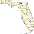
Soon after the Treaty of Moultrie in 1823 was delivered, Hamilton County was established as part of the original 15 counties in Florida. White settlers mostly from Georgia and South Carolina moved into the area in earnest between 1827 through the 1840s. In 1840, the inhabitants were calling the settlement "Pulaski"; others called it "Wall". Daniel Bell, living just outside the settlement in 1824, was county judge in 1828, appointed under the authority of the Acting Territorial Governor McCarty in Tallahassee. In 1839, he was a member of the Territorial Legislative Council. Legend has it that Bell, also considered to be the first settler of the county, disagreed with the names that were coming into use for places in the area. He met with locals (one of them named Simon Whitehurst, one of the few Revolutionary War veterans in Florida, buried in Jasper) and other friends, and decided to submit the name of "Jasper", in honor of Revolutionary War veteran William Jasper, to the territorial capitol in Tallahassee. There the name was registered and incorporated as documented in the Territorial Legislative Journal. In 1841, the Jasper Post Office was established, ending any discussion on names for the town. Florida became a state in 1845, and thirteen years later on March 2, 1858, the town's leaders incorporated the town of Jasper.

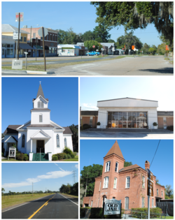
The early history and specific makeup of Jasper is rather vague except for scant records that survived several courthouse fires in the late 1800s. What we do know is that the original town was built about a mile south of its current location, near the site of the present day Hamilton Correctional Institution. The original courthouse and a stockade stood where Evergreen Cemetery is located. The citizens fought Seminole raiding parties throughout the early periods, the last Seminole War ending in 1858. In 1861, the Civil War came to Jasper. The Jasper Blues ("I" Company 2nd Infantry CSA) was created from Jasper and county citizens. The unit rendezvoused west of Jacksonville and were shipped by train to Virginia, arriving on the day of the First Battle of Manassas. They were eventually made a part of the First Corps (Stonewall Jackson's) of the Army of Northern Virginia led by General Robert E. Lee. A school in Jasper was named in Lee's honor and is occupied today by the County School Board Offices.

First United Methodist Church First Methodist Church, Jasper.JPG
First United Methodist Church

In 1865, the Savannah, Florida, and Western railway was completed, and a depot was built about a mile north of the town center. Businesses and homes migrated toward the railroad, and eventually the current town was established along that line. The town grew in earnest between 1890 and 1930, with a rich trade in turpentine, tobacco, cotton, and pine lumber. Jasper reached its pinnacle in the 1920s, with a booming population of over 2,000. Most of Jasper's present buildings were built during this 40-year period.

Since the 1920s, Jasper has seen many economic changes. The leading cotton industry gave way to the turpentine industry, turpentine to lumber, lumber to tobacco, and finally tobacco to phosphate mining. The completion of Interstate 75 in the late 1950s caused further decline as tourists and shipping bypassed the city.

In 2002, city officials extended the city limits and infrastructure to the intersection of US 129 and Interstate 75, and built infrastructure (water and sewer) with the help of county officials to the Hamilton County Industrial Park along US 41 in order to encourage economic growth and development. Since that time several new businesses have moved into the area, and the new high school has been built along the route.

The large jump in population between 2000 (1,780) and 2010 (4,546) was due to the incorporation of land containing the Hamilton County Correctional Facility into the city limits.

The first settlement in Hamilton County was called Micco Town or more accurately Hala-at-aha Micco which is interpreted as "Chief of the Miccosukee"; therefore, it is strongly believed to have been the home of Chief Billy Bowlegs who signed the 1823 Treaty of Moultrie.

Geography

Jasper is located in central Hamilton County at 30°31′08″N82°57′04″W / 30.518856°N 82.951194°W / 30.518856; -82.951194 . [5] It is set in the North Florida lowlands 90 miles (140 km) west of Jacksonville, 85 miles (137 km) east of Tallahassee, 32 miles (51 km) southeast of Valdosta, Georgia, and 30 miles (48 km) northwest of Lake City. The city is sits on a slightly higher elevated area surrounded by lowland.

U.S. Routes 41 and 129 run concurrently through the center of Jasper. US 41 continues northwest to Jennings and then into Georgia, and southeast to White Springs, while US 129 runs north to Statenville, Georgia and south to Live Oak. Interstate 75 passes close to Jasper, with access from Exit 451 (US 129) 5 miles (8 km) south of town, and from Exit 460 (Florida State Road 6) 7 miles (11 km) west of city.

According to the U.S. Census Bureau, Jasper has an area of 2.3 square miles (5.9 km2), all of it land. [6]

Climate

The City of Jasper is part of the humid subtropical climate zone with a Köppen Climate Classification of "Cfa" (C = mild temperate, f = fully humid, and a = hot summer).

Climate data for Jasper, Florida, 1991–2020 normals, extremes 19502022
MonthJanFebMarAprMayJunJulAugSepOctNovDecYear
Record high °F (°C)84
(29)
89
(32)
92
(33)
95
(35)
102
(39)
104
(40)
104
(40)
103
(39)
102
(39)
99
(37)
90
(32)
86
(30)
104
(40)
Mean maximum °F (°C)78.6
(25.9)
80.7
(27.1)
84.6
(29.2)
87.9
(31.1)
92.9
(33.8)
95.9
(35.5)
96.5
(35.8)
96.0
(35.6)
94.0
(34.4)
89.8
(32.1)
84.2
(29.0)
80.2
(26.8)
97.8
(36.6)
Mean daily maximum °F (°C)63.0
(17.2)
66.4
(19.1)
72.2
(22.3)
78.0
(25.6)
84.5
(29.2)
88.3
(31.3)
90.2
(32.3)
89.3
(31.8)
86.6
(30.3)
79.9
(26.6)
71.5
(21.9)
65.3
(18.5)
77.9
(25.5)
Daily mean °F (°C)50.7
(10.4)
53.9
(12.2)
59.0
(15.0)
65.1
(18.4)
72.3
(22.4)
78.0
(25.6)
80.2
(26.8)
79.7
(26.5)
76.5
(24.7)
68.1
(20.1)
58.8
(14.9)
53.1
(11.7)
66.3
(19.1)
Mean daily minimum °F (°C)38.4
(3.6)
41.3
(5.2)
45.8
(7.7)
52.2
(11.2)
60.2
(15.7)
67.7
(19.8)
70.2
(21.2)
70.1
(21.2)
66.4
(19.1)
56.4
(13.6)
46.0
(7.8)
41.0
(5.0)
54.6
(12.6)
Mean minimum °F (°C)22.4
(−5.3)
25.6
(−3.6)
30.0
(−1.1)
39.3
(4.1)
48.1
(8.9)
60.0
(15.6)
65.5
(18.6)
64.8
(18.2)
56.8
(13.8)
41.4
(5.2)
30.7
(−0.7)
26.6
(−3.0)
20.9
(−6.2)
Record low °F (°C)4
(−16)
14
(−10)
19
(−7)
27
(−3)
39
(4)
47
(8)
55
(13)
58
(14)
38
(3)
29
(−2)
15
(−9)
9
(−13)
4
(−16)
Average precipitation inches (mm)4.60
(117)
4.00
(102)
4.58
(116)
3.77
(96)
3.17
(81)
6.78
(172)
5.88
(149)
6.30
(160)
4.94
(125)
2.87
(73)
2.38
(60)
3.37
(86)
52.64
(1,337)
Average precipitation days (≥ 0.01 in)8.17.67.75.95.712.613.113.79.05.35.47.1101.2
Source: NOAA [7] [8]

Demographics

Historical population
CensusPop.Note
1870 138
1880 311125.4%
1900 993
1910 1,73074.2%
1920 1,260−27.2%
1930 1,74838.7%
1940 1,722−1.5%
1950 2,32735.1%
1960 2,103−9.6%
1970 2,2215.6%
1980 2,093−5.8%
1990 2,0990.3%
2000 1,780−15.2%
2010 4,546155.4%
2020 3,621−20.3%
U.S. Decennial Census [9]

2010 and 2020 census

Jasper racial composition
(Hispanics excluded from racial categories)
(NH = Non-Hispanic)
RacePop 2010 [10] Pop 2020 [11] % 2010% 2020
White (NH)1,8091,41239.79%38.99%
Black or African American (NH)2,2801,78750.15%49.35%
Native American or Alaska Native (NH)1350.29%0.14%
Asian (NH)23100.51%0.28%
Pacific Islander or Native Hawaiian (NH)000.00%0.00%
Some other race (NH)470.09%0.19%
Two or more races/Multiracial (NH)29640.64%1.77%
Hispanic or Latino (any race)3883368.53%9.28%
Total4,5463,621100.00%100.00%

As of the 2020 United States census, there were 3,621 people, 405 households, and 222 families residing in the city. [12]

As of the 2010 United States census, there were 4,546 people, 1,208 households, and 679 families residing in the city. [13]

2000 census

As of the census [3] of 2000, there were 1,780 people, 742 households, and 488 families residing in the city. The population density was 911.2 inhabitants per square mile (351.8/km2). There were 878 housing units at an average density of 449.4 per square mile (173.5/km2). The racial makeup of the city was 52.25% White, 45.67% African American, 0.06% Native American, 0.28% Asian, 0.73% from other races, and 1.01% from two or more races. Hispanic or Latino of any race were 3.09% of the population.

In 2000, there were 742 households, out of which 28.4% had children under the age of 18 living with them, 37.7% were married couples living together, 23.5% had a female householder with no husband present, and 34.2% were non-families. 31.5% of all households were made up of individuals, and 15.0% had someone living alone who was 65 years of age or older. The average household size was 2.40 and the average family size was 3.01.

In 2000, in the city, the population was spread out, with 29.3% under the age of 18, 8.3% from 18 to 24, 23.3% from 25 to 44, 22.5% from 45 to 64, and 16.6% who were 65 years of age or older. The median age was 35 years. For every 100 females, there were 74.3 males. For every 100 females age 18 and over, there were 69.5 males.

In 2000, the median income for a household in the city was $19,018, and the median income for a family was $23,664. Males had a median income of $30,938 versus $17,244 for females. The per capita income for the city was $12,844. About 30.5% of families and 37.4% of the population were below the poverty line, including 56.5% of those under age 18 and 18.7% of those age 65 or over.

Education

Virginia B. Chandler Public Library Virginia B. Chandler Public Library, Jasper.JPG
Virginia B. Chandler Public Library

The Hamilton County School District operates the public schools serving Jasper, Hamilton County Elementary School and Hamilton County High School, both in an unincorporated area of the county.

Central Hamilton Elementary School in Jasper previously served the city. [14] It was consolidated into a new elementary school, Hamilton County Elementary School, [15] located in an unincorporated area south of Jasper. [16] Its opening is scheduled for August 2017. [17]

The Suwannee River Regional Library System operates the Jasper Public Library (Virginia B. Chandler Public Library) in Jasper. [18]

Notable people

Local publications

Related Research Articles

<span class="mw-page-title-main">Columbia County, Florida</span> County in Florida, United States

Columbia County is a county located in the north central portion of the U.S. state of Florida. As of the 2020 census, the population was 69,698, up from 67,531 at the 2010 census. Its county seat is Lake City.

<span class="mw-page-title-main">Dixie County, Florida</span> County in Florida, United States

Dixie County is a county located in the Big Bend region of the northern part of the U.S. state of Florida. As of the 2020 census, the population was 16,759. Its county seat is Cross City.

<span class="mw-page-title-main">Hamilton County, Florida</span> County in Florida, United States

Hamilton County is a county located in the north central portion of the U.S. state of Florida. As of the 2020 census, the population was 14,004, down from 14,799 at the 2010 census. Its county seat is Jasper.

<span class="mw-page-title-main">Lafayette County, Florida</span> County in Florida, United States

Lafayette County is a county located in the north central portion of the state of Florida. As of the 2020 census, the population was 8,226, making it the second-least populous county in Florida. The county seat is Mayo. Lafayette County is a prohibition or partially dry county, allowing retail sales of beer.

<span class="mw-page-title-main">Madison County, Florida</span> County in Florida, United States

Madison County is a county located in the north central portion of the state of Florida, and borders the state of Georgia to the north. As of the 2020 census, the population was 17,968. Its county seat is also called Madison.

<span class="mw-page-title-main">Suwannee County, Florida</span> County in Florida, United States

Suwannee County is a county located in the north central portion of the state of Florida. As of the 2020 census, the population was 43,474, up from 41,551 in 2010. Its county seat is Live Oak. Suwannee County was a dry county until August 2011, when the sale of alcoholic beverages became legal in the county.

<span class="mw-page-title-main">Taylor County, Florida</span> County in Florida, United States

Taylor County is a county located in the Big Bend region in the northern part of the U.S. state of Florida. As of the 2020 census, the population was 21,796. Its county seat is Perry. The county hosts the annual Florida Forest Festival and has been long known as the "Tree Capital of the South" since a 1965 designation from then-Governor W. Haydon Burns.

<span class="mw-page-title-main">Davie, Florida</span> City in Florida, United States

Davie is a town in Broward County, Florida, United States, approximately 24 miles (39 km) north of Miami. The town's population was 110,320 at the 2020 census, Davie is a principal town of the Miami metropolitan area. Horseback riding is common, as much of its historic buildings include ranches and other Western establishments.

<span class="mw-page-title-main">Inverness, Florida</span> City in Florida, United States

Inverness is a city and the county seat of Citrus County, Florida, United States. It is near the 10,950-acre (4,430 ha) Flying Eagle Preserve. As of the 2020 census, the population was 7,543.

<span class="mw-page-title-main">Jennings, Florida</span> Town in the state of Florida, United States

Jennings is a town in Hamilton County, Florida, United States. The population was 749 at the 2020 census, down from 878 at the 2010 census. Actor Andrew Prine was born here.

<span class="mw-page-title-main">White Springs, Florida</span> Town in the state of Florida, United States

White Springs is a town in northern Florida on the Suwannee River. The population was 777 at the 2010 census, down from 819 at the 2000 census. Home of the annual Florida Folk Festival, it is a tourist destination noted for historic charm, antique shops and river recreation.

<span class="mw-page-title-main">Clewiston, Florida</span> City in Florida, United States

Clewiston is a city in Hendry County, Florida, United States. Its location is 80 miles (130 km) northwest of Fort Lauderdale on the Atlantic coastal plain. The population was 7,327 at the 2020 census.

<span class="mw-page-title-main">St. Cloud, Florida</span> City in Florida, United States

St. Cloud or Saint Cloud is a city in northern Osceola County, Florida, United States. It is on the southern shore of East Lake Tohopekaliga in Central Florida, about 26 miles (41.8 km) southeast of Orlando. The population was 35,183 in the 2010 census, and 54,579 in the 2019 census estimate. The city is part of the Orlando–Kissimmee–Sanford metropolitan area.

<span class="mw-page-title-main">Altamonte Springs, Florida</span> City in Florida, United States

Altamonte Springs is a suburban city in Central Florida in Seminole County, Florida, United States, which had a population of 46,231 at the 2020 United States Census. The city is in the northern suburbs of the Orlando–Kissimmee–Sanford Metropolitan Statistical Area, which the United States Census Bureau estimated had a population of 2,054,574 in 2008.

<span class="mw-page-title-main">Casselberry, Florida</span> City in Florida

Casselberry is a city in Seminole County, Florida, United States. The city is part of the Orlando–Kissimmee–Sanford Metropolitan Statistical Area. Its population was 28,794 at the 2020 census.

<span class="mw-page-title-main">Lake Mary, Florida</span> City in Florida, United States

Lake Mary is a suburban city that is located in the Greater Orlando metropolitan area in Seminole County, Florida, United States, and is located in Central Florida. The population was 16,798 at the 2020 census.

<span class="mw-page-title-main">Longwood, Florida</span> City in Florida, United States

Longwood is a city in Seminole County, Florida, United States. It is part of the Orlando–Kissimmee–Sanford, Florida Metropolitan Statistical Area. The population was 15,087 at the 2020 census.

<span class="mw-page-title-main">Branford, Florida</span> Town in Florida, United States

Branford is a town in Suwannee County, Florida, United States. The population was 712 at the 2010 census.

<span class="mw-page-title-main">Moultrie, Georgia</span> City in Georgia, United States

Moultrie is the county seat and largest city of Colquitt County, Georgia, United States. It is the third largest city in Southwest Georgia, behind Thomasville and Albany. As of the 2020 census, Moultrie's population was 14,638. It was originally known as Ochlockoney until it was incorporated by the Georgia General Assembly in 1859. Moultrie is an agricultural community set in the Southern Rivers part of Georgia.

<span class="mw-page-title-main">Bowlegs, Oklahoma</span> Town in Oklahoma, United States

Bowlegs is a town in Seminole County, Oklahoma, United States. The population was 357 at the time of the 2020 census.

References

  1. "FLORIDA CITIES BY INCORPORATION YEAR" (PDF). Florida League of Cities. Retrieved December 30, 2023.
  2. "2020 U.S. Gazetteer Files". United States Census Bureau. Retrieved October 31, 2021.
  3. 1 2 "U.S. Census website". United States Census Bureau . Retrieved January 31, 2008.
  4. "US Board on Geographic Names". United States Geological Survey. October 25, 2007. Retrieved January 31, 2008.
  5. "US Gazetteer files: 2010, 2000, and 1990". United States Census Bureau. February 12, 2011. Retrieved April 23, 2011.
  6. "Geographic Identifiers: 2010 Demographic Profile Data (G001): Jasper city, Florida". American Factfinder. U.S. Census Bureau. Retrieved April 25, 2017.[ dead link ]
  7. "NOWData - NOAA Online Weather Data". National Oceanic and Atmospheric Administration . Retrieved June 25, 2021.
  8. "Summary of Monthly Normals 1991–2020". National Oceanic and Atmospheric Administration . Retrieved June 25, 2021.
  9. "Census of Population and Housing". Census.gov. Retrieved June 4, 2015.
  10. "P2 HISPANIC OR LATINO, AND NOT HISPANIC OR LATINO BY RACE - 2010: DEC Redistricting Data (PL 94-171) - Jasper city, Florida". United States Census Bureau .
  11. "P2 HISPANIC OR LATINO, AND NOT HISPANIC OR LATINO BY RACE - 2020: DEC Redistricting Data (PL 94-171) - Jasper city, Florida". United States Census Bureau .
  12. "S1101 HOUSEHOLDS AND FAMILIES - 2020: Jasper city, Florida". United States Census Bureau .
  13. "S1101 HOUSEHOLDS AND FAMILIES - 2010: Jasper city, Florida". United States Census Bureau .
  14. Home Archived 2017-04-08 at the Wayback Machine . Central Hamilton Elementary School. Retrieved on April 8, 2017.
  15. Taylor, Joyce Marie (June 12, 2014). "Hamilton: New site chosen for consolidated elementary school". Suwannee Democrat. Archived from the original on April 8, 2017. Retrieved April 8, 2017.
  16. "Hamilton County set to break ground on new elementary school". WCTV. June 27, 2016. Retrieved April 8, 2017. "The groundbreaking ceremony will take place at 5686 U.S. Hwy 129 South in Jasper."
  17. "Hamilton: Culpepper/Gray selected to construct new elementary school". Suwannee Democrat. July 27, 2015. Archived from the original on May 23, 2016. Retrieved April 8, 2017.
  18. Home page. Virginia B. Chandler Public Library. Retrieved on April 8, 2017. "Jasper Public Library 311 Hatley Street NE Jasper, FL 32052"