Wauchula, Florida | |
---|---|
City of Wauchula | |
Motto(s): "Building New Beginnings From Old Traditions" "Cucumber Capital of the World" | |
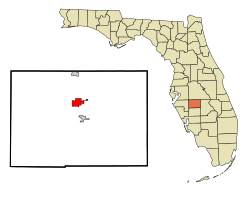
Coordinates: 27°32′46″N81°48′52″W / 27.54611°N 81.81444°W | |
Country | United States of America |
State | Florida |
County | Hardee |
Incorporated | September 29, 1902 |
Government | |
• Type | Commission–Manager |
• Mayor | Keith Nadachay, Jr. |
• Mayor Pro Tem | Neda Cobb |
• Commissioners | Russell Graylin Smith, Sherri Albritton, and Gary Smith |
• City Manager | Olivia Minshew |
• City Clerk | Stephanie Camacho |
Area | |
• Total | 3.27 sq mi (8.46 km2) |
• Land | 3.27 sq mi (8.46 km2) |
• Water | 0.00 sq mi (0.00 km2) |
Elevation | 112 ft (34 m) |
Population (2020) | |
• Total | 4,900 |
• Density | 1,499.85/sq mi (579.13/km2) |
Time zone | UTC-5 (Eastern (EST)) |
• Summer (DST) | UTC-4 (EDT) |
ZIP code | 33873 |
Area code | 863 |
FIPS code | 12-75375 [2] |
GNIS feature ID | 0292949 [3] |
Website | cityofwauchula |
Wauchula is a city and the county seat of Hardee County, Florida, United States. As of the 2020 census, it had a population of 4,900.
Wauchula has been called the "cucumber capital of the world", although citrus has become a more important agricultural crop over the past few decades. It is home to the downtown's Wauchula Historic District and Albert Carlton Estate.
The exact coordinates for the City of Wauchula is located at 27°32′46″N81°48′52″W / 27.54611°N 81.81444°W .
Wauchula is located in north-central Hardee County. U.S. Route 17 passes through the city, leading north 25 miles (40 km) to Bartow and south 24 miles (39 km) to Arcadia. Within the county, Zolfo Springs is 4 miles (6 km) to the south on US 17 and Bowling Green is 6 miles (10 km) to the north.
According to the United States Census Bureau, Wauchula has an area of 3.3 square miles (8.6 km2), all land.
Hurricane Charley hit Wauchula at c. 5:30 on Friday, August 13, 2004, causing more than $750 million in damage. Sustained winds of 140 mph (230 km/h), with gusts of over 160 mph (260 km/h), were clocked in downtown Wauchula. [4] The entire area had either no running water, or contaminated water for one week. Power was lost to many sections for nearly three weeks, with school canceled for two weeks. The area was declared a federal disaster area after 85% of its buildings were either damaged or destroyed. [5] There was a curfew set for the area for weeks after from 8 pm to 7 am.
The climate in this area is characterized by hot, humid summers and warm winters. According to the Köppen climate classification system, Wauchula has a humid subtropical climate zone (Cfa).
Climate data for Wauchula, Florida, 1991–2020 normals, extremes 1933–present | |||||||||||||
---|---|---|---|---|---|---|---|---|---|---|---|---|---|
Month | Jan | Feb | Mar | Apr | May | Jun | Jul | Aug | Sep | Oct | Nov | Dec | Year |
Record high °F (°C) | 90 (32) | 93 (34) | 94 (34) | 99 (37) | 104 (40) | 103 (39) | 102 (39) | 99 (37) | 99 (37) | 97 (36) | 92 (33) | 92 (33) | 104 (40) |
Mean maximum °F (°C) | 83.9 (28.8) | 86.0 (30.0) | 87.1 (30.6) | 91.2 (32.9) | 94.2 (34.6) | 95.8 (35.4) | 95.6 (35.3) | 95.7 (35.4) | 94.3 (34.6) | 91.5 (33.1) | 87.2 (30.7) | 84.6 (29.2) | 96.9 (36.1) |
Mean daily maximum °F (°C) | 72.7 (22.6) | 76.2 (24.6) | 79.6 (26.4) | 84.2 (29.0) | 88.7 (31.5) | 90.7 (32.6) | 91.8 (33.2) | 92.0 (33.3) | 90.1 (32.3) | 85.7 (29.8) | 79.5 (26.4) | 75.0 (23.9) | 83.8 (28.8) |
Daily mean °F (°C) | 60.2 (15.7) | 62.9 (17.2) | 66.2 (19.0) | 71.0 (21.7) | 76.3 (24.6) | 80.5 (26.9) | 81.9 (27.7) | 82.3 (27.9) | 80.8 (27.1) | 75.3 (24.1) | 67.8 (19.9) | 63.0 (17.2) | 72.4 (22.4) |
Mean daily minimum °F (°C) | 47.7 (8.7) | 49.6 (9.8) | 52.9 (11.6) | 57.7 (14.3) | 63.9 (17.7) | 70.3 (21.3) | 72.1 (22.3) | 72.7 (22.6) | 71.5 (21.9) | 64.9 (18.3) | 56.0 (13.3) | 51.0 (10.6) | 60.9 (16.1) |
Mean minimum °F (°C) | 31.1 (−0.5) | 34.0 (1.1) | 37.9 (3.3) | 45.2 (7.3) | 54.4 (12.4) | 65.2 (18.4) | 68.6 (20.3) | 69.1 (20.6) | 66.1 (18.9) | 50.2 (10.1) | 41.4 (5.2) | 34.8 (1.6) | 29.5 (−1.4) |
Record low °F (°C) | 20 (−7) | 24 (−4) | 23 (−5) | 34 (1) | 40 (4) | 51 (11) | 61 (16) | 61 (16) | 55 (13) | 37 (3) | 24 (−4) | 21 (−6) | 20 (−7) |
Average precipitation inches (mm) | 2.29 (58) | 2.18 (55) | 2.99 (76) | 2.92 (74) | 3.51 (89) | 8.46 (215) | 7.69 (195) | 8.46 (215) | 6.32 (161) | 3.09 (78) | 1.96 (50) | 2.13 (54) | 52.00 (1,321) |
Average precipitation days (≥ 0.01 in) | 4.9 | 4.1 | 4.2 | 4.3 | 5.8 | 13.4 | 13.1 | 13.9 | 11.3 | 5.8 | 3.9 | 4.5 | 89.2 |
Source: NOAA [6] [7] |
Census | Pop. | Note | %± |
---|---|---|---|
1910 | 1,099 | — | |
1920 | 2,081 | 89.4% | |
1930 | 2,574 | 23.7% | |
1940 | 2,710 | 5.3% | |
1950 | 2,872 | 6.0% | |
1960 | 3,411 | 18.8% | |
1970 | 3,007 | −11.8% | |
1980 | 3,296 | 9.6% | |
1990 | 3,253 | −1.3% | |
2000 | 4,368 | 34.3% | |
2010 | 5,001 | 14.5% | |
2020 | 4,900 | −2.0% | |
U.S. Decennial Census [8] |
Race | Pop 2010 [9] | Pop 2020 [10] | % 2010 | % 2020 |
---|---|---|---|---|
White (NH) | 2,179 | 2,008 | 43.57% | 40.98% |
Black or African American (NH) | 281 | 358 | 5.62% | 7.31% |
Native American or Alaska Native (NH) | 17 | 4 | 0.34% | 0.08% |
Asian (NH) | 49 | 41 | 0.98% | 0.84% |
Pacific Islander or Native Hawaiian (NH) | 1 | 2 | 0.02% | 0.04% |
Some other race (NH) | 4 | 5 | 0.08% | 0.10% |
Two or more races/Multiracial (NH) | 42 | 97 | 0.84% | 1.98% |
Hispanic or Latino (any race) | 2,428 | 2,385 | 48.55% | 48.67% |
Total | 5,001 | 4,900 | 100.00% | 100.00% |
As of the 2020 United States census, there were 4,900 people, 1,630 households, and 1,072 families residing in the city. [11]
As of the 2010 United States census, there were 5,001 people, 1,574 households, and 1,035 families residing in the city. [12]
As of the census [2] of 2000, there were 4,368 people, 1,431 households, and 985 families residing in the city. The population density was 1,669.6 inhabitants per square mile (644.6/km2). There were 1,562 housing units at an average density of 597.0 per square mile (230.5/km2). The racial makeup of the city was 73.44% White, 4.17% African American, 0.57% Native American, 0.30% Asian, 18.84% from other races, and 2.68% from two or more races. Hispanic or Latino of any race were 39.42% of the population.
In 2000, there were 1,431 households, out of which 36.5% had children under the age of 18 living with them, 48.9% were married couples living together, 14.8% had a female householder with no husband present, and 31.1% were non-families. 26.5% of all households were made up of individuals, and 13.1% had someone living alone who was 65 years of age or older. The average household size was 2.97 and the average family size was 3.57.
In 2000, in the city, the population was spread out, with 30.7% under the age of 18, 11.6% from 18 to 24, 26.9% from 25 to 44, 17.1% from 45 to 64, and 13.7% who were 65 years of age or older. The median age was 30 years. For every 100 females, there were 98.5 males. For every 100 females age 18 and over, there were 96.7 males.
In 2000, the median income for a household in the city was $25,931, and the median income for a family was $29,943. Males had a median income of $19,129 versus $15,867 for females. The per capita income for the city was $10,665. About 19.9% of families and 25.0% of the population were below the poverty line, including 30.0% of those under age 18 and 12.8% of those age 65 or over.
Wauchula Municipal Airport is a public-use airport located 5 miles (8.0 km) southwest of the central business district.
Center for Great Apes is a permanent sanctuary for rescued orangutans and chimpanzees.
The only hospital in Wauchula is AdventHealth Wauchula. [13]
Hardee County is a county located in the Florida Heartland of the Central Florida region in the U.S. state of Florida. As of the 2020 census, the population was 25,327. Its county seat is Wauchula.
Macclenny is a city and the county seat of Baker County, Florida. Located just west of Jacksonville, it is part of the Jacksonville, Florida Metropolitan Statistical Area. The population was 7,304 at the 2020 census, up from 6,374 in 2010.
Penney Farms is a town in central Clay County, Florida, United States. It is part of the Jacksonville, Florida Metropolitan Statistical Area. The population was 821 at the 2020 census, up from 749 at the 2010 census.
Beverly Beach is a town in Flagler County, Florida, United States. The Town of Beverly Beach is part of the Deltona–Daytona Beach–Ormond Beach, FL metropolitan statistical area. The population was 474 at the 2020 census, up from 338 in the 2010 census.
Bowling Green is a city in Hardee County, Florida, United States. The population was 2,405 at the 2020 census.
Zolfo Springs is a town in Hardee County, Florida, United States. It is part of the Florida Heartland region. The population was 1,737 at the 2020 census.
Bascom is a town in Jackson County, Florida, United States. The town is located on the Florida Panhandle in North Florida, and is 5 miles (8 km) south of the Alabama border. The population was 87 at the time of the 2020 census.
Cottondale is a city in Jackson County, Florida, United States. It is part of the Florida Panhandle and North Florida. The population was 848 at the 2020 census, down from 933 at the 2010 census.
Umatilla is a city in Lake County, Florida, United States. The population was 3,685 at the 2020 census. Umatilla is known as the Gateway to the Ocala National Forest, located in northern Lake County.
North Fort Myers is an unincorporated area and census-designated place (CDP) in Lee County, Florida, United States. The population was 42,719 at the 2020 census, up from 39,407 at the 2010 census. It is part of the Cape Coral-Fort Myers, Florida Metropolitan Statistical Area.
Inglis is a town in Levy County, Florida, United States. It is on U.S. Highway 19 near the Cross Florida Greenway. As of the 2020 census, the town had a population of 1,476, up from 1,325 at the 2010 census. It is part of the Gainesville, Florida Metropolitan Statistical Area.
Bristol is a city in and the county seat of Liberty County, Florida, United States. It is the only incorporated city in Liberty County. The population was 918 at the 2020 census.
Belleview is a city in Marion County, Florida, United States. The population was 5,413 at the 2020 census, up from 4,492 in 2010. It is part of the Ocala Metropolitan Statistical Area. The city's name comes from the French words belle and vue, meaning "beautiful view". "City with Small Town Charm" is the city's motto.
Coral Terrace is a suburban unincorporated community and census-designated place (CDP) in Miami-Dade County, Florida, United States. It is part of the Miami metropolitan area of South Florida. The population was 23,142 at the 2020 census, down from 24,376 in 2010.
Homestead Base is a census-designated place (CDP) in Miami-Dade County, Florida, United States. The CDP comprises the extent of Homestead Air Reserve Base plus some surrounding land. It is part of the Miami metropolitan area of South Florida. The population was 999 at the 2020 census.
Leisure City is an unincorporated community and census-designated place (CDP) in Miami-Dade County, Florida, United States, that includes the smaller, older community of Modello in its northwestern section. The CDP is most notable for the Coral Castle Museum, located in the Modello area. It is located in the Miami metropolitan area of South Florida. The population was 26,324 at the 2020 census, up from 22,655 in 2010.
Pinewood is an unincorporated community and census-designated place (CDP) in Miami-Dade County, Florida, United States. It is part of the Miami metropolitan area of South Florida. The population was 17,246 at the 2020 census.
Edgewood is a city in Orange County, Florida, United States. It is part of the Orlando–Kissimmee–Sanford Metropolitan Statistical Area. The population was 2,685 at the 2020 census.
Freeport is a city in Walton County, Florida, United States. It is part of the Crestview–Fort Walton Beach–Destin, Florida Metropolitan Statistical Area. As of the 2020, the population recorded by the U.S. Census Bureau was 5,861, up from 1,787 at the 2010 census. Freeport is one of the fastest growing cities in Florida. After the construction of the massive group of neighborhoods, Hammock Bay, the population grew by about 2 thousand.
Ebro is a town in Washington County, Florida, United States. The town is part of the Florida Panhandle, and located in North Florida. As of 2020, the population recorded by the U.S. Census Bureau is 237, down from 270 at the 2010 census. It is part of the Panama City—Panama City Beach, Florida Metropolitan Statistical Area.