Jacob City, Florida

Last updated

Jacob City, Florida
City of Jacob City
Motto: 
"Where Generations Take Pride in Calling this Home"
Jackson County Florida Incorporated and Unincorporated areas Jacob City Highlighted.svg
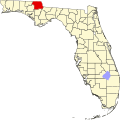
Location in Jackson County and the state of Florida
Coordinates: 30°53′40″N85°24′35″W / 30.89444°N 85.40972°W / 30.89444; -85.40972
Country Flag of the United States.svg  United States
State Flag of Florida.svg  Florida
County   Jackson
Settled
(Spanish Florida)
1780
Unincorporated (Jacob) 1869
Incorporated (City of Jacob City) 1983 [1]
Government
  Type Council-Manager
   Mayor Felix George
   Council Members Earnest Hall,
Josephine Lewis, and
Jonitha Williams
   City Manager Verloria T. Wilson
   City Clerk Joanne Simmons
   City Attorneys Harold Knowles and Roosevelt Randolph
Area
[2]
  Total3.22 sq mi (8.35 km2)
  Land3.05 sq mi (7.89 km2)
  Water0.18 sq mi (0.46 km2)
Elevation
135 ft (41 m)
Population
 (2020)
  Total217
  Density67/sq mi (26/km2)
Time zone UTC-6 (Central (CST))
  Summer (DST) UTC-5 (CDT)
Area code 850
FIPS code 12-35200 [3]
Website www.jacobcityfl.org

Jacob City is a city in Jackson County, Florida, United States. The city is population is predominantly African American, and located on the Florida Panhandle in North Florida. The population was 217 at the 2020 census. [4]

Contents

History

Jacob City's history begins in the early 19th century, when many formerly enslaved people moved from Webbville to isolate themselves from harassment from the white people there, most of whose residents moved to Marianna in 1882. Webbville no longer exists, but was located around the current location of U.S. 231 and State Road 73. Marianna was known as the rich man's town and no Black people were welcome. The first known settlement of Jacob City was by a white man named Jacob Jones, who accepted Black people to be housed on his property. That is where Jacob City got its name, as they would tell their friends, "Let's go to Jacob's." As Black people arrived to escape oppression, they moved farther down and made horse wagon trails into dirt roads, forming a small community.[ citation needed ]

By the mid-19th century, Jacob was Jackson County's first Black community. Black people started their own store, but the owner was murdered and the store was never re-opened. By the late 19th century, St. Mary Missionary Baptist Church was built on what is now Main Street. It is commemorated by a Jacob City historical marker. By the early 20th century, Jacob's dirt roads were improved and its population rose, but the poverty level was high due to the lack of education, as there was no school for Black children.

St. Mary's Church provided a school, but many of its students never made it past seventh grade because they had to help with farm work at home with their parents.[ citation needed ] In 1953, St. Paul's school was established near Campbellton as an elementary and high school where Jacob children could get a better education. The Campbellton school lasted until 1972. In the late 20th century, Jacob modernized and joined the Florida League of Cities. [5] In 1983, Jacob became Jacob City and built a city hall. [1]

Geography

The approximate coordinates for the City of Jacob City is located at 30°53′40″N85°24′35″W / 30.89444°N 85.40972°W / 30.89444; -85.40972 (30.894334, –85.409802). [6]

According to the United States Census Bureau, the city has a total area of 3.2 square miles (8.3 km2), of which 3.1 square miles (8.0 km2) is land and 0.1 square miles (0.26 km2) (4.02%) is water.

Climate

The climate in this area is characterized by hot, humid summers and generally mild winters. According to the Köppen climate classification, the City of Jacob City has a humid subtropical climate zone (Cfa).

Climate data for Jacob City, Florida (Marianna Municipal Airport), 1991–2020 normals
MonthJanFebMarAprMayJunJulAugSepOctNovDecYear
Mean daily maximum °F (°C)62.9
(17.2)
67.1
(19.5)
73.7
(23.2)
80.1
(26.7)
87.5
(30.8)
91.2
(32.9)
92.4
(33.6)
91.4
(33.0)
88.7
(31.5)
81.1
(27.3)
71.7
(22.1)
64.7
(18.2)
79.4
(26.3)
Daily mean °F (°C)51.8
(11.0)
55.4
(13.0)
61.5
(16.4)
67.6
(19.8)
75.9
(24.4)
81.1
(27.3)
82.7
(28.2)
82.1
(27.8)
78.7
(25.9)
69.5
(20.8)
59.6
(15.3)
53.9
(12.2)
68.3
(20.2)
Mean daily minimum °F (°C)40.7
(4.8)
43.8
(6.6)
49.2
(9.6)
55.1
(12.8)
64.2
(17.9)
71.1
(21.7)
73.0
(22.8)
72.8
(22.7)
68.6
(20.3)
58.0
(14.4)
47.4
(8.6)
43.0
(6.1)
57.2
(14.0)
Average precipitation inches (mm)4.04
(103)
4.49
(114)
5.01
(127)
3.72
(94)
3.15
(80)
5.07
(129)
5.10
(130)
4.93
(125)
4.06
(103)
3.06
(78)
3.67
(93)
4.81
(122)
51.11
(1,298)
Average precipitation days (≥ 0.01 in)10.09.49.07.46.412.413.913.69.48.18.910.7119.2
Source: NOAA [7] [8]

Demographics

Historical population
CensusPop.Note
1990 261
2000 2817.7%
2010 250−11.0%
2020 217−13.2%
U.S. Decennial Census [9]

2010 and 2020 census

Jacob City, Florida – Racial and Ethnic Composition
(NH = Non-Hispanic)
Note: the US Census treats Hispanic/Latino as an ethnic category. This table excludes Latinos from the racial categories and assigns them to a separate category. Hispanics/Latinos may be of any race.
Race / EthnicityPop 2000 [10] Pop 2010 [11] Pop 2020 [12] % 2000% 20102020
White alone (NH)1417134.98%6.80%5.99%
Black or African American alone (NH)26722619185.02%90.40%88.02%
Native American or Alaska Native alone (NH)0100.00%0.40%0.00%
Asian alone (NH)0000.00%0.00%0.00%
Pacific Islander or Native Hawaiian alone (NH)0000.00%0.00%0.00%
Some other race alone (NH)0010.00%0.00%0.46%
Two or more races/Multiracial (NH)0690.00%2.40%4.15%
Hispanic or Latino (any race)0030.00%0.00%1.38%
Total281250217100.00%100.00%100.00%

As of the 2020 United States census, there were 250 people, 122 households, and 65 families residing in the city. [13]

As of the 2010 United States census, there were 217 people, 130 households, and 91 families residing in the city. [14]

2000 census

As of the census [3] of 2000, there were 281 people, 99 households, and 73 families residing in the city. The population density was 90.7 inhabitants per square mile (35.0/km2). There were 116 housing units at an average density of 37.4 per square mile (14.4/km2). The racial makeup of the city was 4.98% White and 95.02% African American.

In 2000, there were 99 households, out of which 31.3% had children under the age of 18 living with them, 41.4% were married couples living together, 28.3% had a female householder with no husband present, and 25.3% were non-families. 22.2% of all households were made up of individuals, and 11.1% had someone living alone who was 65 years of age or older. The average household size was 2.84 and the average family size was 3.36.

In 2000, in the city, the population was spread out, with 30.6% under the age of 18, 7.8% from 18 to 24, 27.0% from 25 to 44, 20.6% from 45 to 64, and 13.9% who were 65 years of age or older. The median age was 35 years. For every 100 females, there were 84.9 males. For every 100 females age 18 and over, there were 66.7 males.

In 2000, the median income for a household in the city was $24,583, and the median income for a family was $22,292. Males had a median income of $25,481 versus $21,875 for females. The per capita income for the city was $11,037. About 24.7% of families and 26.0% of the population were below the poverty line, including 42.9% of those under the age of eighteen and 7.7% of those 65 or over.

Transportation

Highways

Florida 273.svg SR 273

CR 162 jct.svg CR 162 (Jacob Road)

US 231.svg US 231

Related Research Articles

<span class="mw-page-title-main">Archer, Florida</span> City in Florida, United States

Archer is a city in Alachua County, Florida, United States. It is part of the Gainesville metropolitan area. As of the 2020 census, the city had a population of 1,140.

Parker is a city in Bay County, Florida, United States. It is part of the Panama City–Lynn Haven–Panama City Beach Metropolitan Statistical Area. As of the 2020 US census, it had a population of 4,010.

<span class="mw-page-title-main">Fanning Springs, Florida</span> City in Florida, United States

Fanning Springs is a city in Gilchrist and Levy counties in the U.S. state of Florida. It is part of the Gainesville metropolitan area. The population was 1,182 at the 2020 census.

<span class="mw-page-title-main">Campbellton, Florida</span> Town in Florida, United States

Campbellton is a town in Jackson County, Florida, United States. The town is part of the Florida Panhandle in North Florida, and has a predominately African American majority. The population was 191 at the 2020 census.

<span class="mw-page-title-main">Cottondale, Florida</span> City in Florida, United States

Cottondale is a city in Jackson County, Florida, United States. It is part of the Florida Panhandle and North Florida. The population was 848 at the 2020 census, down from 933 at the 2010 census.

<span class="mw-page-title-main">Mascotte, Florida</span> City in Florida

Mascotte is a city in Lake County, Florida, United States. As of the 2020 census, the population was 6,609, up from 5,101 in 2010. It is part of the Orlando–Kissimmee–Sanford Metropolitan Statistical Area.

<span class="mw-page-title-main">Umatilla, Florida</span> City in Florida

Umatilla is a city in Lake County, Florida, United States. The population was 3,685 at the 2020 census. Umatilla is known as the Gateway to the Ocala National Forest, located in northern Lake County.

<span class="mw-page-title-main">Bronson, Florida</span> Town in Florida, United States

Bronson is a town and the county seat of Levy County, Florida, United States. The population was 1,140 at the 2020 census.

<span class="mw-page-title-main">Inglis, Florida</span> Town in Florida, United States

Inglis is a town in Levy County, Florida, United States. It is on U.S. Highway 19 near the Cross Florida Greenway. As of the 2020 census, the town had a population of 1,476.

<span class="mw-page-title-main">Coral Terrace, Florida</span> Census-designated place in Florida

Coral Terrace is a suburban unincorporated community and census-designated place (CDP) in Miami-Dade County, Florida, United States. It is part of the Miami metropolitan area of South Florida. The population was 23,142 at the 2020 census, down from 24,376 in 2010.

<span class="mw-page-title-main">Homestead Base, Florida</span> Census-designated place in Florida

Homestead Base is a census-designated place (CDP) in Miami-Dade County, Florida, United States. The CDP comprises the extent of Homestead Air Reserve Base plus some surrounding land. It is part of the Miami metropolitan area of South Florida. The population was 999 at the 2020 census.

<span class="mw-page-title-main">Leisure City, Florida</span> Census-designated place in Florida

Leisure City is an unincorporated community and census-designated place (CDP) in Miami-Dade County, Florida, United States, that includes the smaller, older community of Modello in its northwestern section. The CDP is most notable for the Coral Castle Museum, located in the Modello area. It is located in the Miami metropolitan area of South Florida. The population was 26,324 at the 2020 census, up from 22,655 in 2010.

<span class="mw-page-title-main">Pinewood, Florida</span> Census-designated place in Florida

Pinewood is an unincorporated community and census-designated place (CDP) in Miami-Dade County, Florida, United States. It is part of the Miami metropolitan area of South Florida. The population was 17,246 at the 2020 census.

<span class="mw-page-title-main">Westview, Florida</span> Census-designated place in Florida

Westview is a census-designated place (CDP) in Miami-Dade County, Florida, United States. It is part of the Miami metropolitan area of South Florida. The population was 9,923 at the 2020 census.

<span class="mw-page-title-main">Belle Isle, Florida</span> City in Florida, United States

Belle Isle is a city in Orange County, Florida, United States. The population was 7,032 at the 2020 census. It is part of the Orlando–Kissimmee–Sanford Metropolitan Statistical Area.

<span class="mw-page-title-main">Edgewood, Florida</span> City in Florida, United States

Edgewood is a city in Orange County, Florida, United States. It is part of the Orlando–Kissimmee–Sanford Metropolitan Statistical Area. The population was 2,685 at the 2020 census.

<span class="mw-page-title-main">Belleair Beach, Florida</span> City in Florida, United States

Belleair Beach is a city in Pinellas County, Florida, United States. It is part of Tampa–St. Petersburg–Clearwater Metropolitan Statistical Area, more commonly known as the Tampa Bay Area. The population was 1,633 at the 2020 census.

<span class="mw-page-title-main">Belleair Bluffs, Florida</span> City in Florida, United States

Belleair Bluffs is a city in Pinellas County, Florida, United States. It is part of the Tampa–St. Petersburg–Clearwater Metropolitan Statistical Area, more commonly known as the Tampa Bay Area. The population was 2,311 at the 2020 census.

<span class="mw-page-title-main">Highland Park, Florida</span> Village in Florida, United States

Highland Park is a village in Polk County, Florida, United States. Highland Park is part of the Lakeland–Winter Haven Metropolitan Statistical Area. Its population was 251 at the 2020 US census.

<span class="mw-page-title-main">Paxton, Florida</span> Town in the state of Florida, United States

Paxton is a town in Walton County, Florida, United States. Located near Britton Hill on the Alabama–Florida state line, it has the highest elevation of any in Florida. The Town of Paxton is located on the Florida Panhandle, and is part of the Crestview–Fort Walton Beach–Destin metropolitan area. The population was 556 as of the 2020 census.

References

  1. 1 2 "FLORIDA CITIES BY INCORPORATION YEAR WITH INCORPORATION & DISSOLUTION INFO" (PDF). www.flcities.com.
  2. "2020 U.S. Gazetteer Files". United States Census Bureau. Retrieved October 31, 2021.
  3. 1 2 "U.S. Census website". United States Census Bureau . Retrieved January 31, 2008.
  4. "Jacob City, Florida". United States Census Bureau . Retrieved February 6, 2024.
  5. "MUNICIPAL DIRECTORY: Florida League of Cities". Florida League of Cities.
  6. "US Gazetteer files: 2010, 2000, and 1990". United States Census Bureau. February 12, 2011. Retrieved April 23, 2011.
  7. "NOWData - NOAA Online Weather Data". National Oceanic and Atmospheric Administration . Retrieved June 25, 2021.
  8. "Summary of Monthly Normals 1991-2020". National Oceanic and Atmospheric Administration . Retrieved June 25, 2021.
  9. "Decennial Census of Population and Housing by Decades". US Census Bureau.
  10. "P004 Hispanic or Latino, and Not Hispanic or Latino by Race – 2000: DEC Summary File 1 – Jacob City city, Florida". United States Census Bureau .
  11. "P2 Hispanic or Latino, and Not Hispanic or Latino by Race – 2010: DEC Redistricting Data (PL 94-171) – Jacob City city, Florida". United States Census Bureau .
  12. "P2 Hispanic or Latino, and Not Hispanic or Latino by Race – 2020: DEC Redistricting Data (PL 94-171) – Jacob City city, Florida". United States Census Bureau .
  13. "S1101 HOUSEHOLDS AND FAMILIES - 2020: Jacob City city, Florida". United States Census Bureau .
  14. "S1101 HOUSEHOLDS AND FAMILIES - 2010: Jacob City city, Florida". United States Census Bureau .