Greenwood, Florida

Last updated

Greenwood, Florida
Town of Greenwood
Greenwood Town Hall.jpg
Greenwood Town Hall
Motto: 
"True Southern Living...in Northwest Florida"
Jackson County Florida Incorporated and Unincorporated areas Greenwood Highlighted.svg
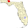
Location in Jackson County and the state of Florida
Coordinates: 30°52′25″N85°9′45″W / 30.87361°N 85.16250°W / 30.87361; -85.16250
Country Flag of the United States.svg  United States
State Flag of Florida.svg  Florida
County   Jackson
Incorporated 1927 [1]
Government
  Type Mayor-Council
   Mayor Phyllis Bowman
   Councilors Bryan Johnson,
Mamie Vann, and
Thomas Andreasen
   Town Clerk Alicia L. Corder
   Town Attorney George Little
Area
[2]
  Total4.56 sq mi (11.82 km2)
  Land4.56 sq mi (11.82 km2)
  Water0.00 sq mi (0.00 km2)
Elevation
115 ft (35 m)
Population
 (2020)
  Total539
  Density118.10/sq mi (45.60/km2)
Time zone UTC-6 (Central (CST))
  Summer (DST) UTC-5 (CDT)
ZIP code
32443
Area code 850
FIPS code 12-27600 [3]
GNIS feature ID0283427 [4]
Website www.townofgreenwood.org

Greenwood is a town in Jackson County, Florida, United States. It is part of the Florida Panhandle and located in North Florida, specifically Northwest Florida. The population was 539 at the 2020 census.

Contents

Geography

The exact coordinates for the Town of Greenwood are 30°52′25″N85°9′45″W / 30.87361°N 85.16250°W / 30.87361; -85.16250 (30.873517, –85.162431). [5]

According to the United States Census Bureau, the town has a total area of 4.8 square miles (12 km2), all land. Greenwood is ten miles from the county seat, Marianna, and the town of Malone. Both are much larger than Greenwood, and most residents of the area go to school or work in either of those two towns.

Climate

The climate in this area is characterized by hot, humid summers and generally mild winters. According to the Köppen climate classification, the Town of Greenwood has a humid subtropical climate zone (Cfa).

Demographics

Historical population
CensusPop.Note
1940 293
1960 427
1970 4495.2%
1980 57728.5%
1990 474−17.9%
2000 73555.1%
2010 686−6.7%
2020 539−21.4%
U.S. Decennial Census [6]

2010 and 2020 census

Greenwood racial composition
(Hispanics excluded from racial categories)
(NH = Non-Hispanic)
RacePop 2010 [7] Pop 2020 [8] % 2010% 2020
White (NH)44931965.45%59.18%
Black or African American (NH)20817430.32%32.28%
Native American or Alaska Native (NH)330.44%0.56%
Asian (NH)000.00%0.00%
Pacific Islander or Native Hawaiian (NH)000.00%0.00%
Some other race (NH)120.15%0.37%
Two or more races/Multiracial (NH)7201.02%3.71%
Hispanic or Latino (any race)18212.62%3.90%
Total686539100.00%100.00%

As of the 2020 United States census, there were 539 people, 213 households, and 154 families residing in the town. [9]

As of the 2010 United States census, there were 686 people, 260 households, and 181 families residing in the town. [10]

2000 census

As of the census [3] of 2000, there were 735 people, 296 households, and 200 families residing in the town. The population density was 153.3 inhabitants per square mile (59.2/km2). There were 335 housing units at an average density of 69.9 per square mile (27.0/km2). The racial makeup of the town was 66.67% White, 26.94% African American, 1.22% Native American, 0.95% Asian, 1.90% from other races, and 2.31% from two or more races. Hispanic or Latino of any race were 2.72% of the population.

In 2000, there were 300 households, out of which 29.1% had children under the age of 18 living with them, 52.4% were married couples living together, 11.8% had a female householder with no husband present, and 32.1% were non-families. 29.4% of all households were made up of individuals, and 13.5% had someone living alone who was 65 years of age or older. The average household size was 2.44 and the average family size was 2.99.

In 2000, in the town, the population was spread out, with 26.4% under the age of 18, 7.2% from 18 to 24, 24.6% from 25 to 44, 25.0% from 45 to 64, and 16.7% who were 65 years of age or older. The median age was 38 years. For every 100 females, there were 87.0 males. For every 100 females age 18 and over, there were 89.8 males.

In 2000, the median income for a household in the town was $28,750, and the median income for a family was $35,750. Males had a median income of $24,583 versus $22,083 for females. The per capita income for the town was $14,243. About 9.1% of families and 17.8% of the population were below the poverty line, including 21.6% of those under age 18 and 11.6% of those age 65 or over.

Transportation

Related Research Articles

<span class="mw-page-title-main">Palm Shores, Florida</span> Town in the state of Florida, United States

Palm Shores is a town in Brevard County, Florida. It is part of the Palm Bay–Melbourne–Titusville Metropolitan Statistical Area. The population was 1,200 at the 2020 US Census.

<span class="mw-page-title-main">Penney Farms, Florida</span> Town in the state of Florida, United States

Penney Farms is a town in Clay County, Florida, United States. It is part of the Jacksonville metropolitan area. The population was 821 at the 2020 census.

<span class="mw-page-title-main">Fanning Springs, Florida</span> City in Florida, United States

Fanning Springs is a city in Gilchrist and Levy counties in the U.S. state of Florida. It is part of the Gainesville metropolitan area. The population was 1,182 at the 2020 census.

<span class="mw-page-title-main">Ponce de Leon, Florida</span> Town in the state of Florida, United States

Ponce de Leon is a town in Holmes County, Florida, United States. The Town of Ponce de Leon was named after Spanish explorer, Juan Ponce de León. It is part of the Florida Panhandle in North Florida. The population was 504 at the 2020 census, down from 598 at the 2010 census.

<span class="mw-page-title-main">Cottondale, Florida</span> City in Florida, United States

Cottondale is a city in Jackson County, Florida, United States. It is part of the Florida Panhandle and North Florida. The population was 848 at the 2020 census, down from 933 at the 2010 census.

<span class="mw-page-title-main">Grand Ridge, Florida</span> Town in Florida, United States

Grand Ridge is a town in Jackson County, Florida, United States. It is part of the Florida Panhandle and North Florida. The population was 882 at the 2020 census.

<span class="mw-page-title-main">Malone, Florida</span> Town in the state of Florida, United States

Malone is a town in Jackson County, Florida, United States. The population was 1,959 at the 2020 census.

<span class="mw-page-title-main">Sneads, Florida</span> Town in the state of Florida, United States

Sneads is a town in Jackson County, Florida, United States. The population was 1,849 at the 2020 census.

<span class="mw-page-title-main">Astatula, Florida</span> Town in the state of Florida, United States

Astatula is a town in Lake County, Florida, United States. The population was 1,889 at the 2020 census. It is part of the Orlando–Kissimmee–Sanford Metropolitan Statistical Area.

<span class="mw-page-title-main">Howey-in-the-Hills, Florida</span> Town in the state of Florida, United States

Howey-In-The-Hills is a town in Lake County, Florida, United States. The population was 1,643 at the 2020 census. It is part of the Orlando–Kissimmee–Sanford Metropolitan Statistical Area.

<span class="mw-page-title-main">Montverde, Florida</span> Town in Florida, United States

Montverde is a town in Lake County, Florida, United States. The population was 1,655 at the 2020 census. It is part of the Orlando–Kissimmee–Sanford Metropolitan Statistical Area.

<span class="mw-page-title-main">Bronson, Florida</span> Town in Florida, United States

Bronson is a town and the county seat of Levy County, Florida, United States. The population was 1,140 at the 2020 census.

<span class="mw-page-title-main">Inglis, Florida</span> Town in Florida, United States

Inglis is a town in Levy County, Florida, United States. It is on U.S. Highway 19 near the Cross Florida Greenway. As of the 2020 census, the town had a population of 1,476.

<span class="mw-page-title-main">North Redington Beach, Florida</span> Town in the state of Florida, United States

North Redington Beach is a town in Pinellas County, Florida, United States. It is part of the Tampa–St. Petersburg–Clearwater Metropolitan Statistical Area, more commonly known as the Tampa Bay Area. The population was 1,495 at the 2020 census.

<span class="mw-page-title-main">Redington Beach, Florida</span> Town in the state of Florida, United States

Redington Beach is a town in Pinellas County, Florida, United States. It is part of the Tampa–St. Petersburg–Clearwater Metropolitan Statistical Area, more commonly called the Tampa Bay Area. The population was 1,376 at the 2020 census.

<span class="mw-page-title-main">Lake Hamilton, Florida</span> Town in the state of Florida, United States

Lake Hamilton is a town in Polk County, Florida, United States. The population was 1,537 at the 2020 census. It is part of the Lakeland–Winter Haven Metropolitan Statistical Area.

<span class="mw-page-title-main">Pomona Park, Florida</span> Town in the state of Florida, United States

Pomona Park is a town in Putnam County, Florida, United States. The Town of Pomona Park is part of the Palatka Micropolitan Statistical Area. The population was 784 at the 2020 census.

<span class="mw-page-title-main">St. Lucie Village, Florida</span> Town in the state of Florida, United States

St. Lucie Village is a town in St. Lucie County, Florida, United States. It is part of the Port St. Lucie Metropolitan Statistical Area. The population was 613 at the 2020 census.

<span class="mw-page-title-main">Pierson, Florida</span> Town in the state of Florida, United States

Pierson is a town in Volusia County, Florida, United States. The town is part of the Deltona–Daytona Beach–Ormond Beach, Florida Metropolitan Statistical Area. The population was 1,542 as of the 2020 census.

<span class="mw-page-title-main">Paxton, Florida</span> Town in the state of Florida, United States

Paxton is a town in Walton County, Florida, United States. Located near Britton Hill on the Alabama–Florida state line, it has the highest elevation of any in Florida. The Town of Paxton is located on the Florida Panhandle, and is part of the Crestview–Fort Walton Beach–Destin metropolitan area. The population was 556 as of the 2020 census.

References

  1. "FLORIDA CITIES BY INCORPORATION YEAR WITH INCORPORATION & DISSOLUTION INFO" (PDF). www.flcities.com.
  2. "2020 U.S. Gazetteer Files". United States Census Bureau. Retrieved October 31, 2021.
  3. 1 2 "U.S. Census website". United States Census Bureau . Retrieved January 31, 2008.
  4. "US Board on Geographic Names". United States Geological Survey. October 25, 2007. Retrieved January 31, 2008.
  5. "US Gazetteer files: 2010, 2000, and 1990". United States Census Bureau. February 12, 2011. Retrieved April 23, 2011.
  6. "Census of Population and Housing". Census.gov. Retrieved June 4, 2015.
  7. "P2 HISPANIC OR LATINO, AND NOT HISPANIC OR LATINO BY RACE - 2010: DEC Redistricting Data (PL 94-171) - Greenwood town, Florida". United States Census Bureau .
  8. "P2 HISPANIC OR LATINO, AND NOT HISPANIC OR LATINO BY RACE - 2020: DEC Redistricting Data (PL 94-171) - Greenwood town, Florida". United States Census Bureau .
  9. "S1101 HOUSEHOLDS AND FAMILIES - 2020: Greenwood town, Florida". United States Census Bureau .
  10. "S1101 HOUSEHOLDS AND FAMILIES - 2010: Greenwood town, Florida". United States Census Bureau .