Chipola River

Last updated
Chipolarivermap.png

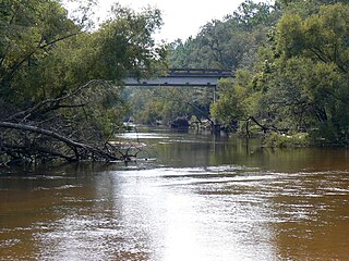
The Chipola River is a tributary of the Apalachicola River in western Florida. It is part of the ACF River Basin watershed.

Tributary stream or river that flows into a main stem river or lake

A tributary or affluent is a stream or river that flows into a larger stream or main stem river or a lake. A tributary does not flow directly into a sea or ocean. Tributaries and the main stem river drain the surrounding drainage basin of its surface water and groundwater, leading the water out into an ocean.

Apalachicola River 180 km (112mi) river in Florida, USA

The Apalachicola River is a river, approximately 112 mi (180 km) long in the state of Florida. The river's large watershed, known as the ACF River Basin, drains an area of approximately 19,500 square miles (50,505 km2) into the Gulf of Mexico. The distance to its farthest head waters in northeast Georgia is approximately 500 miles (800 km). Its name comes from the Apalachicola people, who used to live along the river.

Florida State of the United States of America

Florida is the southernmost contiguous state in the United States. The state is bordered to the west by the Gulf of Mexico, to the northwest by Alabama, to the north by Georgia, to the east by the Atlantic Ocean, and to the south by the Straits of Florida. Florida is the 22nd-most extensive, the 3rd-most populous, and the 8th-most densely populated of the U.S. states. Jacksonville is the most populous municipality in the state and the largest city by area in the contiguous United States. The Miami metropolitan area is Florida's most populous urban area. Tallahassee is the state's capital.

Contents

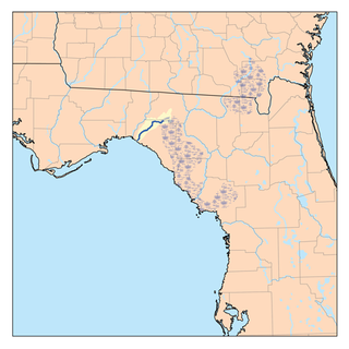
The 92.5-mile-long (148.9 km) [1] river crosses present-day Jackson, Calhoun and Gulf counties.

Jackson County, Florida County in Florida, United States

Jackson County is a county located in the U.S. state of Florida, on its northwestern border with Alabama. As of the 2010 census, the population was 49,746. Its county seat is Marianna.

Calhoun County, Florida County in Florida, United States

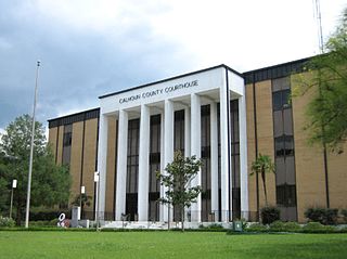
Calhoun County is a county located in the U.S. state of Florida. As of the 2010 census, the population was 14,625, making it the fifth-least populous county in Florida. Its county seat is Blountstown.

Gulf County, Florida County in Florida, United States

Gulf County is a county located in the panhandle of the U.S. state of Florida. As of the 2010 census, the population was 15,863. Its county seat is Port St. Joe.

Rapids in the Chipola River Sept09 Look&Tremble.JPG
Rapids in the Chipola River

The river flows through what is now preserved as the Dead Lakes State Recreation Area just before reaching its mouth at the confluence with the Apalachicola. The Dead Lakes were formed when the Apalachicola deposited sand bars blocking the mouth of the Chipola.

Dead Lakes State Recreation Area

Dead Lakes State Recreation Area is a Florida protected area located 1 mile (1.6 km) north of Wewahitchka off Florida State Road 71 and southwest of Tallahassee. It was formerly a Florida State Park and originally a fish hatchery operated by the Florida Fish and Wildlife Conservation Commission from 1936 until 1951. Activities include hiking, fishing, boating, camping, and wildlife viewing. Among the wildlife of the park are foxes, cotton rats, raccoons, opossums, white-tailed deer, rabbits, skunk, beavers, turtles, snakes and alligators. A variety of trees can be found in the park, including longleaf pine, magnolia and bald cypress trees. Amenities include a boat ramp, fresh water trails, nature trails, and a camping area. The recreation area is open from 8:00 am until sunset year-round.

The Chipola River flows for several miles south from the Dead Lakes, parallel to the Apalachicola River, before reaching its confluence with the larger river.

Confluence Meeting of two or more bodies of flowing water

In geography, a confluence occurs where two or more flowing bodies of water join together to form a single channel. A confluence can occur in several configurations: at the point where a tributary joins a larger river ; or where two streams meet to become the source of a river of a new name ; or where two separated channels of a river rejoin at the downstream end.

Chipola River crossing on US90/FL10 in Jackson County US90wb, Chipola River, Jackson County.jpg
Chipola River crossing on US90/FL10 in Jackson County

See also

Related Research Articles

ACF River Basin

The ACF River Basin is the drainage basin, or watershed, of the Apalachicola River, Chattahoochee River, and Flint River, in the Southeastern United States.

Little Missouri River (Arkansas) river in the United States of America

The Little Missouri River, or Little Mo, is a 147-mile-long (237 km) waterway that runs from the Ouachita Mountains of southwest Arkansas into the rolling hills area in the surrounding countryside.

Flint River (Georgia) river in the United States of America

The Flint River is a 344-mile-long (554 km) river in the U.S. state of Georgia. The river drains 8,460 square miles (21,900 km2) of western Georgia, flowing south from the upper Piedmont region south of Atlanta to the wetlands of the Gulf Coastal Plain in the southwestern corner of the state. Along with the Apalachicola and the Chattahoochee rivers, it forms part of the ACF basin. In its upper course through the red hills of the Piedmont, it is considered especially scenic, flowing unimpeded for over 200 miles (320 km). Historically, it was also called the Thronateeska River.

The Pinnebog River is a 39.4-mile-long (63.4 km) river in the Thumb region of the U.S. state of Michigan. The river flows into Lake Huron on the west side of the "tip" of the "thumb".

Tates Hell State Forest

Tate's Hell State Forest is 202,000 acres (819 km²) of land in Franklin and Liberty counties in Florida. The forest is located near Carrabelle off US 98 along the gulf coast. At one time, Tate's Hell supported at least 12 major habitats including: wet flatwoods, wet prairie, seepage slope, baygall, floodplain forest, floodplain swamp, basin swamp, upland hardwood forest, sandhill, pine ridges, dense titi swamp thickets and scrub. Tate's Hell State Forest is an important hydrologic area and includes a section of the New River. The park's watershed provides fresh water into the Apalachicola Bay, the Carrabelle River and the Ochlockonee River.

Little Manatee River River in the United States of America

The Little Manatee River flows 51 miles (82 km), from east of Fort Lonesome, Florida South of Hwy 674 and Earl Reynolds Rd In Hillsborough County through southern Hillsborough County, Florida including towns such as Sun City, Florida, and Gulf City, Florida and northern Manatee County, Florida into Tampa Bay. It has a drainage basin of 222 square miles (570 km2). It flows along the Little Manatee River State Park for part of its route. Portions of the river Such as Hayes Bayou and Mills Bayou have been designated as an Outstanding Florida Water and are part of the Cockroach Bay Aquatic Preserve.

Alapaha River river in the United States of America

The Alapaha River is a 202-mile-long (325 km) river in southern Georgia and northern Florida in the United States. It is a tributary of the Suwannee River, which flows to the Gulf of Mexico.

Chipola College is a state college in Marianna, Florida. It is a member of the Florida College System. In 2012 the school opened a $16 million 56,000 square foot center for the arts, including two theaters.

Ochlockonee River 332km (206mi) river in Florida and Georgia, USA

The Ochlockonee River is a fast running river, except where it has been dammed to form Lake Talquin in Florida, originating in Georgia and flowing for 206 miles (332 km) before terminating in Florida.

Rio Chama

The Rio Chama, a major tributary river of the Rio Grande, is located in the U.S. states of Colorado and New Mexico. The river is about 130 miles (210 km) long altogether. From its source to El Vado Dam its length is about 50 miles (80 km), from El Vado Dam to Abiquiu Dam is about 51 miles (82 km), and from Abiquiu Dam to its confluence with the Rio Grande is about 34 miles (55 km).

Withlacoochee River (Florida) River in Florida, United States

The Withlacoochee River originates in central Florida's Green Swamp, east of Polk City. It flows west, then north, and then turns northwest and finally west again before it empties into the Gulf of Mexico near Yankeetown. The river is 141 miles (227 km) long and has a drainage basin of 1,170 square miles (3,000 km2). It is believed to have been named after the Withlacoochee River to the north.

Econfina River river in the United States of America

The Econfina River is a minor river draining part of the Big Bend region of Florida, U.S.A. into Apalachee Bay. The river rises in San Pedro Bay near the boundary between Madison and Taylor counties, and flows 44 miles (71 km) through Taylor County to Apalachee Bay. It has a watershed of 239 square miles (620 km2).

Steinhatchee River River in Florida, United States of America

The Steinhatchee River is a short river in the Big Bend region of Florida in the United States. The river rises in the Mallory Swamp just south of Mayo in Lafayette County and flows for 34.5 miles (55.5 km) out of Lafayette County, forming the boundary between Dixie County and Taylor County to the Gulf of Mexico. It has a drainage basin of 586 square miles (1,520 km2). The river has also been known as the Hittenhatchee, Esteenhatchee and Isteenhatchee.

The Waccasassa River is a small, isolated river in Levy County, Florida, emptying into the Gulf of Mexico. The river is 29 miles (47 km) long, and has a drainage basin of 610 square miles (1,600 km2). Its tributaries include the Wekiva River. Three-quarters of the river is accessible only by canoe or kayak. The Waccasassa is one of the most undeveloped rivers in Florida. For most of its length it is surrounded by state owned or paper company owned land. Paper companies are generally required to leave an unharvested border along navigatible waterways. The mouth is protected by the Waccasassa Bay State Preserve Park.

The Northwest Florida Water Management District (NWFWMD) stretches from the St. Marks River Basin in Jefferson County to the Perdido River in Escambia County. The District is one of five water management districts in Florida created by the Water Resources Act of 1972. The District has worked for decades to protect and manage water resources in a sustainable manner for the continued welfare of people and natural systems across its 16-county region. It serves Bay, Calhoun, Escambia, Franklin, Gadsden, Gulf, Holmes, Jackson, Leon, Liberty, Okaloosa, Santa Rosa, Wakulla, Walton, Washington and western Jefferson County.

Black Creek (Florida) River in Florida, United States of America

Black Creek is a 13.0-mile-long (20.9 km) tributary of the St. Johns River. It is located in Clay County, Florida. Black Creek has two major tributaries; North Fork Black Creek and South Fork Black Creek. North Fork originates as an outflow from Kingsley Lake and flows north and then east through Camp Blanding and Jennings State Forest, meeting South Fork in Middleburg, Florida. North Fork Black Creek has Yellow Water Creek and Big Branch as its main tributaries. South Fork Black Creek is fed by areas of wetlands and numerous small streams. The confluence of North Fork Black Creek and South Fork Black Creek near Middleburg form the main channel of Black Creek.

The Alapahoochee River is a 14.4-mile-long (23.2 km) tributary of the Alapaha River in Georgia and Florida in the United States. Via the Alapaha and Suwannee rivers, its waters flow to the Gulf of Mexico.

Spring Creek is a 76.5-mile-long (123.1 km) tributary of the Flint River in southwest Georgia in the United States.

Dickey River river in the United States of America

The Dickey River is a stream on the Olympic Peninsula in the U.S. state of Washington. It has three main forks, the East Fork, West Fork, and Middle Fork Dickey Rivers. The main stem is formed by the confluence of the East and West Forks. The river and its forks rise in the northwestern part of the Olympic Peninsula and flow generally south and west to join the Quillayute River near its mouth on the Pacific Ocean.

References

  1. U.S. Geological Survey. National Hydrography Dataset high-resolution flowline data. The National Map Archived 2012-04-05 at WebCite , accessed April 15, 2011
International Standard Book Number Unique numeric book identifier

The International Standard Book Number (ISBN) is a numeric commercial book identifier which is intended to be unique. Publishers purchase ISBNs from an affiliate of the International ISBN Agency.

Coordinates: 30°48′44″N85°13′56″W / 30.8123025°N 85.2322681°W / 30.8123025; -85.2322681

Geographic coordinate system Coordinate system

A geographic coordinate system is a coordinate system that enables every location on Earth to be specified by a set of numbers, letters or symbols. The coordinates are often chosen such that one of the numbers represents a vertical position and two or three of the numbers represent a horizontal position; alternatively, a geographic position may be expressed in a combined three-dimensional Cartesian vector. A common choice of coordinates is latitude, longitude and elevation. To specify a location on a plane requires a map projection.