
Marion County is located in the northern portion of the U.S. state of Florida. As of the 2020 census, the population was 375,908. Its county seat is Ocala.

Lake Winnipesaukee is the largest lake in the U.S. state of New Hampshire, located in the Lakes Region at the foothills of the White Mountains. It is approximately 21 miles (34 km) long (northwest-southeast) and from 1 to 9 miles wide (northeast-southwest), covering 69 square miles (179 km2)—71 square miles (184 km2) when Paugus Bay is included—with a maximum depth of 180 feet (55 m). The center area of the lake is called The Broads.

Hume Dam, formerly the Hume Weir, is a major dam across the Murray River downstream of its junction with the Mitta River in the Riverina region of New South Wales, Australia. The dam's purpose includes flood mitigation, hydro-power, irrigation, water supply and conservation. The impounded reservoir is called Lake Hume, formerly the Hume Reservoir. It is a gated concrete gravity dam with four earth embankments and twenty-nine vertical undershot gated concrete overflow spillways.

Lake Alexandrina is a coastal freshwater lake located between the Fleurieu and Kangaroo Island and Murray and Mallee regions of South Australia, about 100 kilometres (62 mi) south-east of Adelaide. The lake adjoins the smaller Lake Albert and a coastal lagoon called The Coorong to its southeast, before draining into the Great Australian Bight via a short, narrow opening known as Murray Mouth.
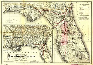
The Florida Central and Peninsular Railroad was the final name of a system of railroads throughout Florida, becoming part of the Seaboard Air Line Railway in 1900. The system, including some of the first railroads in Florida, stretched from Jacksonville west through Tallahassee and south to Tampa. Much of the FC&P network is still in service under the ownership of CSX Transportation.
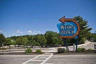
Weirs Beach is an area within the northern part of the city of Laconia in Belknap County, New Hampshire, United States. It is located on the southern shore of Lake Winnipesaukee. The cruise ship Mount Washington terminates there. It is a popular destination of bikers during Motorcycle Week every June.

Hongze Lake, previously known as Lake Hungtze or Hung-tse, is the fifth-largest freshwater lake in China. Although it is known to have existed from antiquity, it drastically increased in size during the Qing when the Yellow River—then still flowing south of Shandong—merged with the Huai. The increased sediment and flow combined to greatly expand the lake, swallowing the previous regional center of Sizhou and the Ming Zuling tombs. During the imperial and republican periods, the lake formed part of the border between Jiangsu and Anhui provinces but since 1955 the previous borders have been shifted to place it entirely under Jiangsu's administration. It is now encompassed by the counties of Sihong and Siyang in Suqian Prefecture and Xuyi and Hongze in Huai'an Prefecture. Since the establishment of the People's Republic of China, the lake has generally decreased in size as more of its inflow has been diverted for irrigation.
The Mayaimi were Native American people who lived around Lake Mayaimi in the Belle Glade area of Florida from the beginning of the Common Era until the 17th or 18th century. In the languages of the Mayaimi, Calusa, and Tequesta tribes, Mayaimi meant "big water." The origin of the language has not been determined, as the meanings of only ten words were recorded before extinction. The linguist Julian Granberry states that the language of the Calusa, Mayaimi and Tequesta people is related to the Tunica language. The current name, Okeechobee, is derived from the Hitchiti word meaning "big water". The Mayaimis have no linguistic or cultural relationship with the Miami people of the Great Lakes region. The city of Miami is named after the Miami River, which derived its name from Lake Mayaimi.
Lake Weir High School (LWHS) is a public high school located in unincorporated southeastern Marion County, Florida, United States. It is part of the Marion County School District and serves students residing in southeastern Marion County, including the Ocala National Forest, Silver Springs Shores and Summerfield. The school colors are purple and gold and its mascot is the hurricane.

Weir Hill Reservation is a 194-acre (0.79 km2) public park located in the town of North Andover, Massachusetts. The Trustees of Reservations owns and maintains the property.

Lake Miccosukee is a large swampy prairie lake in northern Jefferson County, Florida, located east of the settlement of Miccosukee. A small portion of the lake, its northwest corner, is located in Leon County. The small town of Miccosukee, Florida is located on the north eastern shore of the lake in Leon County.

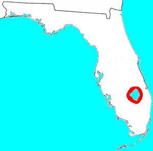
East Lake Weir is an unincorporated community in eastern Marion County, Florida, United States, on the east shore of Lake Weir. The community is part of the Ocala Metropolitan Statistical Area. The ZIP Code for East Lake Weir is 32133.

The Wekiva River is a 16.0-mile-long (25.7 km) river in Central Florida, north of Orlando in the United States. It originates in Apopka and joins the St. Johns River, the longest river in the state, in DeBary. The Wekiva River system includes the main stem joined by three main tributaries - Rock Springs Run, Blackwater Creek, and the Little Wekiva River - and about 30 contributing groundwater springs. It is designated as a Florida State Canoe Trail, an Outstanding Florida Water, and an Aquatic Preserve by the Florida Department of Environmental Protection. The Wekiva River system is also one of the two rivers in Florida federally designated as a National Wild and Scenic River for its scenery, recreation, geology, and diverse habitats.

Lake Harris is a lake in Lake County, Florida, United States, 31 miles (50 km) northwest of Orlando. It is part of the Upper Ocklawaha River Basin, a sub-watershed of the St. Johns River. It is one of seven lakes in the Harris Chain of Lakes or "Ocklawaha Chain of Lakes".

U.S. Route 27 (US 27) in Florida is a north–south United States Highway. It runs 496 miles (798 km) from the South Florida Metropolitan Area northwest to the Tallahassee Metropolitan Statistical Area. Throughout the state, US 27 has been designated the Claude Pepper Memorial Highway by the Florida Legislature. It was named after long-time Florida statesman Claude Pepper, who served in both the U.S. Senate and House of Representatives. The stretch running from Miami to South Bay was originally designated the Thomas E. Will Memorial Highway by the Florida Legislature in 1937 when that portion was known as Florida State Road 26. Will, the founder of Okeelanta, Florida, had worked for almost twenty years to get the state to build a road from Miami to the area south of Lake Okeechobee. For most of its length in the state, US 27 is a divided highway.
The Braden River is a 21-mile (34 km) waterway that drains an 83-square-mile (210 km2) area watershed in west-central Florida and is the largest tributary of the Manatee River.

Candler is an unincorporated community in Marion County, Florida, United States. It is located on County Road 464 between Silver Springs Shores and Lake Weir. The community is part of the Ocala Metropolitan Statistical Area. Candler's Zip Code is 32111.
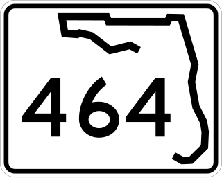
State Road 464 is a short state and county road in Marion County, Florida. The road is primarily in southern Ocala, but extends outside of the city limits.


